File:Cowley's_Circumnavigation_1699.jpg
From Wikipedia, the free encyclopedia
Original file (6,387 × 3,699 pixels, file size: 5.24 MB, MIME type: image/jpeg)
| This is a file from the Wikimedia Commons. Information from its description page there is shown below. Commons is a freely licensed media file repository. You can help. |
Summary
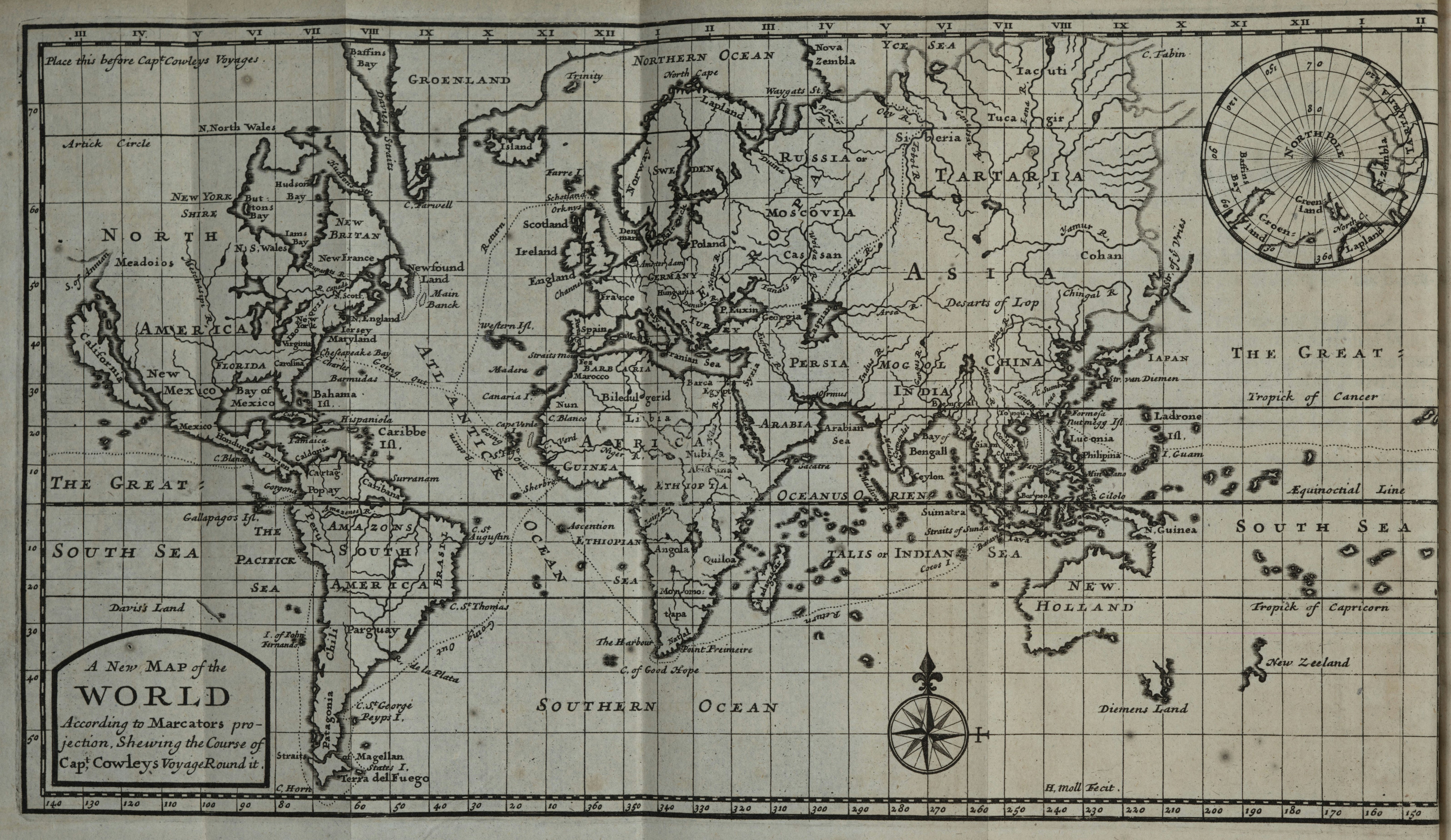
| DescriptionCowley's Circumnavigation 1699.jpg |
English: Herman Moll world map marked with the route of William Ambrosia Cowley's 1683–1686 circumnavigation of the world, included with the 1699 edition of his travels. Omits the initial passage from England to Virginia and the final passage from the Netherlands back to England. Includes an inset map of the North Pole, as known to the English in 1699. Title: A New Map of the World According to Marcators projection, Shewing the Course of Capt, Cowleys Voyage Round it. |
| Date | 1699, showing the course of Cowley's voyages 1683–1686 |
| Source | University of Kansas Kenneth Spenser Research Library copy (B82) of William Hacke's A Collection of Original Voyages..., 1st ed. |
| Author | Hermann Moll |
Licensing
| Public domainPublic domainfalsefalse |
|
This work is in the public domain in its country of origin and other countries and areas where the copyright term is the author's life plus 70 years or fewer. This work is in the public domain in the United States because it was published (or registered with the U.S. Copyright Office) before January 1, 1929. | |
| This file has been identified as being free of known restrictions under copyright law, including all related and neighboring rights. | |
https://creativecommons.org/publicdomain/mark/1.0/PDMCreative Commons Public Domain Mark 1.0falsefalse
| Annotations InfoField | This image is annotated: View the annotations at Commons |
Place this before Capt Cowleys Voyages.
GROENLAND
Island
Western Isl.
Iersey
Caribbe
Isl.
Barmudas
Going Out
Going Out
Going Out
Abisinia
Farre I.
Schetland
YCE SEA
Str. of ye Vries
IAPAN
Return
Return
Return
Gallapagos Isl.
Surranam
Monomo:
tapa
BRASIL
Caribana
WORLD
According to Marcators pro–
jection, Shewing the Course of
Capt, Cowleys Voyage Round it.
OCEANUS ORIEN
TALIS or INDIAN SEA
Tropick of Cancer
H, Moll Fecit.
Diemens Land
HOLLAND
SOUTH SEA
I. Guam
Tropick of Capricorn
SOUTH SEA
Æquinoctial Line
NORTHERN OCEAN
PACIFICK
SEA
Captions
Items portrayed in this file
depicts
image/jpeg
bcf05dd7d50cd7f202cab8cbeea1bc43175e8e4b
5,497,277 byte
3,699 pixel
6,387 pixel
File history
Click on a date/time to view the file as it appeared at that time.
| Date/Time | Thumbnail | Dimensions | User | Comment | |
|---|---|---|---|---|---|
| current | 06:56, 13 May 2023 | | 6,387 × 3,699 (5.24 MB) | LlywelynII | Uploaded a work by Will do soon from Will do soon with UploadWizard |
File usage
Metadata
This file contains additional information, probably added from the digital camera or scanner used to create or digitize it.
If the file has been modified from its original state, some details may not fully reflect the modified file.
| Date and time of data generation | 14:49, 13 May 2023 |
|---|---|
| Orientation | Normal |
| Software used | Windows Photo Editor 10.0.10011.16384 |
| File change date and time | 14:50, 13 May 2023 |
| Date and time of digitizing | 14:49, 13 May 2023 |
| DateTimeOriginal subseconds | 00 |
| DateTimeDigitized subseconds | 00 |
| Color space | sRGB |