File:Deforestacja_RioBranco.jpg
From Wikipedia, the free encyclopedia
Size of this preview: 383 × 599 pixels. Other resolutions: 153 × 240 pixels | 540 × 844 pixels.
Original file (540 × 844 pixels, file size: 87 KB, MIME type: image/jpeg)
| This is a file from the Wikimedia Commons. Information from its description page there is shown below. Commons is a freely licensed media file repository. You can help. |
Summary
| DescriptionDeforestacja RioBranco.jpg |
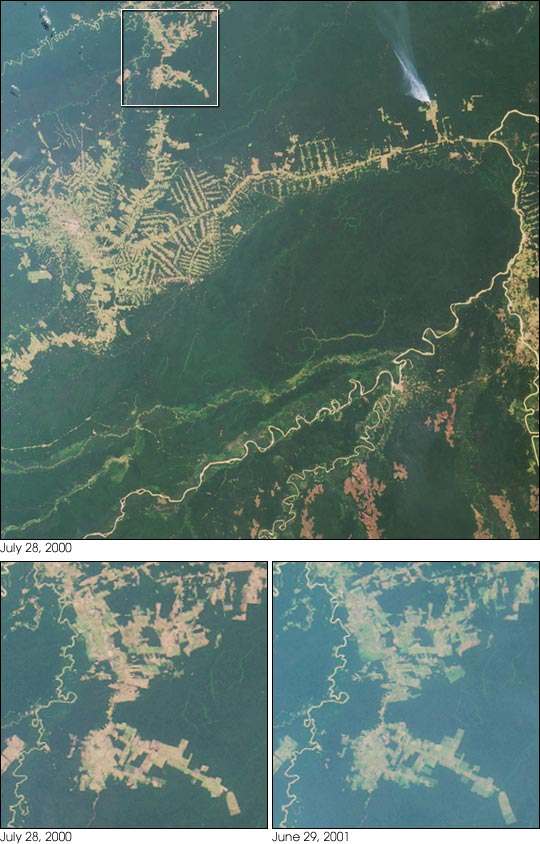
English: Settlement and deforestation surrounding the Brazilian town of Rio Branco are seen here in the striking "herring bone" deforestation patterns that cut through the rainforest.
Polski: Wylesianie strefy Rio Branco w Brazylii widziane z satelity. 10°6′31″S 67°33′9″W / 10.10861°S 67.5525°W / -10.10861; -67.5525 |
| Source | |
| Author |
NASA/GSFC/LaRC/JPL, MISR Team ,przeniósł na Commons Dobrzejest, wikipedia.pl : Adi4000[1] |
This image or video was catalogued by Jet Propulsion Laboratory of the United States National Aeronautics and Space Administration (NASA) under Photo ID: PIA03427. This tag does not indicate the copyright status of the attached work. A normal copyright tag is still required. See Commons:Licensing. Other languages:
العربية ∙ беларуская (тарашкевіца) ∙ български ∙ català ∙ čeština ∙ dansk ∙ Deutsch ∙ English ∙ español ∙ فارسی ∙ français ∙ galego ∙ magyar ∙ հայերեն ∙ Bahasa Indonesia ∙ italiano ∙ 日本語 ∙ македонски ∙ മലയാളം ∙ Nederlands ∙ polski ∙ português ∙ русский ∙ sicilianu ∙ slovenščina ∙ Türkçe ∙ українська ∙ 简体中文 ∙ 繁體中文 ∙ +/− |
Licensing
| Public domainPublic domainfalsefalse |
| This file is in the public domain in the United States because it was solely created by NASA. NASA copyright policy states that "NASA material is not protected by copyright unless noted". (See Template:PD-USGov, NASA copyright policy page or JPL Image Use Policy.) | ||
 |
Warnings:
|
Captions
Add a one-line explanation of what this file represents
Qué pasó Gabo Qué pasógfdergcwruk.
Items portrayed in this file
depicts
File history
Click on a date/time to view the file as it appeared at that time.
| Date/Time | Thumbnail | Dimensions | User | Comment | |
|---|---|---|---|---|---|
| current | 03:48, 5 April 2008 | | 540 × 844 (87 KB) | Adi | {{Information |Description=Wylesianie strefy Rio Branco w Brazylii widziane z satelity. |Source=[http://veimages.gsfc.nasa.gov/2180/PIA03427.jpg] |Date=3 kwietnia 2008 |Author=NASA Przeniósł na Commons Dobrzejest, wikipedia.pl : ''' |
File usage
The following pages on the English Wikipedia use this file (pages on other projects are not listed):
Global file usage
The following other wikis use this file:
- Usage on ar.wikipedia.org
- Usage on be.wikipedia.org
- Usage on da.wikipedia.org
- Usage on eo.wikipedia.org
- Usage on es.wikipedia.org
- Usage on ha.wikipedia.org
- Usage on ig.wikipedia.org
- Usage on meta.wikimedia.org
- Usage on pl.wikipedia.org
- Usage on uk.wikipedia.org
- Usage on www.wikidata.org
- Usage on zh.wikipedia.org
Retrieved from "https://en.wikipedia.org/wiki/File:Deforestacja_RioBranco.jpg"