File:Deutschland_Übersichtskarte.png
From Wikipedia, the free encyclopedia
Size of this preview: 471 × 599 pixels. Other resolutions: 189 × 240 pixels | 377 × 480 pixels | 603 × 768 pixels | 805 × 1,024 pixels | 1,979 × 2,518 pixels.
Original file (1,979 × 2,518 pixels, file size: 7.01 MB, MIME type: image/png)
| This is a file from the Wikimedia Commons. Information from its description page there is shown below. Commons is a freely licensed media file repository. You can help. |
|
Summary
| DescriptionDeutschland Übersichtskarte.png |
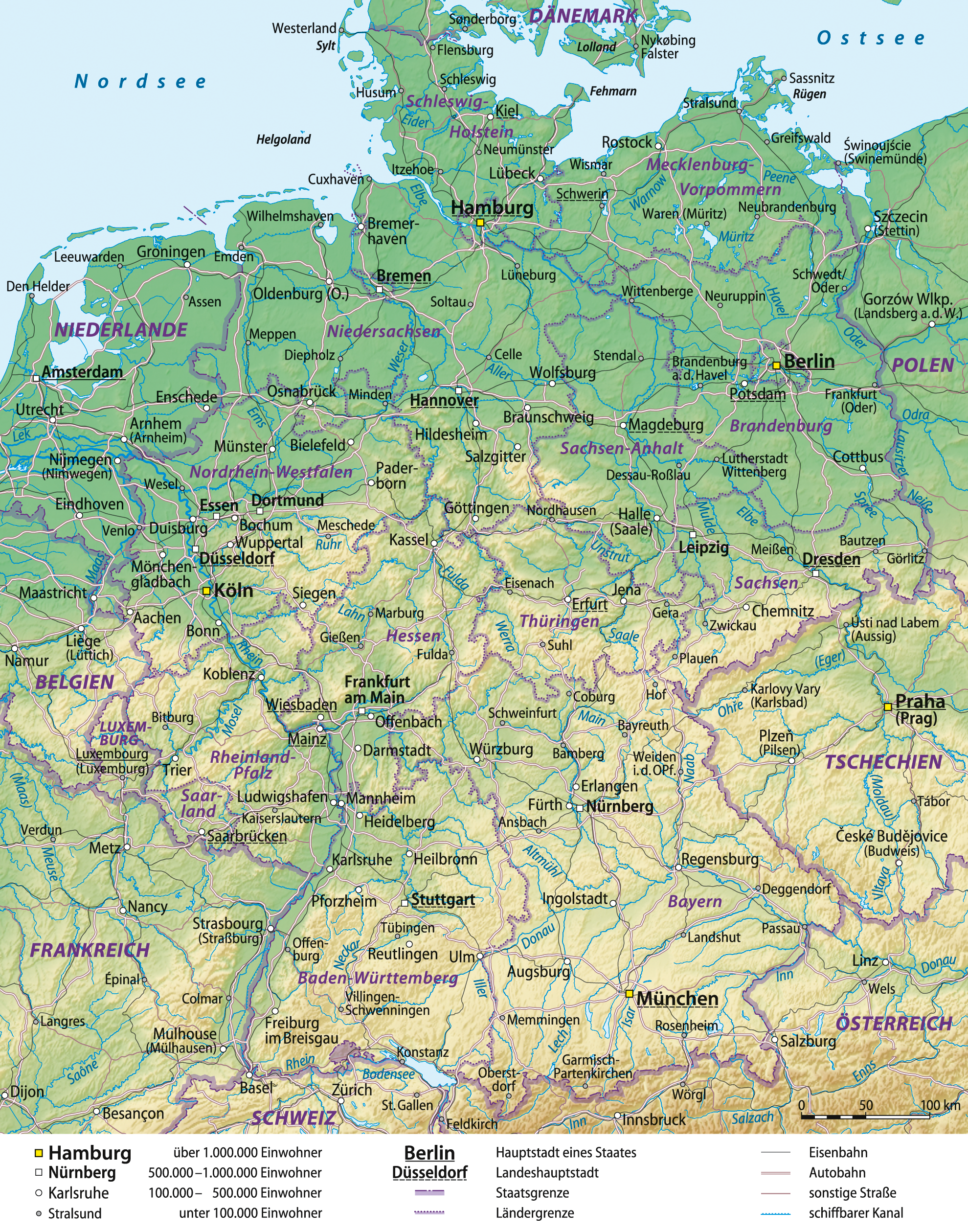
Deutsch: Übersichtskarte von Deutschland, deutsche Version
English: General map of Germany, German version
Français : Carte générale de l'Allemagne, en allemand
Español: Mapa general de Alemania, versión en alemán |
| Date | 03-06-2008 |
| Source |
self-made, using
|
| Author | Lencer and NordNordWest |
| Other versions |
|


|
This map has been made or improved in the German Kartenwerkstatt (Map Lab). You can propose maps to improve as well.
azərbaycanca ∙ čeština ∙ Deutsch ∙ Deutsch (Sie-Form) ∙ English ∙ español ∙ français ∙ italiano ∙ latviešu ∙ magyar ∙ Nederlands ∙ Plattdüütsch ∙ polski ∙ português ∙ română ∙ sicilianu ∙ slovenščina ∙ suomi ∙ македонски ∙ русский ∙ ქართული ∙ հայերեն ∙ বাংলা ∙ ไทย ∙ +/−
|
Licensing
I, the copyright holder of this work, hereby publish it under the following licenses:

|
Permission is granted to copy, distribute and/or modify this document under the terms of the GNU Free Documentation License, Version 1.2 or any later version published by the Free Software Foundation; with no Invariant Sections, no Front-Cover Texts, and no Back-Cover Texts. A copy of the license is included in the section entitled GNU Free Documentation License.http://www.gnu.org/copyleft/fdl.htmlGFDLGNU Free Documentation Licensetruetrue |
This file is licensed under the Creative Commons Attribution-Share Alike 3.0 Unported license.
- You are free:
- to share – to copy, distribute and transmit the work
- to remix – to adapt the work
- Under the following conditions:
- attribution – You must give appropriate credit, provide a link to the license, and indicate if changes were made. You may do so in any reasonable manner, but not in any way that suggests the licensor endorses you or your use.
- share alike – If you remix, transform, or build upon the material, you must distribute your contributions under the same or compatible license as the original.
You may select the license of your choice.
Captions
Add a one-line explanation of what this file represents
Items portrayed in this file
depicts
File history
Click on a date/time to view the file as it appeared at that time.
| Date/Time | Thumbnail | Dimensions | User | Comment | |
|---|---|---|---|---|---|
| current | 16:41, 29 December 2012 | | 1,979 × 2,518 (7.01 MB) | NordNordWest | update |
| 07:48, 29 July 2009 |  | 1,979 × 2,518 (6.8 MB) | NordNordWest | ||
| 19:05, 10 September 2008 |  | 1,979 × 2,521 (7.01 MB) | NordNordWest | Autobahnen aktualisiert | |
| 14:01, 16 June 2008 |  | 1,979 × 2,521 (6.82 MB) | NordNordWest | ||
| 16:17, 11 June 2008 |  | 1,978 × 2,521 (6.82 MB) | NordNordWest | kleinere Korrekturen | |
| 10:02, 6 June 2008 |  | 1,977 × 2,521 (6.8 MB) | NordNordWest | ||
| 14:30, 5 June 2008 |  | 1,978 × 2,521 (6.8 MB) | NordNordWest | ||
| 10:12, 5 June 2008 |  | 1,986 × 2,525 (6.8 MB) | NordNordWest | plus Grenzband | |
| 09:57, 5 June 2008 |  | 1,989 × 2,531 (6.79 MB) | NordNordWest | Korrekturen, mit Eisenbahn | |
| 16:31, 3 June 2008 |  | 1,987 × 2,527 (6.6 MB) | NordNordWest | {{Information |Description= {{de|Übersichtskarte von Deutschland}} {{en|General map of Germany}} |Source=self-made, using * Generic Mapping Tools * United States National Imagery and Mapp |
File usage
The following pages on the English Wikipedia use this file (pages on other projects are not listed):
Global file usage
The following other wikis use this file:
- Usage on avk.wikipedia.org
- Usage on be.wikipedia.org
- Usage on de.wikipedia.org
- Geographie Deutschlands
- Benutzer:Lencer
- Benutzer:Lencer/Galerie
- Wikipedia:Exzellente Bilder/Karten und Satellitenbilder
- Benutzer:Warboerde/Baustelle2
- Benutzer:NatiSythen/Karten
- Wikipedia:Kartenwerkstatt/Archiv/2008-06
- Wikipedia:Kartenwerkstatt/Hilfe/GMT/Gallery
- Wikipedia:Kandidaten für exzellente Bilder/Archiv2008/10
- Datei:Deutschland Übersichtskarte.png
- Benutzer:Lencer/Unterseite
- Benutzer:Uwe Dedering/Länderliste
- Benutzer:Ulflulfl/Karten
- Wikipedia:Kartenwerkstatt/Blog/3
- Wikipedia:Kartenwerkstatt/Archiv/Zurückgewiesene und zurückgestellte Aufträge 2009
- Wikipedia:Redaktion Bilder/Charts
- Wikipedia:Kartenwerkstatt/Schaufenster
- Museen in Deutschland
- Benutzer:Runologe/Landkarten
- Usage on fr.wikipedia.org
- Usage on it.wikipedia.org
- Usage on lb.wikipedia.org
- Usage on rm.wikipedia.org
- Usage on ru.wikipedia.org
- Usage on th.wikipedia.org
- Usage on tl.wikipedia.org
- Usage on tr.wikipedia.org
- Usage on uk.wikipedia.org
- Usage on uz.wikipedia.org
- Usage on wo.wikipedia.org
Metadata
This file contains additional information, probably added from the digital camera or scanner used to create or digitize it.
If the file has been modified from its original state, some details may not fully reflect the modified file.
| Horizontal resolution | 78.74 dpc |
|---|---|
| Vertical resolution | 78.74 dpc |
Retrieved from "https://en.wikipedia.org/wiki/File:Deutschland_Übersichtskarte.png"