File:Droysens-22-23.jpg
From Wikipedia, the free encyclopedia
Size of this preview: 732 × 600 pixels. Other resolutions: 293 × 240 pixels | 586 × 480 pixels | 937 × 768 pixels | 1,250 × 1,024 pixels | 2,499 × 2,048 pixels | 5,544 × 4,543 pixels.
Original file (5,544 × 4,543 pixels, file size: 4.44 MB, MIME type: image/jpeg)
| This is a file from the Wikimedia Commons. Information from its description page there is shown below. Commons is a freely licensed media file repository. You can help. |
The factual accuracy of this map or the file name is disputed.
Reason: Outdated; not according to current state of science |  |

|
File:Deutschland um das Jahr 1000.svg is a vector version of this file. It should be used in place of this JPG file when not inferior.
File:Droysens-22-23.jpg → File:Deutschland um das Jahr 1000.svg
For more information, see Help:SVG.
|
 |
Summary
| DescriptionDroysens-22-23.jpg |
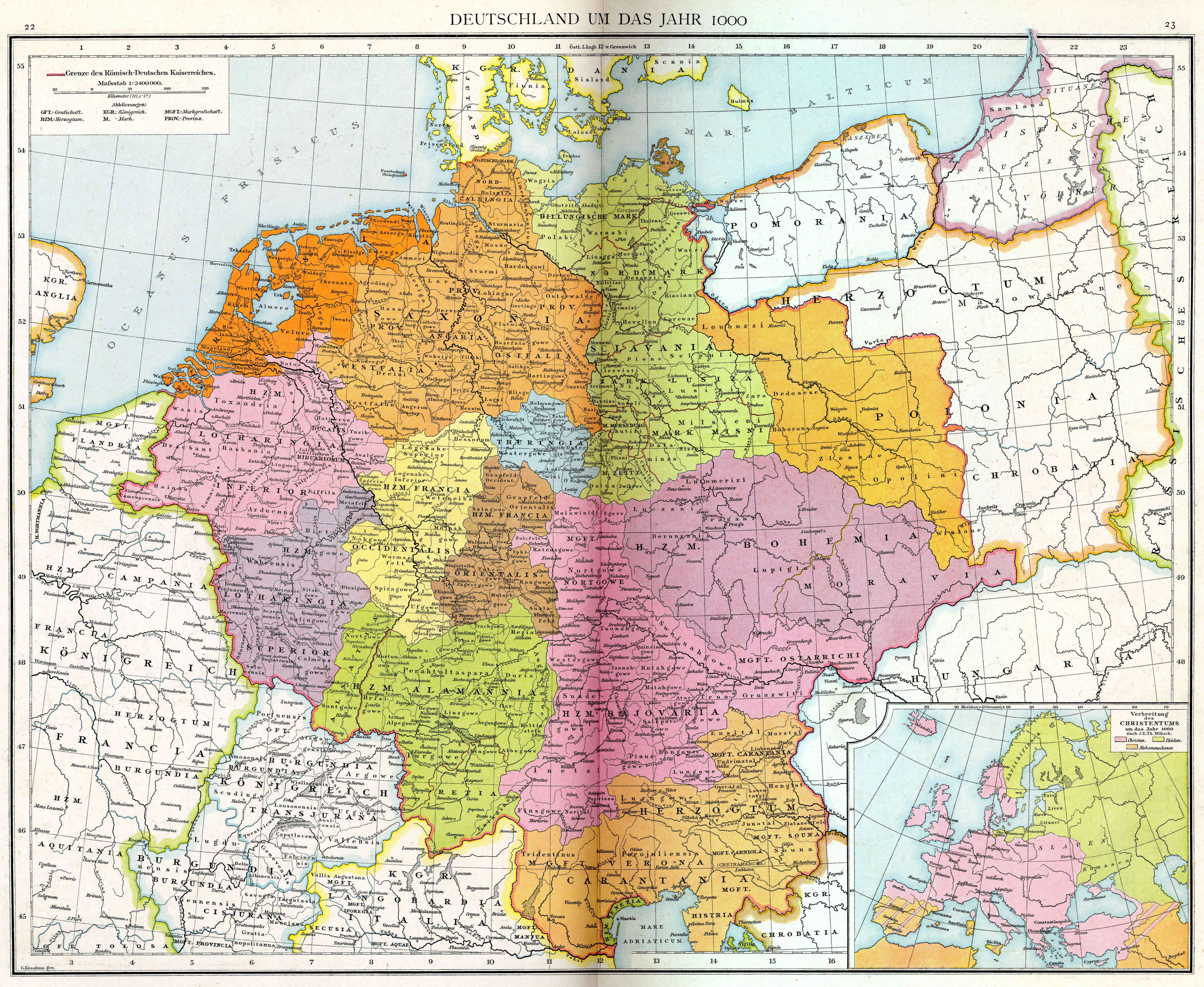
English: Plate 22 & 23 of Professor G. Droysens Allgemeiner Historischer Handatlas, published by R. Andrée. |
| Date | |
| Source | Own work |
| Author | Droysen/Andrée; G.Kossinna gez. |
Map is titled "Deutschland um das Jahr 1000".
Licensing
I, the copyright holder of this work, hereby publish it under the following licenses:
This file is licensed under the Creative Commons Attribution-Share Alike 3.0 Unported license.
- You are free:
- to share – to copy, distribute and transmit the work
- to remix – to adapt the work
- Under the following conditions:
- attribution – You must give appropriate credit, provide a link to the license, and indicate if changes were made. You may do so in any reasonable manner, but not in any way that suggests the licensor endorses you or your use.
- share alike – If you remix, transform, or build upon the material, you must distribute your contributions under the same or compatible license as the original.

|
Permission is granted to copy, distribute and/or modify this document under the terms of the GNU Free Documentation License, Version 1.2 or any later version published by the Free Software Foundation; with no Invariant Sections, no Front-Cover Texts, and no Back-Cover Texts. A copy of the license is included in the section entitled GNU Free Documentation License.http://www.gnu.org/copyleft/fdl.htmlGFDLGNU Free Documentation Licensetruetrue |
You may select the license of your choice.
Captions
Add a one-line explanation of what this file represents
Items portrayed in this file
depicts
1886
File history
Click on a date/time to view the file as it appeared at that time.
| Date/Time | Thumbnail | Dimensions | User | Comment | |
|---|---|---|---|---|---|
| current | 09:45, 1 September 2011 | | 5,544 × 4,543 (4.44 MB) | Maproom | {{Information |Description ={{en|1=Plate 22 & 23 of Professor G. Droysens Allgemeiner Historischer Handatlas, published by R. Andrée.}} |Source ={{own}} |Author =Maproom |Date =Published 1886, scanned 2004 |P |
File usage
The following pages on the English Wikipedia use this file (pages on other projects are not listed):
Global file usage
The following other wikis use this file:
- Usage on de.wikipedia.org
- Usage on el.wikipedia.org
- Usage on et.wikipedia.org
- Usage on uk.wikipedia.org
Metadata
This file contains additional information, probably added from the digital camera or scanner used to create or digitize it.
If the file has been modified from its original state, some details may not fully reflect the modified file.
| _error | 0 |
|---|
Retrieved from "https://en.wikipedia.org/wiki/File:Droysens-22-23.jpg"