File:FAA_JFK_Airport_map_2019.png
From Wikipedia, the free encyclopedia

Size of this preview: 800 × 598 pixels. Other resolutions: 320 × 239 pixels | 640 × 479 pixels | 1,024 × 766 pixels | 1,126 × 842 pixels.
Original file (1,126 × 842 pixels, file size: 311 KB, MIME type: image/png)
| This is a file from the Wikimedia Commons. Information from its description page there is shown below. Commons is a freely licensed media file repository. You can help. |
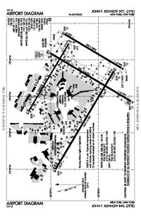
Summary
| DescriptionFAA JFK Airport map 2019.png |
English: JFK Airport map, 2019
日本語: JFK空港の地図です |
| Date | |
| Source | FAA |
| Author |
Federal Aviation Administration; converted to png-file by Kontrollstelle Kundl, on 31 July 2023 |
| Other versions |
 |
| Camera location | 40° 39′ 00″ N, 73° 48′ 00″ W | View this and other nearby images on: OpenStreetMap |
|---|
Licensing
| Public domainPublic domainfalsefalse |
This image or file is a work of a Federal Aviation Administration employee, taken or made as part of that person's official duties. As a work of the U.S. federal government, the image is in the public domain in the United States.
English | italiano | македонски | മലയാളം | Nederlands | русский | sicilianu | українська | 中文 | +/− |
 |
Captions
Add a one-line explanation of what this file represents
Items portrayed in this file
depicts
23 May 2019
40°39'0"N, 73°48'0"W
image/png
File history
Click on a date/time to view the file as it appeared at that time.
| Date/Time | Thumbnail | Dimensions | User | Comment | |
|---|---|---|---|---|---|
| current | 17:01, 31 July 2023 | | 1,126 × 842 (311 KB) | Kontrollstellekundl | {{Rename|1=FAA JFK Airport map 2019.pdf|2=4|3=|user=Kontrollstellekundl}} =={{int:filedesc}}== {{Information |description = {{en|1=JFK Airport map, 2019}} {{ja|1=JFK空港の地図です}} |date = 2019-05-23 |source = [https://aeronav.faa.gov/d-tpp/1906/00610ad.pdf#nameddest=(JFK) FAA] |author = {{label|Q335357}};<br />converted to png-file by Kontrollstelle Kundl, {{date|2023-07-31}} |permission= |other versions= [[file:KJFK Airport Diagram 2019ver.pdf|thumb|2... |
File usage
The following pages on the English Wikipedia use this file (pages on other projects are not listed):
Global file usage
The following other wikis use this file:
- Usage on ban.wikipedia.org
- Usage on cs.wikipedia.org
- Usage on de.wikipedia.org
- Usage on es.wikipedia.org
- Usage on zh.wikipedia.org
Metadata
This file contains additional information, probably added from the digital camera or scanner used to create or digitize it.
If the file has been modified from its original state, some details may not fully reflect the modified file.
| Horizontal resolution | 41.73 dpc |
|---|---|
| Vertical resolution | 41.73 dpc |
Retrieved from "https://en.wikipedia.org/wiki/File:FAA_JFK_Airport_map_2019.png"