File:Galapagos-satellite-2002.jpg
From Wikipedia, the free encyclopedia
Size of this preview: 800 × 600 pixels. Other resolutions: 320 × 240 pixels | 640 × 480 pixels | 1,024 × 768 pixels | 1,280 × 960 pixels | 1,600 × 1,200 pixels.
Original file (1,600 × 1,200 pixels, file size: 387 KB, MIME type: image/jpeg)
| This is a file from the Wikimedia Commons. Information from its description page there is shown below. Commons is a freely licensed media file repository. You can help. |
Summary
| DescriptionGalapagos-satellite-2002.jpg |
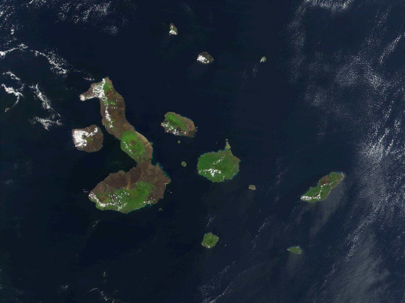
English: This true-color image of the Galapagos Islands was acquired on March 12, 2002, by the Moderate-resolution Imaging Spectroradiometer (MODIS), flying aboard NASA's Terra satellite. The Galapagos Islands, which are part of Ecuador, sit in the Pacific Ocean about 1000 km (620 miles) west of South America. As the three craters on the largest island (Isabela Island) suggest, the archipelago was created by volcanic eruptions, which took place millions of years ago. |
| Date | |
| Source | Earth Observatory 8270 and NASA GSFC |
| Author | Jacques Descloitres, MODIS Rapid Response Project at NASA/GSFC |
Licensing
| Public domainPublic domainfalsefalse |
| This file is in the public domain in the United States because it was solely created by NASA. NASA copyright policy states that "NASA material is not protected by copyright unless noted". (See Template:PD-USGov, NASA copyright policy page or JPL Image Use Policy.) | ||
 |
Warnings:
|
| Annotations InfoField | This image is annotated: View the annotations at Commons |
646
82
84
76
1600
1200
Pinta
760
186
100
98
1600
1200
Marchena
1016
208
52
62
1600
1200
Genovesa
624
432
166
130
1600
1200
San Salvador (Santiago)
690
552
40
30
1600
1200
Rábida
698
622
60
60
1600
1200
Pinzón
762
888
136
126
1600
1200
Floreana
262
484
154
138
1600
1200
Fernandina
972
724
52
48
1600
1200
Santa Fé
1170
666
200
162
1600
1200
San Cristóbal
1118
958
92
70
1600
1200
Española
772
590
184
148
1600
1200
Santa Cruz
282
292
398
568
1600
1200
Isabela
876
566
54
46
1600
1200
Baltra (Seymour Sur)
608
812
50
58
1600
1200
Tortuga
882
546
38
26
1600
1200
Seymour Norte
946
630
20
30
1600
1200
Plaza Sur
842
552
34
36
1600
1200
Daphne Mayor
244
272
26
32
1600
1200
Roca Redonda
Captions
The Galapagos islands
Die Galapagosinseln
Items portrayed in this file
depicts
12 March 2002
File history
Click on a date/time to view the file as it appeared at that time.
| Date/Time | Thumbnail | Dimensions | User | Comment | |
|---|---|---|---|---|---|
| current | 21:13, 25 November 2007 | | 1,600 × 1,200 (387 KB) | CarolSpears | {{Information |Description= This true-color image of the Galapagos Islands was acquired on March 12, 2002, by the Moderate-resolution Imaging Spectroradiometer (MODIS), flying aboard NASA's Terra satellite. The Galapagos Islands, which are part of Ecuador |
File usage
The following pages on the English Wikipedia use this file (pages on other projects are not listed):
Global file usage
The following other wikis use this file:
- Usage on af.wikipedia.org
- Usage on als.wikipedia.org
- Usage on an.wikipedia.org
- Usage on ast.wikipedia.org
- Usage on azb.wikipedia.org
- Usage on bg.wikipedia.org
- Usage on bn.wikipedia.org
- Usage on br.wikipedia.org
- Usage on ca.wikipedia.org
- Usage on cs.wikipedia.org
- Usage on de.wikipedia.org
- Usage on de.wikinews.org
- Usage on en.wikivoyage.org
- Usage on en.wiktionary.org
- Usage on eo.wikipedia.org
- Usage on es.wikipedia.org
- Usage on frr.wikipedia.org
- Usage on fr.wikipedia.org
- Usage on hu.wikipedia.org
- Usage on hy.wikipedia.org
- Usage on incubator.wikimedia.org
- Usage on it.wikipedia.org
- Usage on ja.wikipedia.org
- Usage on jv.wikipedia.org
View more global usage of this file.
Metadata
This file contains additional information, probably added from the digital camera or scanner used to create or digitize it.
If the file has been modified from its original state, some details may not fully reflect the modified file.
| _error | 0 |
|---|
Retrieved from "https://en.wikipedia.org/wiki/File:Galapagos-satellite-2002.jpg"