File:Geographic_Map_of_Mexico.jpg
From Wikipedia, the free encyclopedia
Size of this preview: 800 × 564 pixels. Other resolutions: 320 × 226 pixels | 640 × 451 pixels | 1,024 × 722 pixels.
Original file (1,024 × 722 pixels, file size: 455 KB, MIME type: image/jpeg)
| This is a file from the Wikimedia Commons. Information from its description page there is shown below. Commons is a freely licensed media file repository. You can help. |
Summary
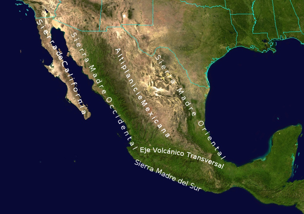
| DescriptionGeographic Map of Mexico.jpg |
English: Topological Map labeling the most important elevations of the country |
| Date | |
| Source | NASA |
| Author | NASA - derivative work by Ricraider |
Licensing
| Public domainPublic domainfalsefalse |
| This file is in the public domain in the United States because it was solely created by NASA. NASA copyright policy states that "NASA material is not protected by copyright unless noted". (See Template:PD-USGov, NASA copyright policy page or JPL Image Use Policy.) | ||
 |
Warnings:
|
Original upload log
The original description page was here. All following user names refer to en.wikipedia.
- 2010-08-24 02:05 Ricraider 1024×722× (465741 bytes) {{Information |Description = Topological Map labeling the most important elevations of the country |Source = NASA |Date = 8-23-10 |Author = ricraider |Permission = |other_versions = }}
Captions
Add a one-line explanation of what this file represents
Items portrayed in this file
depicts
File history
Click on a date/time to view the file as it appeared at that time.
| Date/Time | Thumbnail | Dimensions | User | Comment | |
|---|---|---|---|---|---|
| current | 09:02, 21 December 2012 | | 1,024 × 722 (455 KB) | Urdangaray | {{Information |Description={{en|Topological Map labeling the most important elevations of the country}} |Source=Transferred from [http://en.wikipedia.org en.wikipedia]<br/> (Original text : ''NASA'') |Date=8-23-10<br/> ({{Original upload date|2010-08-2... |
File usage
The following pages on the English Wikipedia use this file (pages on other projects are not listed):
Global file usage
The following other wikis use this file:
- Usage on bs.wikipedia.org
- Usage on cs.wikipedia.org
- Usage on de.wikipedia.org
- Usage on es.wikipedia.org
- Usage on eu.wikipedia.org
- Usage on fa.wikipedia.org
- Usage on is.wikipedia.org
- Usage on ja.wikipedia.org
- Usage on nn.wikipedia.org
- Usage on no.wikipedia.org
- Usage on pl.wikipedia.org
- Usage on simple.wikipedia.org
- Usage on sk.wikipedia.org
- Usage on sv.wikipedia.org
- Usage on tr.wikipedia.org
- Usage on uk.wikipedia.org
- Usage on zh.wikipedia.org
Metadata
This file contains additional information, probably added from the digital camera or scanner used to create or digitize it.
If the file has been modified from its original state, some details may not fully reflect the modified file.
| Orientation | Normal |
|---|---|
| Horizontal resolution | 72 dpi |
| Vertical resolution | 72 dpi |
| Software used | Adobe Photoshop CS4 Macintosh |
| File change date and time | 20:55, 23 August 2010 |
| Color space | sRGB |
| Image width | 1,024 px |
| Image height | 722 px |
| Date metadata was last modified | 15:55, 23 August 2010 |
| Date and time of digitizing | 15:37, 23 August 2010 |
| Unique ID of original document | xmp.did:03801174072068118DBBF0C7378BE1EE |
Retrieved from "https://en.wikipedia.org/wiki/File:Geographic_Map_of_Mexico.jpg"