File:Geostationaryjava3Dsideview.gif
From Wikipedia, the free encyclopedia
No higher resolution available.
Geostationaryjava3Dsideview.gif (220 × 220 pixels, file size: 111 KB, MIME type: image/gif, looped, 163 frames, 12 s)
| This is a file from the Wikimedia Commons. Information from its description page there is shown below. Commons is a freely licensed media file repository. You can help. |
Summary
| DescriptionGeostationaryjava3Dsideview.gif |
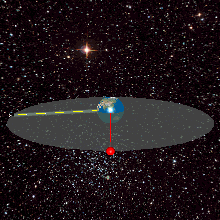
English: A geostationary orbit can only be achieved at an altitude very close to 35,786 km (22,236 mi), and directly above the equator. This equates to an orbital velocity of 3.07 km/s (1.91 mi/s) or a period of 1,436 minutes, which equates to almost exactly one sidereal day or 23.934461223 hours. This makes sense considering that the satellite must be locked to the Earth's rotational period in order to have a stationary footprint on the ground. In practice, this means that all geostationary satellites have to exist on this ring http://weelookang.blogspot.com/2010/07/ejs-open-source-geostationary-satellite.html |
| Date | |
| Source | Own work |
| Author | Lookang many thanks to author of original simulation = Francisco Esquembre author of Easy Java Simulation = Francisco Esquembre |
| Permission (Reusing this file) |
I, the copyright holder of this work, hereby publish it under the following license: This file is licensed under the Creative Commons Attribution-Share Alike 3.0 Unported license.
|
Captions
Add a one-line explanation of what this file represents
Items portrayed in this file
depicts
some value
27 June 2011
File history
Click on a date/time to view the file as it appeared at that time.
| Date/Time | Thumbnail | Dimensions | User | Comment | |
|---|---|---|---|---|---|
| current | 05:04, 12 June 2013 | | 220 × 220 (111 KB) | Lookang | updated earth texture with public domain better resolution |
| 05:02, 12 June 2013 |  | 220 × 220 (420 KB) | Lookang | updated with public domain earth texture. radius of earth is proportional to geostationary orbit now | |
| 01:29, 27 June 2011 |  | 220 × 220 (420 KB) | Lookang |
File usage
The following pages on the English Wikipedia use this file (pages on other projects are not listed):
Global file usage
The following other wikis use this file:
- Usage on ar.wikipedia.org
- Usage on ast.wikipedia.org
- Usage on bn.wikipedia.org
- Usage on ca.wikipedia.org
- Usage on eo.wikipedia.org
- Usage on es.wikipedia.org
- Usage on es.wikiversity.org
- Usage on et.wikipedia.org
- Usage on fa.wikipedia.org
- Usage on fr.wikipedia.org
- Usage on gl.wikipedia.org
- Usage on he.wikipedia.org
- Usage on hi.wikipedia.org
- Usage on hu.wikipedia.org
- Usage on ml.wikipedia.org
- Usage on ms.wikipedia.org
- Usage on no.wikipedia.org
- Usage on pl.wikipedia.org
- Usage on pt.wikipedia.org
- Usage on ru.wikipedia.org
- Usage on simple.wikipedia.org
- Usage on ta.wikipedia.org
- Usage on te.wikipedia.org
- Usage on tg.wikipedia.org
- Usage on th.wikipedia.org
- Usage on uk.wikipedia.org
- Usage on zh.wikipedia.org
Metadata
This file contains additional information, probably added from the digital camera or scanner used to create or digitize it.
If the file has been modified from its original state, some details may not fully reflect the modified file.
| GIF file comment | Title: geostationayJav3d2013side Author: lookang |
|---|
Retrieved from "https://en.wikipedia.org/wiki/File:Geostationaryjava3Dsideview.gif"