File:Germany1941.png
From Wikipedia, the free encyclopedia
No higher resolution available.
Germany1941.png (698 × 600 pixels, file size: 240 KB, MIME type: image/png)
| This is a file from the Wikimedia Commons. Information from its description page there is shown below. Commons is a freely licensed media file repository. You can help. |
Summary
| DescriptionGermany1941.png |
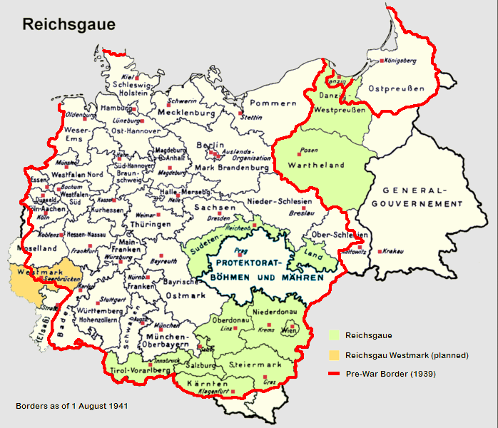
English: Reichsgaue and Generalgouvernement in June 1941
Deutsch: Reichsgaue und Generalgouvernement im Jahre 1941.
Français : La Pologne démembrée dans l'Europe allemande.
Polski: Aneksje III Rzeszy w czasie II wojny światowej (do sierpnia 1941), linia czerwona pokazuje przebieg granicy państwowej Rzeszy 1 września 1939 (wyodrębnione również Wolne Miasto Gdańsk). Aneksje terytorialne III Rzeszy do sierpnia 1941,linia czerwona - przebieg granicy państwowej Niemiec 1 września 1939. Wyodrębniony teren Generalnego Gubernatorstwa. III Rzesza oraz terytoria anektowane i Generalne Gubernatorstwo w sierpniu 1941, linia czerwona pokazuje przebieg granicy Niemiec 1 września 1939. Aneksje III Rzeszy w czasie II wojny światowej (do sierpnia 1941), linia czerwona pokazuje przebieg granicy państwowej Rzeszy 1 września 1939 (wyodrębnione również Wolne Miasto Gdańsk).
Italiano: Il Reichsgau e il Governatorato Generale nel 1941.
Nederlands: Reichsgaue en het Gouvernement-Generaal in 1941.
Español: Mapa de Alemania en 1941, sobre el este (derecha del mapa) el Gobierno General.
中文(简体):1941年的纳粹德国,包括帝国大区与被吞并的波兰总督府。
中文(繁體):1941年的納粹德國,包括帝國大區與被吞併的波蘭總督府。
Norsk bokmål: Kart over Reichsgau i 1941.
Čeština: Generální gouvernement na mapě Třetí říše.
Tiếng Việt: Nước Đức năm 1941, bao gồm lãnh thổ của Ba Lan bị chiếm đóng. |
| Source |
|
| Author | Morty, Mackler, Lucius1976 |
| Other versions | de:Bild:Reichsgaue.png |
Licensing

|
Permission is granted to copy, distribute and/or modify this document under the terms of the GNU Free Documentation License, Version 1.2 or any later version published by the Free Software Foundation; with no Invariant Sections, no Front-Cover Texts, and no Back-Cover Texts. A copy of the license is included in the section entitled GNU Free Documentation License.http://www.gnu.org/copyleft/fdl.htmlGFDLGNU Free Documentation Licensetruetrue |
| This file is licensed under the Creative Commons Attribution-Share Alike 3.0 Unported license. | ||
| ||
| This licensing tag was added to this file as part of the GFDL licensing update.http://creativecommons.org/licenses/by-sa/3.0/CC BY-SA 3.0Creative Commons Attribution-Share Alike 3.0truetrue |
Captions
Add a one-line explanation of what this file represents
Items portrayed in this file
depicts
image/png
File history
Click on a date/time to view the file as it appeared at that time.
| Date/Time | Thumbnail | Dimensions | User | Comment | |
|---|---|---|---|---|---|
| current | 20:32, 9 June 2017 | | 698 × 600 (240 KB) | Hohum | Clearer colouring |
| 14:08, 25 February 2011 |  | 698 × 600 (279 KB) | Morgan Hauser | *Bohemia-Moravia was already integrated into the Third Reich before the outbreak of the war. *General fixes. | |
| 15:52, 6 September 2006 |  | 698 × 600 (274 KB) | Ernalve | Map of Germany in 1941 - Mapa de Alemania en 1941 GFDL from from [http://en.wikipedia.org/wiki/Image:Germany1941.png] Licencia GFDL, tomado de [http://en.wikipedia.org/wiki/Image:Germany1941.png]. |
File usage
The following pages on the English Wikipedia use this file (pages on other projects are not listed):
Global file usage
The following other wikis use this file:
- Usage on an.wikipedia.org
- Usage on ar.wikipedia.org
- Usage on ca.wikipedia.org
- Usage on cs.wikipedia.org
- Usage on de.wikipedia.org
- Usage on es.wikipedia.org
- Usage on fa.wikipedia.org
- Usage on fr.wikipedia.org
- Usage on hy.wikipedia.org
- Usage on id.wikipedia.org
- Usage on it.wikipedia.org
- Usage on ja.wikipedia.org
- Usage on lt.wikipedia.org
- Usage on nl.wikipedia.org
- Usage on no.wikipedia.org
- Usage on pt.wikipedia.org
- Usage on sh.wikipedia.org
- Usage on sr.wikipedia.org
- Usage on th.wikipedia.org
- Usage on tr.wikipedia.org
- Usage on uk.wikipedia.org
- Usage on vi.wikipedia.org
- Usage on zh.wikipedia.org
Metadata
This file contains additional information, probably added from the digital camera or scanner used to create or digitize it.
If the file has been modified from its original state, some details may not fully reflect the modified file.
| Horizontal resolution | 37.79 dpc |
|---|---|
| Vertical resolution | 37.79 dpc |
| File change date and time | 20:31, 9 June 2017 |
Retrieved from "https://en.wikipedia.org/wiki/File:Germany1941.png"