File:Holy_Cross_Church,_Ryton_-_geograph.org.uk_-_83165.jpg
From Wikipedia, the free encyclopedia
Size of this preview: 377 × 599 pixels. Other resolutions: 151 × 240 pixels | 403 × 640 pixels.
Original file (403 × 640 pixels, file size: 63 KB, MIME type: image/jpeg)
| This is a file from the Wikimedia Commons. Information from its description page there is shown below. Commons is a freely licensed media file repository. You can help. |
Summary
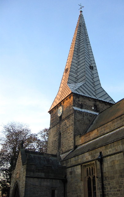
| DescriptionHoly Cross Church, Ryton - geograph.org.uk - 83165.jpg |
English: West tower and broach spire of Holy Cross parish church, Ryton, Tyne and Wear (formerly County Durham), seen from the southeast. The spire has a timber frame and lead roof. |
| Date | |
| Source | From geograph.org.uk |
| Author | Alan Fearon |
| Attribution (required by the license) InfoField | Alan Fearon / Holy Cross Church, Ryton / |
InfoField | Alan Fearon / Holy Cross Church, Ryton |
| Object location | 54° 58′ 41″ N, 1° 45′ 58″ W | View this and other nearby images on: OpenStreetMap |
|---|
Licensing

|
This image was taken from the Geograph project collection. See this photograph's page on the Geograph website for the photographer's contact details. The copyright on this image is owned by Alan Fearon and is licensed for reuse under the Creative Commons Attribution-ShareAlike 2.0 license.
|
This file is licensed under the Creative Commons Attribution-Share Alike 2.0 Generic license.
Attribution: Alan Fearon
- You are free:
- to share – to copy, distribute and transmit the work
- to remix – to adapt the work
- Under the following conditions:
- attribution – You must give appropriate credit, provide a link to the license, and indicate if changes were made. You may do so in any reasonable manner, but not in any way that suggests the licensor endorses you or your use.
- share alike – If you remix, transform, or build upon the material, you must distribute your contributions under the same or compatible license as the original.
Captions
Add a one-line explanation of what this file represents
Items portrayed in this file
depicts
some value
21 November 2005
54°58'40.8"N, 1°45'57.6"W
File history
Click on a date/time to view the file as it appeared at that time.
| Date/Time | Thumbnail | Dimensions | User | Comment | |
|---|---|---|---|---|---|
| current | 21:51, 30 January 2010 | | 403 × 640 (63 KB) | GeographBot | == {{int:filedesc}} == {{Information |description={{en|1=Holy Cross Church, Ryton. The church is situated in the west of the village and is the oldest building in Ryton, dating back to 1220. The Architecture of the Church is Gothic, and the spire towers |
File usage
The following pages on the English Wikipedia use this file (pages on other projects are not listed):
Global file usage
The following other wikis use this file:
- Usage on arz.wikipedia.org
- Usage on cy.wikipedia.org
- Usage on fa.wikipedia.org
- Usage on fr.wikipedia.org
- Usage on it.wikipedia.org
- Usage on lld.wikipedia.org
- Usage on pl.wikipedia.org
- Usage on www.wikidata.org
Metadata
This file contains additional information, probably added from the digital camera or scanner used to create or digitize it.
If the file has been modified from its original state, some details may not fully reflect the modified file.
| _error | 0 |
|---|