File:Karte-Haus-Burgund_4-FR.png
From Wikipedia, the free encyclopedia
Size of this preview: 426 × 600 pixels. Other resolutions: 170 × 240 pixels | 341 × 480 pixels | 545 × 768 pixels | 727 × 1,024 pixels | 2,500 × 3,521 pixels.
Original file (2,500 × 3,521 pixels, file size: 1.34 MB, MIME type: image/png)
| This is a file from the Wikimedia Commons. Information from its description page there is shown below. Commons is a freely licensed media file repository. You can help. |
Summary
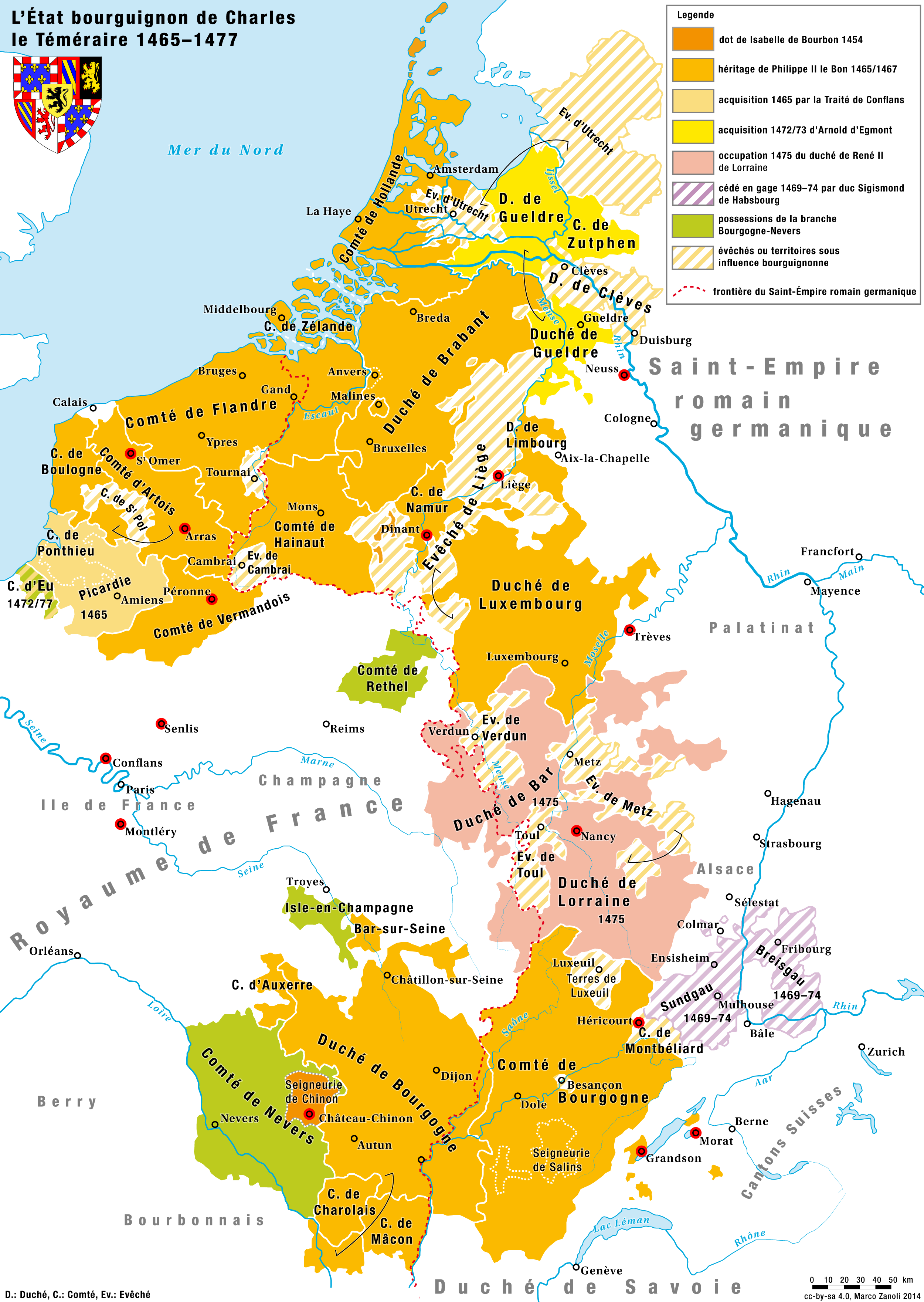
| DescriptionKarte-Haus-Burgund 4-FR.png |
Deutsch: Das Herrschaftsgebiet des Hauses Burgund unter Karl I., dem Kühnen 1465/67–1477 Français : L'État bourguignon de Charles le Téméraire 1465–1477 |
| Date | |
| Source | Own work |
| Author | Marco Zanoli (sidonius (talk) 17:11, 2 March 2014 (UTC)) |
| Other versions |
|


Licensing
You may use my work outside wikipedia for free as long as you name me as the author. If you would like to use my work in a print medium, please send me a specimen copy.
Contact me if you have questions regarding the license or if you want individual changes to the map (marco.zanoli at hotmail.ch). This file is licensed under the Creative Commons Attribution-Share Alike 4.0 International license. Attribution: Marco Zanoli
|
Captions
Add a one-line explanation of what this file represents
L’État bourguignon de Charles le Téméraire 1465–1477
Items portrayed in this file
depicts
2 March 2014
image/png
File history
Click on a date/time to view the file as it appeared at that time.
| Date/Time | Thumbnail | Dimensions | User | Comment | |
|---|---|---|---|---|---|
| current | 09:28, 23 August 2023 | | 2,500 × 3,521 (1.34 MB) | Sidonius | earlier corrections adapted (thanks) and further adaptations to the other versions in DE and EN |
| 21:10, 19 December 2021 |  | 1,200 × 1,737 (584 KB) | 1Loupdesbois | Autres corrections (Ile de France, Hainaut) | |
| 16:39, 19 December 2021 |  | 1,200 × 1,737 (584 KB) | 1Loupdesbois | Traductions et corrections (Dole, Cambrai, Hollande, Flandre, La Haye) | |
| 17:07, 2 March 2014 |  | 1,200 × 1,737 (510 KB) | Sidonius | User created page with UploadWizard |
File usage
The following pages on the English Wikipedia use this file (pages on other projects are not listed):
Global file usage
The following other wikis use this file:
- Usage on ast.wikipedia.org
- Usage on bg.wikipedia.org
- Usage on de.wikipedia.org
- Usage on eo.wikipedia.org
- Usage on fr.wikipedia.org
- Belgique
- Duché de Bourgogne
- Charles le Téméraire
- Histoire du Nord-Pas-de-Calais
- Royaume de Bourgogne (534-843)
- État bourguignon
- Pays-Bas bourguignons
- Histoire de la Franche-Comté
- Guerres de Bourgogne
- Comté de Bourgogne
- Royaume de Provence
- Royaume de Haute-Bourgogne
- Maison natale de Jeanne d'Arc
- Royaume d'Arles
- Histoire de la Bourgogne
- Antoine du Bois
- Réveillez-vous Picards
- Bourgogne-Franche-Comté
- Sac de Dinant (1466)
- Bibliothèque des ducs de Bourgogne
- Royaume de Bourgogne
- Entrevue de Trèves
- Usage on fr.wikiversity.org
- Usage on hy.wikipedia.org
- Usage on pcd.wikipedia.org
- Usage on pl.wikipedia.org
- Usage on ro.wikipedia.org
- Usage on sr.wikipedia.org
- Usage on uk.wikipedia.org
- Usage on zh.wikipedia.org
Metadata
This file contains additional information, probably added from the digital camera or scanner used to create or digitize it.
If the file has been modified from its original state, some details may not fully reflect the modified file.
| Copyright holder |
|
|---|---|
| Image title |
|
| Software used |
Retrieved from "https://en.wikipedia.org/wiki/File:Karte-Haus-Burgund_4-FR.png"