File:Kingston-plant-spill-swanpond-tn2.jpg
From Wikipedia, the free encyclopedia
Size of this preview: 800 × 600 pixels. Other resolutions: 320 × 240 pixels | 640 × 480 pixels | 1,024 × 768 pixels | 1,280 × 960 pixels | 2,048 × 1,536 pixels.
Original file (2,048 × 1,536 pixels, file size: 992 KB, MIME type: image/jpeg)
| This is a file from the Wikimedia Commons. Information from its description page there is shown below. Commons is a freely licensed media file repository. You can help. |
Summary
| DescriptionKingston-plant-spill-swanpond-tn2.jpg |
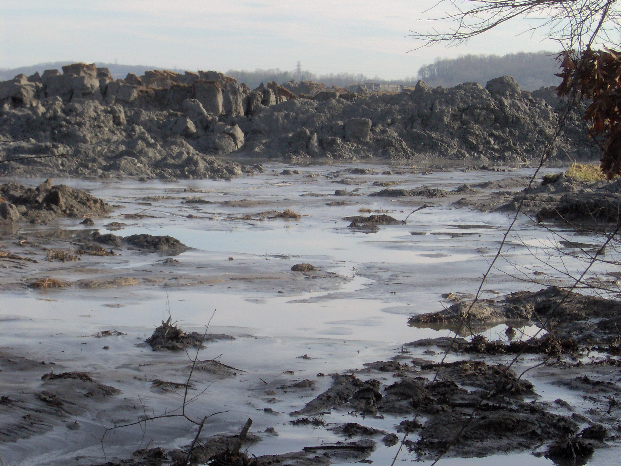
English: View of the TVA Kingston Fossil Plant fly ash spill, appx. 1 mile from the retention pond. This view is from just off Swan Pond Road. The pile of ash in the photo is 20-25 feet high, and stretches for two miles or so along this inlet (the inlet empties into the Emory River).
Appx. coordinates: N 35.92087 W 84.51701 |
| Date | |
| Source | Own work |
| Author | Brian Stansberry |
| Camera location | 35° 55′ 15.13″ N, 84° 31′ 01.24″ W | View this and other nearby images on: OpenStreetMap |
|---|
Licensing
I, the copyright holder of this work, hereby publish it under the following license:
This file is licensed under the Creative Commons Attribution 3.0 Unported license.
- You are free:
- to share – to copy, distribute and transmit the work
- to remix – to adapt the work
- Under the following conditions:
- attribution – You must give appropriate credit, provide a link to the license, and indicate if changes were made. You may do so in any reasonable manner, but not in any way that suggests the licensor endorses you or your use.
Captions
Add a one-line explanation of what this file represents
Items portrayed in this file
depicts
some value
27 December 2008
35°55'15.13"N, 84°31'1.24"W
File history
Click on a date/time to view the file as it appeared at that time.
| Date/Time | Thumbnail | Dimensions | User | Comment | |
|---|---|---|---|---|---|
| current | 01:18, 28 December 2008 | | 2,048 × 1,536 (992 KB) | BrineStans | {{Information |Description={{en|1=View of the TVA Kingston Fossil Plant fly ash spill, appx. 1 mile downstream from the retention pond. This view is from just off Swan Pond Road. The pile of ash in the photo is 20-25 feet high, and stretches for two mil |
File usage
The following pages on the English Wikipedia use this file (pages on other projects are not listed):
Global file usage
The following other wikis use this file:
- Usage on ar.wikipedia.org
- Usage on cs.wikipedia.org
- Usage on en.wikiquote.org
- Usage on id.wikipedia.org
- Usage on zh.wikipedia.org
Metadata
This file contains additional information, probably added from the digital camera or scanner used to create or digitize it.
If the file has been modified from its original state, some details may not fully reflect the modified file.
| Image title | IM000109.JPG |
|---|---|
| Camera manufacturer | Hewlett-Packard |
| Camera model | Photosmart M305 |
| Copyright holder | Copyright 2003-2004 |
| Exposure time | 1/183 sec (0.0054644808743169) |
| F-number | f/8.029 |
| ISO speed rating | 100 |
| Date and time of data generation | 18:53, 16 July 2009 |
| Lens focal length | 17.25 mm |
| Orientation | Normal |
| Horizontal resolution | 72 dpi |
| Vertical resolution | 72 dpi |
| Software used | .06_NL |
| File change date and time | 18:53, 16 July 2009 |
| Y and C positioning | Co-sited |
| Exposure Program | Landscape mode (for landscape photos with the background in focus) |
| Exif version | 2.2 |
| Date and time of digitizing | 18:53, 16 July 2009 |
| Image compression mode | 2.583989461263 |
| Shutter speed | 7.516 |
| APEX aperture | 6.01 |
| Exposure bias | 0 |
| Maximum land aperture | 3.082 APEX (f/2.91) |
| Subject distance | 30 meters |
| Metering mode | Average |
| Light source | Unknown |
| Flash | Flash did not fire, compulsory flash suppression |
| Color space | sRGB |
| Digital zoom ratio | 1 |
| Scene capture type | Landscape |
| Contrast | Normal |
| Saturation | Normal |
| Sharpness | Hard |
| Subject distance range | Distant view |