File:Map_of_Trialetian.png
From Wikipedia, the free encyclopedia
Size of this preview: 800 × 562 pixels. Other resolutions: 320 × 225 pixels | 640 × 450 pixels | 943 × 663 pixels.
Original file (943 × 663 pixels, file size: 237 KB, MIME type: image/png)
| This is a file from the Wikimedia Commons. Information from its description page there is shown below. Commons is a freely licensed media file repository. You can help. |
Summary
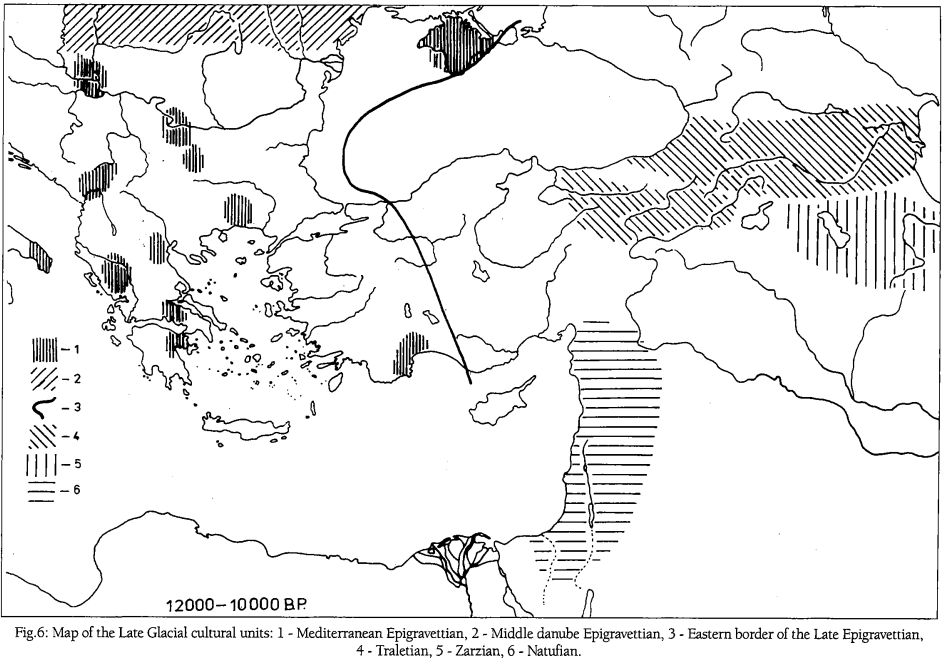
| DescriptionMap of Trialetian.png |
English: Map of distribution of Epi-Gravettian, Trialetian, Zarzian and Natufian cultures in the Balkans, Anatolia, Caucasus and the Middle East in 12000-10000 BP. Extracted under Creative Commons Attribution License (CC BY) from: J. K. Kozlowski, M. Kaczanowska. Gravettian/Epigravettian sequences in the Balkans and Anatolia, 2004, (pp.5-18). Mediterranean Archaeology and Archaeometry, Volume 4 - Issue 1. Link: http://www.maajournal.com/Issues2004a.php
Español: Mapa de distribución de las culturas epigravettiense, trialetiense, zarziense y natufiense en los Balcanes, Anatolia, Cáucaso y Oriente Medio en el intervalo 12000-10000 BP. Extraído bajo licencia Creative Commons Attribution License (CC BY) de: J. K. Kozlowski, M. Kaczanowska. Gravettian/Epigravettian sequences in the Balkans and Anatolia, 2004, (pp.5-18). Mediterranean Archaeology and Archaeometry, Volume 4 - Issue 1. Enlace: http://www.maajournal.com/Issues2004a.php |
| Date | |
| Source | J. K. Kozlowski, M. Kaczanowska. Gravettian/Epigravettian sequences in the Balkans and Anatolia, 2004, (pp.5-18). Mediterranean Archaeology and Archaeometry, Volume 4 - Issue 1. |
| Author | J. K. Kozlowski, M. Kaczanowska |
Licensing
This file is licensed under the Creative Commons Attribution-Share Alike 4.0 International license.
- You are free:
- to share – to copy, distribute and transmit the work
- to remix – to adapt the work
- Under the following conditions:
- attribution – You must give appropriate credit, provide a link to the license, and indicate if changes were made. You may do so in any reasonable manner, but not in any way that suggests the licensor endorses you or your use.
- share alike – If you remix, transform, or build upon the material, you must distribute your contributions under the same or compatible license as the original.
Captions
Map of distribution of Epi-Gravettian, Trialetian, Zarzian and Natufian cultures in the Balkans, Anatolia, Caucasus and the Middle East in the 12000-10000 BP interval.
Mapa de distribución de las culturas epigravettiense, trialetiense, zarziense y natufiense en los Balcanes, Anatolia, Cáucaso y Oriente Medio en el intervalo 12000-10000 BP.
Items portrayed in this file
depicts
2004
image/png
File history
Click on a date/time to view the file as it appeared at that time.
| Date/Time | Thumbnail | Dimensions | User | Comment | |
|---|---|---|---|---|---|
| current | 11:56, 10 June 2019 | | 943 × 663 (237 KB) | F. J. Blanco-Romero | User created page with UploadWizard |
File usage
The following pages on the English Wikipedia use this file (pages on other projects are not listed):
Global file usage
The following other wikis use this file:
- Usage on ca.wikipedia.org
- Usage on de.wikipedia.org
- Usage on fa.wikipedia.org
- Usage on ru.wikipedia.org
- Usage on tr.wikipedia.org
- Usage on uk.wikipedia.org
- Usage on www.wikidata.org
Metadata
This file contains additional information, probably added from the digital camera or scanner used to create or digitize it.
If the file has been modified from its original state, some details may not fully reflect the modified file.
| Software used |
|---|
Retrieved from "https://en.wikipedia.org/wiki/File:Map_of_Trialetian.png"