File:Mapcarpat2.png
From Wikipedia, the free encyclopedia
No higher resolution available.
Mapcarpat2.png (442 × 395 pixels, file size: 11 KB, MIME type: image/png)
| This is a file from the Wikimedia Commons. Information from its description page there is shown below. Commons is a freely licensed media file repository. You can help. |
Summary
| DescriptionMapcarpat2.png |
Dansk: Opdelingen af Karpaterne i sorte tal:
Floder i små blå bogstaver:
Lande (ISO 3166-1 alpha-2 codes), i røde kapitæler:
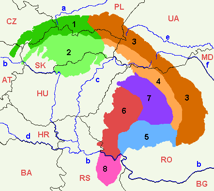
English: 1=Outer Western Carpathians, 2=Inner Western Carpathians, 3=Outer Eastern Carpathians, 4=Inner Eastern Carpathians, 5=Southern Carpathians or Transylvanian Alps, 6=Romanian Western Carpathians, 7=Transylvanian Plateau, 8=Serbian Carpathians. |
| Date | |
| Source | Own work |
| Author | :en:Markussep |
| Other versions | Mapcarpat.png |

|
Permission is granted to copy, distribute and/or modify this document under the terms of the GNU Free Documentation License, Version 1.2 or any later version published by the Free Software Foundation; with no Invariant Sections, no Front-Cover Texts, and no Back-Cover Texts. A copy of the license is included in the section entitled GNU Free Documentation License.http://www.gnu.org/copyleft/fdl.htmlGFDLGNU Free Documentation Licensetruetrue |
| This file is licensed under the Creative Commons Attribution-Share Alike 3.0 Unported license. | ||
| ||
| This licensing tag was added to this file as part of the GFDL licensing update.http://creativecommons.org/licenses/by-sa/3.0/CC BY-SA 3.0Creative Commons Attribution-Share Alike 3.0truetrue |
Captions
Add a one-line explanation of what this file represents
1=Зовнішні Західні Карпати, 2=Внутрішні Західні Карпати, 3=Зовнішні Східні Карпати, 4=Внутрішні Східні Карпати, 5=Південні Карпати або Трансільванські Альпи, 6=Румунські Західні Карпати, 7=Трансільванське плато, 8=Сербські Карпати.
Items portrayed in this file
depicts
12 July 2005
File history
Click on a date/time to view the file as it appeared at that time.
| Date/Time | Thumbnail | Dimensions | User | Comment | |
|---|---|---|---|---|---|
| current | 17:58, 7 April 2021 | | 442 × 395 (11 KB) | Keyacom | Changes: BH -> BA, fixed font for MD |
| 17:56, 7 April 2021 |  | 442 × 395 (11 KB) | Keyacom | Reverted to version as of 17:45, 6 January 2019 (UTC) cuz forgot to specify the actual changes | |
| 17:52, 7 April 2021 |  | 442 × 395 (11 KB) | Keyacom | changes: | |
| 17:45, 6 January 2019 |  | 442 × 395 (11 KB) | Julieta39 | Add MD | |
| 00:10, 1 February 2014 |  | 442 × 395 (12 KB) | Olahus | Small changes on Austria, Romania and Serbia. | |
| 08:23, 24 May 2007 |  | 442 × 395 (12 KB) | Zeman | {{Information |Description= |Source=self-made |Date= |Author= User:Zeman }} | |
| 11:52, 12 July 2005 |  | 442 × 395 (9 KB) | Markussep | ISO 3166-1 alpha-2 country codes | |
| 11:32, 12 July 2005 |  | 442 × 395 (9 KB) | Markussep | Annotated version of image file Mapcarpat.png |
File usage
The following pages on the English Wikipedia use this file (pages on other projects are not listed):
- Apuseni Mountains
- Banat Mountains
- Bistrița Mountains
- Bucegi Mountains
- Carpathian Mountains
- Central Beskidian Piedmont
- Central Europe
- Central Moravian Carpathians
- Central section of the Western Beskids
- Căliman-Harghita Mountains
- Devica
- Divisions of the Carpathians
- Eastern Beskids
- Eastern Carpathian Foothills
- Eastern section of the Western Beskids
- Fatra-Tatra Area
- Făgăraș Mountains group
- Giurgeu-Brașov Depression
- History of Maramureș
- Homolje Mountains
- Kučaj
- Low Beskids
- Lučenec-Košice Depression
- Meseș Mountains
- Moldavian-Muntenian Carpathians
- North Hungarian Mountains
- Northern Maramureș
- Outer Subcarpathia
- Parâng Mountains group
- Podhale-Magura Area
- Poiana Ruscă Mountains
- Polonynian Beskids
- Retezat-Godeanu Mountains group
- Romanian Carpathians
- Serbian Carpathians
- Slovak-Moravian Carpathians
- Slovak Central Mountains
- Slovak Ore Mountains
- South-Moravian Carpathians
- Southern Carpathians
- Transylvanian Plateau
- Ukrainian Carpathians
- Vihorlat-Gutin Area
- Western Beskidian Foothills
- Western Beskids
- Western Carpathians
- Western Romanian Carpathians
- Wooded Carpathians
- Șimleu Mountains
- Talk:Divisions of the Carpathians
- Talk:Northern Maramureș
- Template:Carpathian Mountains
- Template:Inner North-Eastern Carpathians
Global file usage
The following other wikis use this file:
- Usage on als.wikipedia.org
- Usage on ar.wikipedia.org
- Usage on arz.wikipedia.org
- Usage on ast.wikipedia.org
- Usage on ba.wikipedia.org
- Usage on be-tarask.wikipedia.org
- Usage on be.wikipedia.org
- Usage on bg.wikipedia.org
- Usage on bn.wikipedia.org
- Usage on bs.wikipedia.org
- Usage on ca.wikipedia.org
- Usage on cs.wikipedia.org
- Usage on da.wikipedia.org
- Usage on de.wikipedia.org
- Usage on de.wiktionary.org
- Usage on el.wikipedia.org
- Usage on eo.wikipedia.org
- Usage on es.wikipedia.org
- Usage on et.wikipedia.org
- Usage on eu.wikipedia.org
- Usage on frr.wikipedia.org
- Usage on fr.wikipedia.org
- Usage on ga.wikipedia.org
- Usage on he.wikipedia.org
View more global usage of this file.
Metadata
This file contains additional information, probably added from the digital camera or scanner used to create or digitize it.
If the file has been modified from its original state, some details may not fully reflect the modified file.
| Horizontal resolution | 28.35 dpc |
|---|---|
| Vertical resolution | 28.35 dpc |
Retrieved from "https://en.wikipedia.org/wiki/File:Mapcarpat2.png"