File:Mt_Taranaki_Drainage_System.jpg
From Wikipedia, the free encyclopedia
Mt_Taranaki_Drainage_System.jpg (540 × 439 pixels, file size: 81 KB, MIME type: image/jpeg)
| This is a file from the Wikimedia Commons. Information from its description page there is shown below. Commons is a freely licensed media file repository. You can help. |
Summary
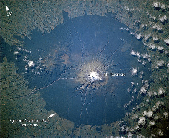
| DescriptionMt Taranaki Drainage System.jpg |
English: Radial drainage pattern Mount Taranaki.
Українська: Вулкан Таранакі (в центрі) та вулкан Поуакай (ліворуч). |
| Date | |
| Source | "Astronaut Photography of Earth - Display Record." <http://eol.jsc.nasa.gov/scripts/sseop/photo.pl?mission=STS110&roll=726&frame=6> (28 Apr. 2005). |
| Author | Image Science and Analysis Laboratory, NASA-Johnson Space Center. |
| Other versions |
|

| Object location | 39° 17′ 45.92″ S, 174° 03′ 50.04″ E | View this and other nearby images on: OpenStreetMap |
|---|
This image or video was catalogued by Goddard Space Flight Center of the United States National Aeronautics and Space Administration (NASA) under Photo ID: GL-2002-001576 and Alternate ID: STS110-726-6. This tag does not indicate the copyright status of the attached work. A normal copyright tag is still required. See Commons:Licensing. Other languages:
العربية ∙ беларуская (тарашкевіца) ∙ български ∙ català ∙ čeština ∙ dansk ∙ Deutsch ∙ English ∙ español ∙ فارسی ∙ français ∙ galego ∙ magyar ∙ հայերեն ∙ Bahasa Indonesia ∙ italiano ∙ 日本語 ∙ македонски ∙ മലയാളം ∙ Nederlands ∙ polski ∙ português ∙ русский ∙ sicilianu ∙ slovenščina ∙ Türkçe ∙ українська ∙ 简体中文 ∙ 繁體中文 ∙ +/− |
Licensing
| Public domainPublic domainfalsefalse |
| This file is in the public domain in the United States because it was solely created by NASA. NASA copyright policy states that "NASA material is not protected by copyright unless noted". (See Template:PD-USGov, NASA copyright policy page or JPL Image Use Policy.) | ||
 |
Warnings:
|
| Annotations InfoField | This image is annotated: View the annotations at Commons |
Pouakai Range with
Mt Pouakai (1400 m)
Kaitake Range
(684 m)
Captions
Items portrayed in this file
depicts
25 March 2005
39°17'45.924"S, 174°3'50.040"E
File history
Click on a date/time to view the file as it appeared at that time.
| Date/Time | Thumbnail | Dimensions | User | Comment | |
|---|---|---|---|---|---|
| current | 21:15, 17 April 2006 | | 540 × 439 (81 KB) | Zimbres | Radial drainage pattern Image Science and Analysis Laboratory, NASA-Johnson Space Center. 25 Mar. 2005. "Astronaut Photography of Earth - Display Record." <http://eol.jsc.nasa.gov/scripts/sseop/photo.pl?mission=STS110&roll=726&frame=6> (28 Apr. 2005). [ |
File usage
Global file usage
The following other wikis use this file:
- Usage on bn.wikipedia.org
- Usage on ceb.wikipedia.org
- Usage on de.wikipedia.org
- Usage on es.wikipedia.org
- Usage on gl.wikipedia.org
- Usage on hi.wikipedia.org
- Usage on ja.wikipedia.org
- Usage on mk.wikipedia.org
- Usage on ml.wikipedia.org
- Usage on nl.wikipedia.org
- Usage on nn.wikipedia.org
- Usage on pl.wikipedia.org
- Usage on pnb.wikipedia.org
- Usage on sl.wikipedia.org
- Usage on sv.wikipedia.org
- Usage on uk.wikipedia.org
- Usage on vi.wikipedia.org
- Usage on www.wikidata.org
Metadata
This file contains additional information, probably added from the digital camera or scanner used to create or digitize it.
If the file has been modified from its original state, some details may not fully reflect the modified file.
| _error | 0 |
|---|