File:National-atlas-delaware.png
From Wikipedia, the free encyclopedia
Size of this preview: 776 × 600 pixels. Other resolutions: 311 × 240 pixels | 621 × 480 pixels | 994 × 768 pixels | 1,280 × 989 pixels | 2,199 × 1,699 pixels.
Original file (2,199 × 1,699 pixels, file size: 848 KB, MIME type: image/png)
| This is a file from the Wikimedia Commons. Information from its description page there is shown below. Commons is a freely licensed media file repository. You can help. |
Transwiki approved by: w:en:User:Dmcdevit
This image was copied from wikipedia:en. The original description was:
| Public domainPublic domainfalsefalse |
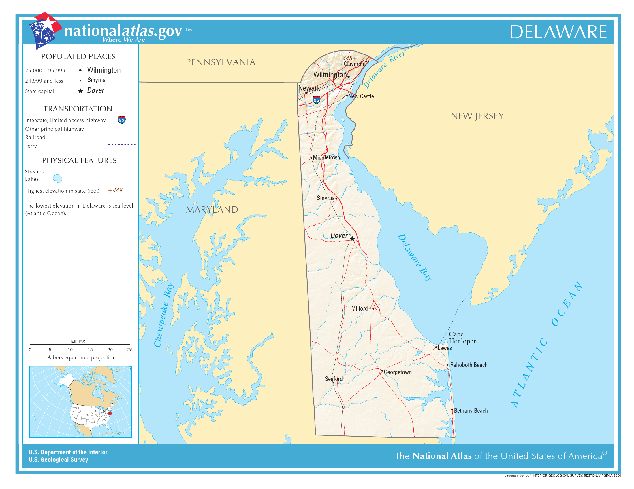
This map was obtained from an edition of the National Atlas of the United States. Like almost all works of the U.S. federal government, works from the National Atlas are in the public domain in the United States.
Online access: NationalAtlas.gov | 1970 print edition: Library of Congress, Perry-Castañeda Library čeština | Deutsch | English | français | Bahasa Indonesia | italiano | македонски | മലയാളം | sicilianu | 中文 | 中文(简体) | 中文(繁體) | +/− |
Original upload log
| date/time | username | resolution | size | edit summary |
|---|---|---|---|---|
| 10:42, 13 December 2004 | w:en:User:Berkut | 763×591 | 56 KB | reduced file size |
| 21:55, 4 November 2004 | w:en:User:Jengod | 763×591 | 154 KB | {{PD-USGov}} <a href="/wiki/Category:Delaware_maps" title="Category:Delaware maps">Category:Delaware maps</a> |
Image description page history
| link | date/time | username | edit summary |
|---|---|---|---|
| http://en.wikipedia.org/w/index.php?title=Image:National-atlas-delaware.png&redirect=no&oldid=16895891 | 07:11, 10 September 2007 | w:en:User:Dmcdevit | |
| http://en.wikipedia.org/w/index.php?title=Image:National-atlas-delaware.png&redirect=no&oldid=16895891 | 22:00, 30 November 2004 | w:en:User:Jengod | |
| http://en.wikipedia.org/w/index.php?title=Image:National-atlas-delaware.png&redirect=no&oldid=7995891 | 21:55, 4 November 2004 | w:en:User:Jengod | ({{PD-USGov}} <a href="/wiki/Category:Delaware_maps" title="Category:Delaware maps">Category:Delaware maps</a>) |
File history
Click on a date/time to view the file as it appeared at that time.
| Date/Time | Thumbnail | Dimensions | User | Comment | |
|---|---|---|---|---|---|
| current | 08:17, 16 September 2010 | | 2,199 × 1,699 (848 KB) | Redgolpe | Higher resolution |
| 16:05, 10 September 2007 |  | 763 × 591 (56 KB) | BetacommandBot | Transwiki approved by: w:en:User:Dmcdevit This image was copied from wikipedia:en. The original description was: {{PD-USGov-Atlas}} w:en:Category:Delaware maps === File history === {| class=wikitable ! date/time || username || resolution || siz |
File usage
The following pages on the English Wikipedia use this file (pages on other projects are not listed):
Global file usage
The following other wikis use this file:
- Usage on bs.wikipedia.org
- Usage on ca.wikipedia.org
- Usage on ceb.wikipedia.org
- Usage on eo.wikipedia.org
- Usage on es.wikipedia.org
- Usage on fa.wikipedia.org
- Usage on fi.wikipedia.org
- Usage on fr.wikipedia.org
- Usage on hr.wiktionary.org
- Usage on hu.wikipedia.org
- Usage on hy.wikipedia.org
- Usage on ja.wikipedia.org
- Usage on jv.wikipedia.org
- Usage on lt.wikipedia.org
- Usage on nl.wikipedia.org
- Usage on nl.wikinews.org
- Usage on pl.wikipedia.org
- Usage on ru.wikipedia.org
- Usage on simple.wikipedia.org
- Usage on uk.wikipedia.org
- Usage on zh.wikipedia.org
Metadata
This file contains additional information, probably added from the digital camera or scanner used to create or digitize it.
If the file has been modified from its original state, some details may not fully reflect the modified file.
| Horizontal resolution | 78.74 dpc |
|---|---|
| Vertical resolution | 78.74 dpc |
| File change date and time | 08:14, 16 September 2010 |
Retrieved from "https://en.wikipedia.org/wiki/File:National-atlas-delaware.png"