File:NezavisnaDrzavaHrvatska.png
From Wikipedia, the free encyclopedia
Size of this preview: 761 × 600 pixels. Other resolutions: 305 × 240 pixels | 609 × 480 pixels | 975 × 768 pixels | 1,280 × 1,009 pixels | 2,000 × 1,576 pixels.
Original file (2,000 × 1,576 pixels, file size: 643 KB, MIME type: image/png)
| This is a file from the Wikimedia Commons. Information from its description page there is shown below. Commons is a freely licensed media file repository. You can help. |
Summary
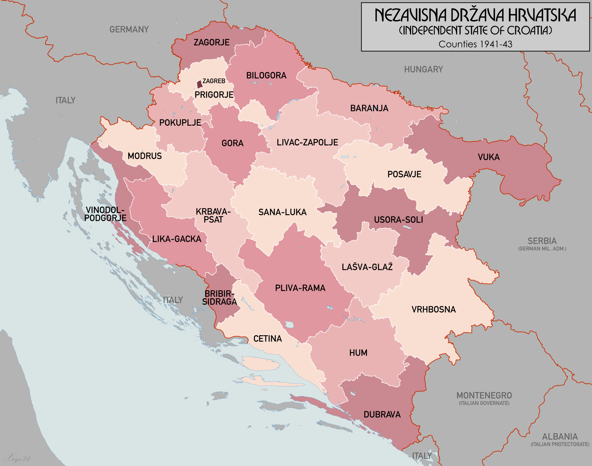
| DescriptionNezavisnaDrzavaHrvatska.png | Administrative Map of the Independent State of Croatia (Nezavisna Drzava Hrvatska) |
| Date | |
| Source | Own work |
| Author | XrysD |
Licensing
I, the copyright holder of this work, hereby publish it under the following licenses:

|
Permission is granted to copy, distribute and/or modify this document under the terms of the GNU Free Documentation License, Version 1.2 or any later version published by the Free Software Foundation; with no Invariant Sections, no Front-Cover Texts, and no Back-Cover Texts. A copy of the license is included in the section entitled GNU Free Documentation License.http://www.gnu.org/copyleft/fdl.htmlGFDLGNU Free Documentation Licensetruetrue |
| This file is licensed under the Creative Commons Attribution-Share Alike 3.0 Unported license. | ||
| ||
| This licensing tag was added to this file as part of the GFDL licensing update.http://creativecommons.org/licenses/by-sa/3.0/CC BY-SA 3.0Creative Commons Attribution-Share Alike 3.0truetrue |
You may select the license of your choice.
Captions
Add a one-line explanation of what this file represents
Items portrayed in this file
depicts
19 August 2008
File history
Click on a date/time to view the file as it appeared at that time.
| Date/Time | Thumbnail | Dimensions | User | Comment | |
|---|---|---|---|---|---|
| current | 20:21, 26 November 2014 | | 2,000 × 1,576 (643 KB) | XrysD | New font. |
| 15:32, 22 November 2014 |  | 2,000 × 1,576 (656 KB) | XrysD | Completely new version. Source data from Volkstumskarte von Jugoslawien 1:200k (Wilfried Krallert) Wien (1941). | |
| 22:56, 13 September 2011 |  | 1,780 × 1,580 (209 KB) | XrysD | Harmonised with other versions of the map. | |
| 22:33, 24 July 2011 |  | 890 × 749 (94 KB) | XrysD | Reverted to version as of 12:05, 11 October 2008 | |
| 10:10, 2 June 2011 |  | 890 × 749 (100 KB) | DIREKTOR | Simpler color scheme. | |
| 12:05, 11 October 2008 |  | 890 × 749 (94 KB) | XrysD | {{Information |Description=Counties of the Independent State of Croatia in 1941 |Source= |Date= |Author= |Permission= |other_versions= }} | |
| 09:18, 19 August 2008 |  | 660 × 592 (161 KB) | XrysD | {{Information |Description=Administrative Map of the Independent State of Croatia (Nezavisna Drzava Hrvatska) |Source=self-made |Date=19-08-2008 |Author= XrysD |Permission= |other_versions= }} |
File usage
The following pages on the English Wikipedia use this file (pages on other projects are not listed):
Global file usage
The following other wikis use this file:
- Usage on ast.wikipedia.org
- Usage on bs.wikipedia.org
- Usage on cs.wikipedia.org
- Usage on eo.wikipedia.org
- Usage on es.wikipedia.org
- Usage on fr.wikipedia.org
- Usage on hr.wikipedia.org
- Nezavisna Država Hrvatska
- Upravna podjela NDH
- Mraclin
- Velika župa Baranja
- Velika župa Hum
- Velika župa Dubrava
- Velika župa Prigorje
- Velika župa Vinodol-Podgorje
- Velika župa Vrhbosna
- Predložak:Velike župe u NDH
- Velika župa Zagorje
- Velike župe u NDH
- Velika župa Cetina
- Velika župa Bilogora
- Velika župa Vuka
- Velika župa Posavje
- Velika župa Livac-Zapolje
- Velika župa Gora
- Velika župa Gora-Prigorje
- Velika župa Pokupje
- Velika župa Modruš
- Velika župa Lika-Gacka
- Velika župa Bribir-Sidraga
- Velika župa Bribir
- Velika župa Sidraga-Ravni Kotari
- Velika župa Lašva-Glaž
- Velika župa Raša
- Velika župa Krbava-Psat
- Velika župa Pliva i Rama
- Velika župa Usora-Soli
- Velika župa Sana-Luka
- Velika župa Lašva-Pliva
- Kotari u NDH
- Suradnik:Imbehind/NDH
- Usage on it.wikipedia.org
- Usage on ja.wikipedia.org
- Usage on lt.wikipedia.org
- Usage on pt.wikipedia.org
View more global usage of this file.
Metadata
This file contains additional information, probably added from the digital camera or scanner used to create or digitize it.
If the file has been modified from its original state, some details may not fully reflect the modified file.
| Horizontal resolution | 8.63 dpc |
|---|---|
| Vertical resolution | 8.63 dpc |
Retrieved from "https://en.wikipedia.org/wiki/File:NezavisnaDrzavaHrvatska.png"