File:Population_density_of_Africa.jpg
From Wikipedia, the free encyclopedia
Original file (738 × 681 pixels, file size: 84 KB, MIME type: image/jpeg)
| This is a file from the Wikimedia Commons. Information from its description page there is shown below. Commons is a freely licensed media file repository. You can help. |
 | This image was uploaded in the JPEG format even though it consists of non-photographic data. This information could be stored more efficiently or accurately in the PNG or SVG format. If possible, please upload a PNG or SVG version of this image without compression artifacts, derived from a non-JPEG source (or with existing artifacts removed). After doing so, please tag the JPEG version with {{Superseded|NewImage.ext}} and remove this tag. This tag should not be applied to photographs or scans. If this image is a diagram or other image suitable for vectorisation, please tag this image with {{Convert to SVG}} instead of {{BadJPEG}}. If not suitable for vectorisation, use {{Convert to PNG}}. For more information, see {{BadJPEG}}. |  |
Summary
| DescriptionPopulation density of Africa.jpg |
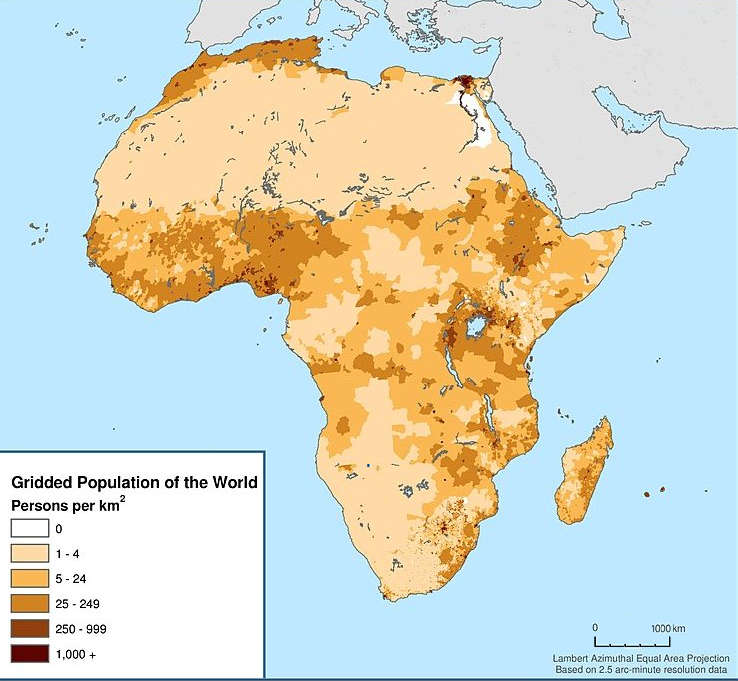
English: Map showing the population density of Africa. Title: Africa: Population Density, 2000 |
| Date | |
| Source | http://sedac.ciesin.columbia.edu/data/set/gpw-v3-population-density/maps |
| Author |
Center for International Earth Science Information Network - CIESIN - Columbia University, International Food Policy Research Institute - IFPRI, The World Bank, and Centro Internacional de Agricultura Tropical - CIAT. 2011. Global Rural-Urban Mapping Project, Version 1 (GRUMPv1): Urban Extents Grid (Africa). Palisades, NY: NASA Socioeconomic Data and Applications Center (SEDAC). http://sedac.ciesin.columbia.edu/data/set/grump-v1-urban-extents/maps. Accessed 12 October 2017. Source: Center for International Earth Science Information Network (CIESIN), Columbia University; and Centro Internacional de Agricultura Tropical (CIAT), Gridded Population of the World (GPW), Version 3. Palisades, NY: CIESIN, Columbia University. Available at: http://sedac.ciesin.columbia.edu/gpw." |
| Permission (Reusing this file) |
CC BY 3.0. See the previous versions of this file. |
Licensing
- You are free:
- to share – to copy, distribute and transmit the work
- to remix – to adapt the work
- Under the following conditions:
- attribution – You must give appropriate credit, provide a link to the license, and indicate if changes were made. You may do so in any reasonable manner, but not in any way that suggests the licensor endorses you or your use.
Captions
Items portrayed in this file
depicts
3 January 2000
File history
Click on a date/time to view the file as it appeared at that time.
| Date/Time | Thumbnail | Dimensions | User | Comment | |
|---|---|---|---|---|---|
| current | 15:02, 18 December 2017 | | 738 × 681 (84 KB) | Maproom | Removed credits, logos, etc. Lengthened scale. |
| 07:45, 12 December 2017 |  | 738 × 989 (131 KB) | ديفيد عادل وهبة خليل 2 | Removed border by cropping 7 % horizontally and 3 % vertically using CropTool with precise mode. | |
| 15:28, 12 October 2017 |  | 791 × 1,024 (129 KB) | Mrmisr | User created page with UploadWizard |
File usage
Global file usage
The following other wikis use this file:
- Usage on ha.wikipedia.org
- Usage on pnb.wikipedia.org
- Usage on ur.wikipedia.org
- Usage on vi.wikipedia.org
Metadata
This file contains additional information, probably added from the digital camera or scanner used to create or digitize it.
If the file has been modified from its original state, some details may not fully reflect the modified file.
| Width | 738 px |
|---|---|
| Height | 681 px |
| File change date and time | 15:00, 18 December 2017 |
| Software used | PaintShop Pro 18.00 |
| Image width | 738 px |
| Image height | 681 px |
| Horizontal resolution | 299 dpi |
| Vertical resolution | 299 dpi |