File:Potomacwatershedmap.png
From Wikipedia, the free encyclopedia
Size of this preview: 800 × 545 pixels. Other resolutions: 320 × 218 pixels | 640 × 436 pixels | 1,024 × 698 pixels | 1,467 × 1,000 pixels.
Original file (1,467 × 1,000 pixels, file size: 1.41 MB, MIME type: image/png)
| This is a file from the Wikimedia Commons. Information from its description page there is shown below. Commons is a freely licensed media file repository. You can help. |
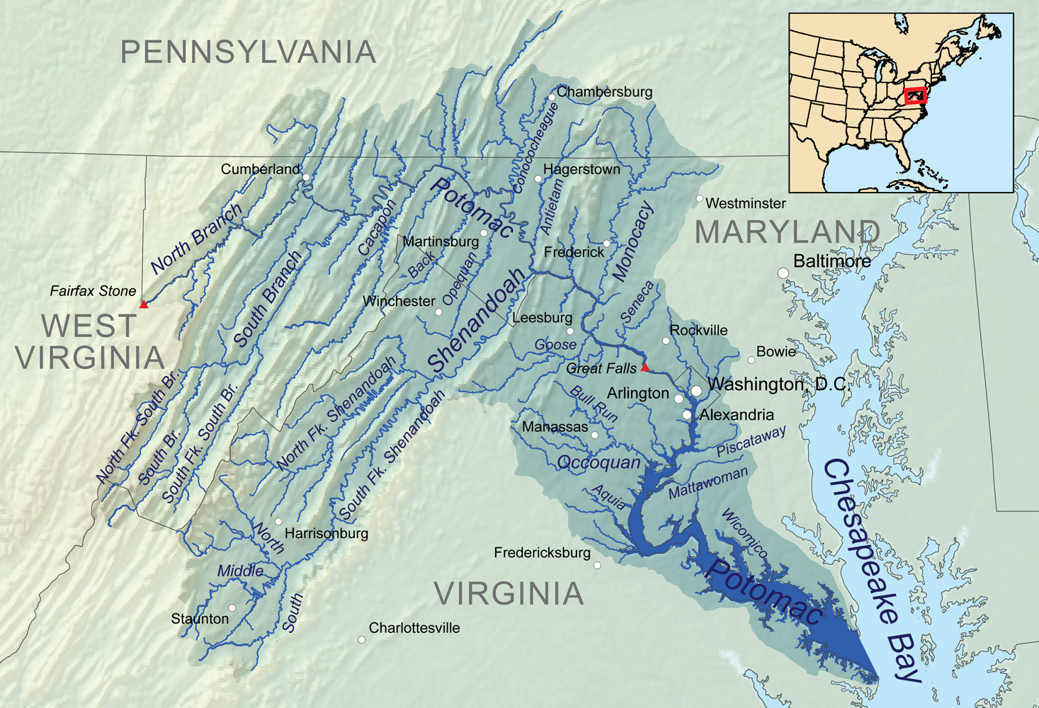
Summary
| DescriptionPotomacwatershedmap.png | Map showing the Potomac River drainage basin. |
| Date | |
| Source | Own work, Elevation data from SRTM, hydrologic data from the National Hydrography Dataset, urban areas from Vector Map, all other features from the National Atlas. |
| Author | Kmusser |
| Other versions | File:Potomac watershed.png |
Licensing
I, the copyright holder of this work, hereby publish it under the following license:
This file is licensed under the Creative Commons Attribution-Share Alike 3.0 Unported license.
- You are free:
- to share – to copy, distribute and transmit the work
- to remix – to adapt the work
- Under the following conditions:
- attribution – You must give appropriate credit, provide a link to the license, and indicate if changes were made. You may do so in any reasonable manner, but not in any way that suggests the licensor endorses you or your use.
- share alike – If you remix, transform, or build upon the material, you must distribute your contributions under the same or compatible license as the original.
Captions
Add a one-line explanation of what this file represents
Items portrayed in this file
depicts
3 January 2011
File history
Click on a date/time to view the file as it appeared at that time.
| Date/Time | Thumbnail | Dimensions | User | Comment | |
|---|---|---|---|---|---|
| current | 00:10, 4 January 2011 | | 1,467 × 1,000 (1.41 MB) | Kmusser | == Summary == {{Information |Description=Map showing the Potomac River drainage basin. |Source={{own}}, Elevation data from SRTM, hydrologic data from the [[:w:National Hydrography Dataset|Natio |
File usage
The following pages on the English Wikipedia use this file (pages on other projects are not listed):
Global file usage
The following other wikis use this file:
- Usage on ar.wikipedia.org
- Usage on ast.wikipedia.org
- Usage on azb.wikipedia.org
- Usage on br.wikipedia.org
- Usage on cs.wikipedia.org
- Usage on de.wikipedia.org
- Usage on eo.wikipedia.org
- Usage on es.wikipedia.org
- Maryland
- Baltimore
- Cumberland (Maryland)
- Bowie (Maryland)
- Westminster (Maryland)
- Frederick (Maryland)
- Hagerstown (Maryland)
- Río Potomac
- Charlottesville
- Condado de Arlington
- Alexandria (Virginia)
- Harrisonburg
- Winchester (Virginia)
- Fredericksburg (Virginia)
- Staunton (Virginia)
- Manassas (Virginia)
- Chambersburg
- Leesburg (Virginia)
- Great Falls (Virginia)
- Martinsburg (Virginia Occidental)
- Washington D. C.
- Río Shenandoah
- Usage on fi.wikipedia.org
- Usage on fr.wikipedia.org
- Usage on he.wikipedia.org
- Usage on hu.wikipedia.org
- Usage on io.wikipedia.org
- Usage on la.wikipedia.org
- Usage on lv.wikipedia.org
- Usage on mt.wikipedia.org
- Usage on pms.wikipedia.org
- Usage on pnb.wikipedia.org
- Usage on pt.wikipedia.org
- Usage on sh.wikipedia.org
- Usage on sr.wikipedia.org
- Usage on sv.wikipedia.org
- Usage on ta.wikipedia.org
- Usage on th.wikipedia.org
- Usage on uz.wikipedia.org
- Usage on www.wikidata.org
- Usage on xmf.wikipedia.org
View more global usage of this file.
Retrieved from "https://en.wikipedia.org/wiki/File:Potomacwatershedmap.png"