File:Priory_Road_Wells_Station.jpg
From Wikipedia, the free encyclopedia
No higher resolution available.
Priory_Road_Wells_Station.jpg (640 × 426 pixels, file size: 100 KB, MIME type: image/jpeg)
| This is a file from the Wikimedia Commons. Information from its description page there is shown below. Commons is a freely licensed media file repository. You can help. |
Summary
| DescriptionPriory Road Wells Station.jpg |
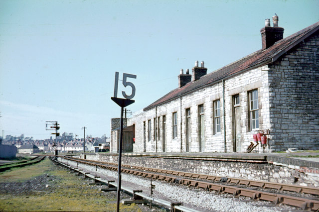
English: Priory Road Station, Wells Although England's smallest city, Wells had 2 railway stations less than a quarter of a mile apart. The Great Western line from Yatton to Witham had a station at Tucker Street. This station (which the GW trains passed through without stopping) was the end of the Somerset and Dorset branch from Glastonbury. At the far end of the station the route to Tucker Street bears right, to Glastonbury (only a siding when the picture was taken) left. |
| Date | |
| Source | From geograph.org.uk |
| Author | John Thorn |
| Permission (Reusing this file) |
Creative Commons Attribution Share-alike license 2.0 |
| Camera location | 51° 12′ 14.43″ N, 2° 39′ 09.56″ W | View this and other nearby images on: OpenStreetMap |
|---|
| Object location | 51° 12′ 18″ N, 2° 39′ 14″ W | View this and other nearby images on: OpenStreetMap |
|---|
Licensing

|
This image was taken from the Geograph project collection. See this photograph's page on the Geograph website for the photographer's contact details. The copyright on this image is owned by John Thorn and is licensed for reuse under the Creative Commons Attribution-ShareAlike 2.0 license.
|
This file is licensed under the Creative Commons Attribution-Share Alike 2.0 Generic license.
Attribution: John Thorn
- You are free:
- to share – to copy, distribute and transmit the work
- to remix – to adapt the work
- Under the following conditions:
- attribution – You must give appropriate credit, provide a link to the license, and indicate if changes were made. You may do so in any reasonable manner, but not in any way that suggests the licensor endorses you or your use.
- share alike – If you remix, transform, or build upon the material, you must distribute your contributions under the same or compatible license as the original.
Captions
Add a one-line explanation of what this file represents
Items portrayed in this file
depicts
some value
1963
51°12'14.429"N, 2°39'9.558"W
51°12'17.82"N, 2°39'14.04"W
image/jpeg
File history
Click on a date/time to view the file as it appeared at that time.
| Date/Time | Thumbnail | Dimensions | User | Comment | |
|---|---|---|---|---|---|
| current | 20:46, 23 November 2007 | | 640 × 426 (100 KB) | Lamberhurst | {{Information |Description=Priory Road Station, Wells |Source=http://www.geograph.org.uk/photo/316087 |Date=1963 |Author=John Thorn |Permission= |other_versions= }} {{cc-by-2.0}} |
File usage
The following pages on the English Wikipedia use this file (pages on other projects are not listed):
Global file usage
The following other wikis use this file:
- Usage on www.wikidata.org
Metadata
This file contains additional information, probably added from the digital camera or scanner used to create or digitize it.
If the file has been modified from its original state, some details may not fully reflect the modified file.
| Orientation | Normal |
|---|---|
| Horizontal resolution | 1,800 dpi |
| Vertical resolution | 1,800 dpi |
| Software used | Adobe Photoshop Elements 2.0 |
| File change date and time | 17:32, 31 January 2004 |
| Color space | Uncalibrated |
Retrieved from "https://en.wikipedia.org/wiki/File:Priory_Road_Wells_Station.jpg"