File:Relieve_karstico-Karst_topography.jpg
From Wikipedia, the free encyclopedia
Size of this preview: 800 × 189 pixels. Other resolutions: 320 × 76 pixels | 640 × 151 pixels | 2,103 × 497 pixels.
Original file (2,103 × 497 pixels, file size: 1.25 MB, MIME type: image/jpeg)
| This is a file from the Wikimedia Commons. Information from its description page there is shown below. Commons is a freely licensed media file repository. You can help. |
| DescriptionRelieve karstico-Karst topography.jpg |
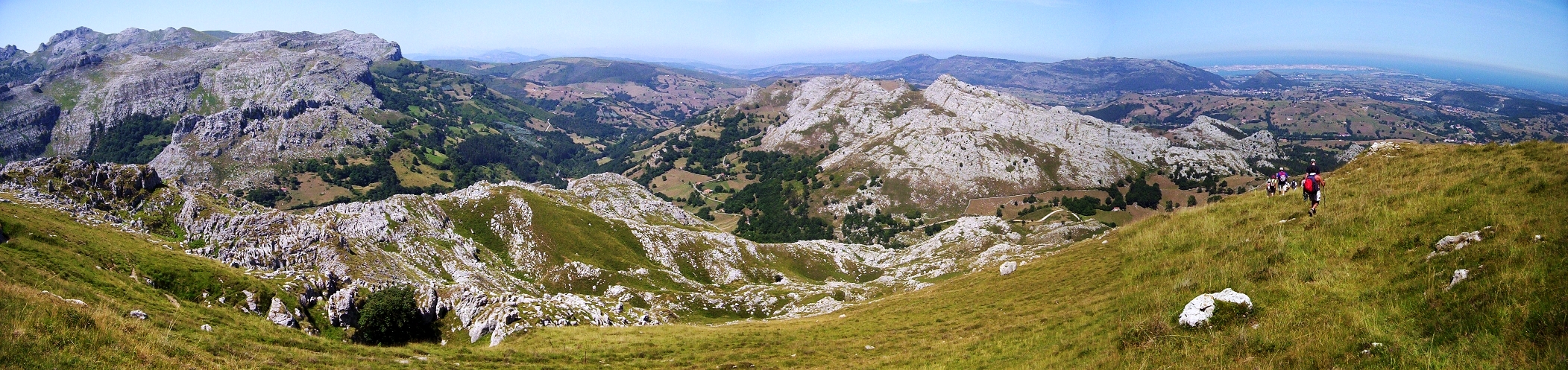
English: Karst topography in the Cantabrian Mountains. The port city of Santander in the distant right. Alto de Brenas (579 m.). Riotuerto. Cantabria. España
Español: Relieve kárstico en la Cordillera Cantábrica. Al fondo a la derecha se aprecia la ciudad portuaria de Santander. Alto de Brenas (579 m.). Riotuerto. Cantabria. Spain
Français : Relief karstique dans la Cordillère cantabrique. On aperçoit la ville portuaire de Santander au loin à droite. Alto de Brenas (579 m.). Riotuerto. Cantabrie. Espagne |
| Date | |
| Source | Own work |
| Author | Emilio Gómez Fernández. Post-Work: Jesús Gómez |
| Permission (Reusing this file) |
GFDL |
| Camera location | 43° 19′ 02.3″ N, 3° 41′ 29.7″ W | View this and other nearby images on: OpenStreetMap |
|---|

|
Permission is granted to copy, distribute and/or modify this document under the terms of the GNU Free Documentation License, Version 1.2 or any later version published by the Free Software Foundation; with no Invariant Sections, no Front-Cover Texts, and no Back-Cover Texts. A copy of the license is included in the section entitled GNU Free Documentation License.http://www.gnu.org/copyleft/fdl.htmlGFDLGNU Free Documentation Licensetruetrue |
| This file is licensed under the Creative Commons Attribution-Share Alike 3.0 Unported license. | ||
| ||
| This licensing tag was added to this file as part of the GFDL licensing update.http://creativecommons.org/licenses/by-sa/3.0/CC BY-SA 3.0Creative Commons Attribution-Share Alike 3.0truetrue |
Captions
Add a one-line explanation of what this file represents
Imagen panorámica de la zona baja del valle del Miera vista desde el Somo de Brenas.
Items portrayed in this file
depicts
August 2005
43°19'2.302"N, 3°41'29.699"W
File history
Click on a date/time to view the file as it appeared at that time.
| Date/Time | Thumbnail | Dimensions | User | Comment | |
|---|---|---|---|---|---|
| current | 17:20, 7 August 2005 | 2,103 × 497 (1.25 MB) | Corso |
File usage
The following pages on the English Wikipedia use this file (pages on other projects are not listed):
Global file usage
The following other wikis use this file:
- Usage on arz.wikipedia.org
- Usage on ast.wikipedia.org
- Usage on ca.wikipedia.org
- Usage on eo.wikipedia.org
- Usage on es.wikipedia.org
- Usage on eu.wikipedia.org
- Usage on fr.wikipedia.org
- Usage on gl.wikipedia.org
- Usage on ja.wikipedia.org
- Usage on kk.wikipedia.org
- Usage on mn.wikipedia.org
- Usage on nl.wikipedia.org
- Usage on pt.wikipedia.org
- Usage on ru.wikipedia.org
- Usage on sl.wikipedia.org
- Usage on zh.wikipedia.org
Metadata
This file contains additional information, probably added from the digital camera or scanner used to create or digitize it.
If the file has been modified from its original state, some details may not fully reflect the modified file.
| JPEG file comment | *Title English: {{{1}}} Karst topography |
|---|
