File:Sardinia_Language_Map.png
From Wikipedia, the free encyclopedia
Size of this preview: 465 × 599 pixels. Other resolutions: 186 × 240 pixels | 373 × 480 pixels | 596 × 768 pixels | 795 × 1,024 pixels | 1,590 × 2,048 pixels | 2,933 × 3,778 pixels.
Original file (2,933 × 3,778 pixels, file size: 2.28 MB, MIME type: image/png)
| This is a file from the Wikimedia Commons. Information from its description page there is shown below. Commons is a freely licensed media file repository. You can help. |

|
This linguistic map image could be re-created using vector graphics as an SVG file. This has several advantages; see Commons:Media for cleanup for more information. If an SVG form of this image is available, please upload it and afterwards replace this template with
{{vector version available|new image name}}.
It is recommended to name the SVG file “Sardinia Language Map.svg”—then the template Vector version available (or Vva) does not need the new image name parameter. |
Summary
| DescriptionSardinia Language Map.png |
Català: Mapa lingüístic de Sardenya (bilingüe)
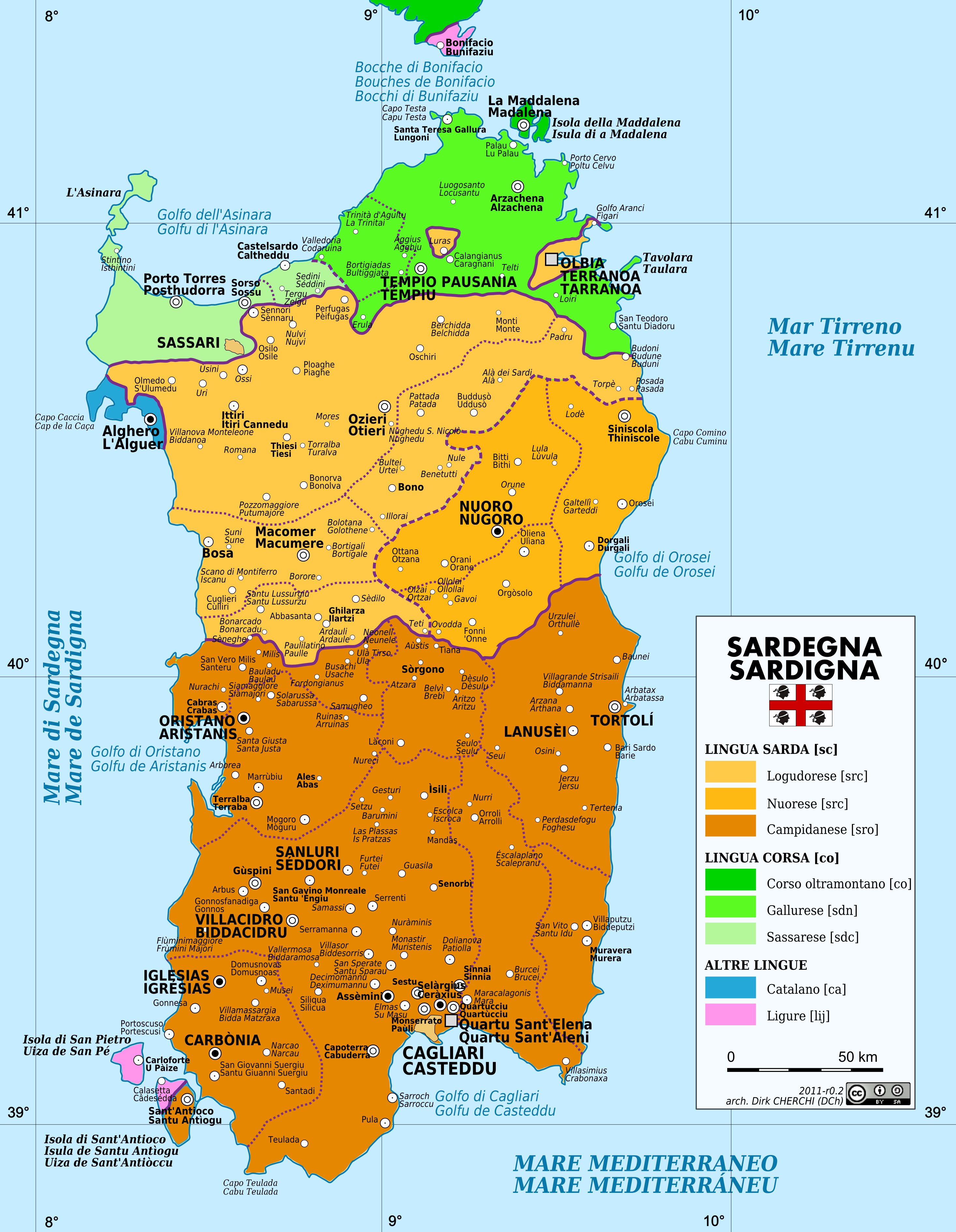
English: Linguistic map of Sardinia (bilingual). Languages, varieties and dialects in Sardinia. Yellow: the Sardinian languages, top left Logudorese (src), top right Nuorese (src) and below Campidanese (sro). Green: three Corsican languages, Corso oltramontano (co), Gallurese (sdn) en Sassarese (sdc). Blue: Catalan (ca), pink Ligurian (lij).
Esperanto: Lingva mapo de Sardio (dulingva)
Español: Mapa lingüístico de Cerdeña (bilingüe)
Italiano: Carta Linguistica della Sardegna (bilingue)
Nederlands: Talen, variëteiten en dialecten op Sardinië. Geel: de Sardijnse talen, linksboven Logudorees (src), rechtsboven Nuorees (src) en onder Campidanees (sro). Groen: drie Corsicaanse talen, Corso oltramontano (co), Gallurees (sdn) en Sassarees (sdc). Blauw: Catalaans (ca), roze Ligurisch (lij).
Sassaresu: Mappa Linguisthiga di la Sardhìgna (Bilingui)
Sardu: Mapa de sas limbas de sa Sardigna (bìlinguas) |
| Date | |
| Source | Own work |
| Author | Dch |
The factual accuracy of this map or the file name is disputed.
Reason: Please see the relevant discussion on the talk page. |  |
Licensing
I, the copyright holder of this work, hereby publish it under the following licenses:
This file is licensed under the Creative Commons Attribution-Share Alike 3.0 Unported license.
- You are free:
- to share – to copy, distribute and transmit the work
- to remix – to adapt the work
- Under the following conditions:
- attribution – You must give appropriate credit, provide a link to the license, and indicate if changes were made. You may do so in any reasonable manner, but not in any way that suggests the licensor endorses you or your use.
- share alike – If you remix, transform, or build upon the material, you must distribute your contributions under the same or compatible license as the original.

|
Permission is granted to copy, distribute and/or modify this document under the terms of the GNU Free Documentation License, Version 1.2 or any later version published by the Free Software Foundation; with no Invariant Sections, no Front-Cover Texts, and no Back-Cover Texts. A copy of the license is included in the section entitled GNU Free Documentation License.http://www.gnu.org/copyleft/fdl.htmlGFDLGNU Free Documentation Licensetruetrue |
You may select the license of your choice.
Captions
Bilingual linguistic map of Sardinia
Carta linguistica bilingue della Sardegna
Zweisprachige Sprachkarte Sardiniens
Items portrayed in this file
depicts
26 March 2009
image/png
File history
Click on a date/time to view the file as it appeared at that time.
| Date/Time | Thumbnail | Dimensions | User | Comment | |
|---|---|---|---|---|---|
| current | 20:42, 19 February 2012 | | 2,933 × 3,778 (2.28 MB) | Felisopus | updates&fix local names |
| 08:22, 30 July 2011 |  | 2,933 × 3,778 (2.29 MB) | Felisopus | fix local name | |
| 12:05, 17 June 2011 |  | 2,933 × 3,778 (2.16 MB) | Dch | Minor edits (02a) | |
| 12:51, 14 June 2011 |  | 2,933 × 3,778 (2.16 MB) | Dch | Updat official names | |
| 22:26, 12 April 2009 |  | 2,933 × 3,778 (2.04 MB) | Dch | Updates | |
| 17:39, 26 March 2009 |  | 2,933 × 3,778 (1.98 MB) | Dch | Reduced dimension | |
| 17:20, 26 March 2009 |  | 3,667 × 4,722 (2.54 MB) | Dch | {{Information |Description={{en|1=Administrative and road map of Sardinia (bilingual)}} {{it|1=Mappa amministrativa e stradale della Sardegna (bilingue)}} {{sc|1=Mapa de sas amministratziones e de sas carreras de sa Sardigna (biligua)}} |Source=Own work b |
File usage
The following pages on the English Wikipedia use this file (pages on other projects are not listed):
Global file usage
The following other wikis use this file:
- Usage on af.wikipedia.org
- Usage on an.wikipedia.org
- Usage on azb.wikipedia.org
- Usage on br.wikipedia.org
- Usage on ca.wikipedia.org
- Usage on co.wikipedia.org
- Usage on cs.wikipedia.org
- Usage on de.wikipedia.org
- Usage on de.wikivoyage.org
- Usage on en.wikibooks.org
- Usage on eo.wikipedia.org
- Usage on eo.wikivoyage.org
- Usage on es.wikipedia.org
- Usage on es.wiktionary.org
- Usage on eu.wikipedia.org
- Usage on fa.wikipedia.org
- Usage on frr.wikipedia.org
- Usage on fr.wikipedia.org
- Usage on gd.wikipedia.org
- Usage on gl.wikipedia.org
- Usage on hif.wikipedia.org
- Usage on hr.wikipedia.org
- Usage on hr.wiktionary.org
- Usage on hu.wikipedia.org
- Usage on hy.wikipedia.org
- Usage on ia.wikipedia.org
- Usage on id.wikipedia.org
- Usage on ilo.wikipedia.org
View more global usage of this file.
Metadata
This file contains additional information, probably added from the digital camera or scanner used to create or digitize it.
If the file has been modified from its original state, some details may not fully reflect the modified file.
| Horizontal resolution | 157.48 dpc |
|---|---|
| Vertical resolution | 157.48 dpc |
Retrieved from "https://en.wikipedia.org/wiki/File:Sardinia_Language_Map.png"