File:The_maximum_extent_of_the_Safavid_Empire_under_Shah_Abbas_I.png
From Wikipedia, the free encyclopedia
No higher resolution available.
The_maximum_extent_of_the_Safavid_Empire_under_Shah_Abbas_I.png (620 × 428 pixels, file size: 20 KB, MIME type: image/png)
| This is a file from the Wikimedia Commons. Information from its description page there is shown below. Commons is a freely licensed media file repository. You can help. |
Summary
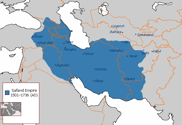
| DescriptionThe maximum extent of the Safavid Empire under Shah Abbas I.png |
English: The maximum extent of the Safavid Empire under Shah Abbas I. فارسی: حداکثر وسعت امپراتوری صفوی در زمان شاه عباس یکم. |
||
| Source | File:Safavid_Empire_1501_1722_AD.png | ||
| Author | Arab_Hafez, edited by HistoryofIran (me). | ||
| Other versions |
|

Licensing
| Public domainPublic domainfalsefalse |
| This map is ineligible for copyright and therefore in the public domain, because it consists entirely of information that is common property and contains no original authorship. For more information, see Commons:Threshold of originality § Maps.
English | Español | Galego | Română | slovenščina | العربية | 简体中文 | 繁體中文 | +/− |
Captions
Add a one-line explanation of what this file represents
امپراطوری صفوی در زمان شاه عباس یکم.
Items portrayed in this file
depicts
File history
Click on a date/time to view the file as it appeared at that time.
| Date/Time | Thumbnail | Dimensions | User | Comment | |
|---|---|---|---|---|---|
| current | 21:03, 1 January 2018 | | 620 × 428 (20 KB) | HistoryofIran | rv, take your concerns to the talk page |
| 21:54, 30 December 2017 |  | 620 × 428 (24 KB) | Qizilbash | Eastern Anatolia has never been under the control of Shah Abbas. After Shah Ismail this region has always been under Ottoman control. | |
| 04:56, 7 July 2015 |  | 620 × 428 (20 KB) | HistoryofIran | Removed disprutive edit from banned user. | |
| 02:03, 23 June 2015 |  | 620 × 428 (20 KB) | Artin Mehraban | the minor changes are examples of original research which is banned by wikipedia | |
| 04:09, 22 June 2015 |  | 620 × 428 (20 KB) | LouisAragon | they didn't rule such area under Abbas sigh. Stop being such a nuisance really. | |
| 23:12, 20 June 2015 |  | 620 × 428 (27 KB) | Artin Mehraban | changed the map size | |
| 23:03, 20 June 2015 |  | 582 × 401 (25 KB) | Artin Mehraban | It was well known Shah Abbas took daghestan | |
| 20:57, 20 June 2015 |  | 582 × 401 (24 KB) | Artin Mehraban | small edits | |
| 19:24, 20 June 2015 |  | 582 × 401 (23 KB) | Artin Mehraban | A few minor changes | |
| 04:00, 20 June 2015 |  | 585 × 414 (22 KB) | Artin Mehraban | Better text for cities |
File usage
The following pages on the English Wikipedia use this file (pages on other projects are not listed):
- Abbas II of Persia
- Azerbaijan Province (Safavid Iran)
- Baghdad Province (Safavid Empire)
- Erivan Province (Safavid Iran)
- Greater Iran
- Iranian Armenia (1502–1828)
- Marie Petit
- Safavid Astarabad
- Safavid Daghestan
- Safavid Diyarbakr
- Safavid Georgia
- Safavid Kandahar
- Safavid Karabakh
- Safavid Khuzestan
- Safavid Kurdistan
- Safavid Lorestan
- Safavid Shirvan
- Safavid Talish
- User:Falcaorib
- User:Kailanmapper/sandbox12
- User:Kailanmapper/sandbox4
- User:Kailanmapper/sandbox5
- User:LouisAragon/sandbox/Dagh
- User talk:EdJohnston/Archive 44
- Template:Safavid provinces
Global file usage
The following other wikis use this file:
- Usage on af.wikipedia.org
- Usage on azb.wikipedia.org
- Usage on az.wikipedia.org
- Usage on bn.wikipedia.org
- Usage on cs.wikipedia.org
- Usage on el.wikipedia.org
- Usage on en.wikibooks.org
- Usage on et.wikipedia.org
- Usage on eu.wikipedia.org
- Usage on fa.wikipedia.org
- استان اصفهان
- عراق
- استان کرمان
- استان خوزستان
- استان مازندران
- استان لرستان
- استان کردستان
- استان کهگیلویه و بویراحمد
- قندهار
- سیستان
- استان همدان
- مرو (شهر باستانی)
- آذربایجان
- مکران
- خراسان
- استان گیلان
- تاریخ گیلان در دوره صفویه
- ارمنستان ایران (۱۵۰۲–۱۸۲۸)
- ولایت داغستان
- ولایت قرهباغ
- چخور سعد
- ولایت گرجستان
- دیاربکر صفویه
- الگو:ولایتهای صفویه
- ولایت شیروان
- طایفه دمیرچی لو
- کاربر:Jdlrobson/test/ایران
- مری کلود پتی
- Usage on fi.wikipedia.org
- Usage on hy.wikipedia.org
- Usage on lrc.wikipedia.org
- Usage on lv.wikipedia.org
View more global usage of this file.
Metadata
This file contains additional information, probably added from the digital camera or scanner used to create or digitize it.
If the file has been modified from its original state, some details may not fully reflect the modified file.
| Horizontal resolution | 37.79 dpc |
|---|---|
| Vertical resolution | 37.79 dpc |