File:Thompson_Chicago_plat_1830.jpg
From Wikipedia, the free encyclopedia
Size of this preview: 366 × 599 pixels. Other resolutions: 146 × 240 pixels | 293 × 480 pixels | 959 × 1,570 pixels.
Original file (959 × 1,570 pixels, file size: 426 KB, MIME type: image/jpeg)
| This is a file from the Wikimedia Commons. Information from its description page there is shown below. Commons is a freely licensed media file repository. You can help. |
Summary
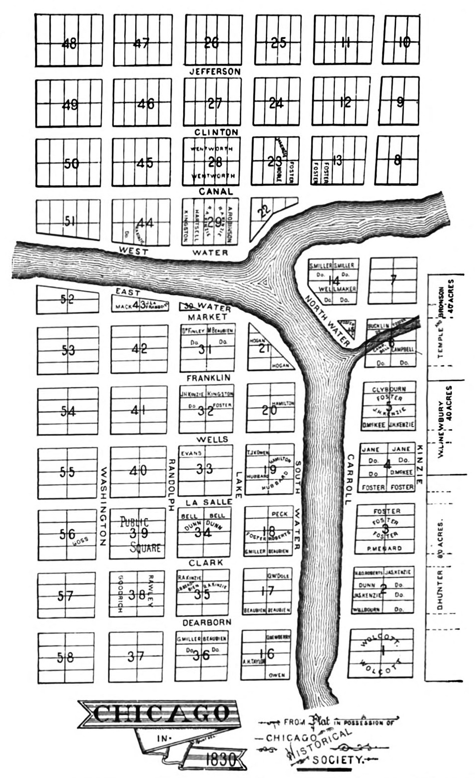
| DescriptionThompson Chicago plat 1830.jpg | The Illinois and Michigan Canal Commissioners hired James Thompson, a surveyor from Kaskaskia in downstate Randolph County, to create Chicago's first plat (or map showing proposed lots) in 1830. He laid out the town with straight streets uniformly 66 feet wide (the length of a surveyor's chain) with alleys 16 feet wide bisecting each block. |
| Date | |
| Source | Andreas, Alfred Theodore (1884). History of Chicago. Volume I, page 112.[1] |
| Author | James Thompson |
| Permission (Reusing this file) |
public domain due to date of publication |
| Other versions | [2] |
Licensing
| Public domainPublic domainfalsefalse |
This media file is in the public domain in the United States. This applies to U.S. works where the copyright has expired, often because its first publication occurred prior to January 1, 1929, and if not then due to lack of notice or renewal. See this page for further explanation.
|
 | |
 |
This image might not be in the public domain outside of the United States; this especially applies in the countries and areas that do not apply the rule of the shorter term for US works, such as Canada, Mainland China (not Hong Kong or Macao), Germany, Mexico, and Switzerland. The creator and year of publication are essential information and must be provided. See Wikipedia:Public domain and Wikipedia:Copyrights for more details.
|
Captions
Add a one-line explanation of what this file represents
Items portrayed in this file
depicts
1830
File history
Click on a date/time to view the file as it appeared at that time.
| Date/Time | Thumbnail | Dimensions | User | Comment | |
|---|---|---|---|---|---|
| current | 23:49, 18 July 2010 | | 959 × 1,570 (426 KB) | JeremyA | slight crop |
| 23:46, 18 July 2010 |  | 1,000 × 1,586 (274 KB) | JeremyA | {{Information |Description=Plat of Chicago made in 1830 by James Thompson |Source=Andreas, Alfred Theodore (1884). History of Chicago. Volume I, page 112.[http://books.google.com/books?id=wP0TAAAAYAAJ] |Date=1830 |Author=James Thompson |Permission=public |
File usage
The following pages on the English Wikipedia use this file (pages on other projects are not listed):
- 350 North Orleans
- Fulton House (Chicago)
- User:JeremyA/sandbox/Wolf Point
- User talk:TonyTheTiger/Archive 50
- Wikipedia:Featured picture candidates/September-2010
- Wikipedia:Featured picture candidates/Thompson Chicago plat 1830
- Wikipedia:Valued picture candidates/Map of Chicago 1830
- Wikipedia:Valued picture candidates/September-2010
- Wikipedia:WikiProject Chicago
- Wikipedia:WikiProject Chicago/Good articles
Metadata
This file contains additional information, probably added from the digital camera or scanner used to create or digitize it.
If the file has been modified from its original state, some details may not fully reflect the modified file.
| Orientation | Normal |
|---|---|
| Horizontal resolution | 300 dpi |
| Vertical resolution | 300 dpi |
| Software used | Adobe Photoshop CS4 Macintosh |
| File change date and time | 18:41, 18 July 2010 |
| Color space | Uncalibrated |
Retrieved from "https://en.wikipedia.org/wiki/File:Thompson_Chicago_plat_1830.jpg"