File:West_Pyramid_Tasmania_(Landsat).jpg
From Wikipedia, the free encyclopedia
No higher resolution available.
West_Pyramid_Tasmania_(Landsat).jpg (240 × 189 pixels, file size: 22 KB, MIME type: image/jpeg)
| This is a file from the Wikimedia Commons. Information from its description page there is shown below. Commons is a freely licensed media file repository. You can help. |
Summary
| DescriptionWest Pyramid Tasmania (Landsat).jpg |
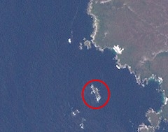
English: This image (Landsat 7) shows the West Pyramid island, off the south-west coast of the island Tasmania, Australia. Red circle added by User:Wurfzoll. |
| Date | |
| Source | http://oceancolor.gsfc.nasa.gov/cgi/landsat_extract.pl?path=91&row=90&x=564&y=368&n=0&t=321 |
| Author | NASA |
Licensing
| Public domainPublic domainfalsefalse |
| This file is in the public domain in the United States because it was solely created by NASA. NASA copyright policy states that "NASA material is not protected by copyright unless noted". (See Template:PD-USGov, NASA copyright policy page or JPL Image Use Policy.) | ||
 |
Warnings:
|
Captions
Add a one-line explanation of what this file represents
Items portrayed in this file
depicts
8 January 2000
File history
Click on a date/time to view the file as it appeared at that time.
| Date/Time | Thumbnail | Dimensions | User | Comment | |
|---|---|---|---|---|---|
| current | 09:57, 17 January 2014 | | 240 × 189 (22 KB) | Wurfzoll | User created page with UploadWizard |
File usage
The following pages on the English Wikipedia use this file (pages on other projects are not listed):
Global file usage
The following other wikis use this file:
- Usage on ceb.wikipedia.org
- Usage on www.wikidata.org
.jpg)