Object
| Status?
| Year/architect
| Town/section
| Address
| Coordinates
| Number?
| Image
|
"Hoeve Vogel-sanck" farm (nl)
|
|
|
Halen |
Betserbaan 72 |
50.95409°N 5.09268°E / 50.95409; 5.09268 (Relictid 21744 -) |
21744 Info |
|
farm (nl)
|
|
|
Halen |
Betserbaan 76 |
50.95296°N 5.09369°E / 50.95296; 5.09369 (Relictid 21745 -) |
21745 Info |
|
farm (nl)
|
|
|
Halen |
Ertsenrijkstraat 107 |
50.92907°N 5.12451°E / 50.92907; 5.12451 (Relictid 21748 -) |
21748 Info |
|
Closed farm 1852 (nl)
|
 Yes Yes |
|
Halen |
Ertsenrijkstraat 115 |
50.92547°N 5.12416°E / 50.92547; 5.12416 (Relictid 21749 -) |
21749 Info |
|
lock (nl)
|
|
|
Halen |
Firmin Jacobslaan |
50.94803°N 5.11688°E / 50.94803; 5.11688 (Relictid 21750 -) |
21750 Info |
|
broad House (nl)
|
|
|
Halen |
Generaal de Wittestraat 3 |
50.94830°N 5.11328°E / 50.94830; 5.11328 (Relictid 21752 -) |
21752 Info |
|
double House (nl)
|
|
|
Halen |
Generaal de Wittestraat 5 |
50.94838°N 5.11302°E / 50.94838; 5.11302 (Relictid 21753 -) |
21753 Info |
|
double House (nl)
|
Yes |
|
Halen |
Generaal de Wittestraat 10 |
50.94799°N 5.11262°E / 50.94799; 5.11262 (Relictid 21755 -) |
21755 Info |
|
double House (nl)
|
Yes |
|
Halen |
Generaal de Wittestraat 12 |
50.94799°N 5.11262°E / 50.94799; 5.11262 (Relictid 21755 -) |
21755 Info |
|
double House (nl)
|
|
|
Halen |
Generaal de Wittestraat 14 |
50.94799°N 5.11239°E / 50.94799; 5.11239 (Relictid 21756 -) |
21756 Info |
|
double House (nl)
|
|
|
Halen |
Generaal de Wittestraat 21 |
50.94831°N 5.11210°E / 50.94831; 5.11210 (Relictid 21757 -) |
21757 Info |
|
double House (nl)
|
|
|
Halen |
Koepoortstraat 5 |
50.94893°N 5.11479°E / 50.94893; 5.11479 (Relictid 21760 -) |
21760 Info |
|
Iron Mining farm (nl)
|
|
|
Halen |
Ijzerwinningstraat 2 |
50.94228°N 5.08834°E / 50.94228; 5.08834 (Relictid 21761 -) |
21761 Info |
|
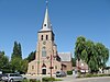
Parish St. Peter-in-Banden (nl)
|
Yes |
|
Halen |
Markt |
50.94862°N 5.11466°E / 50.94862; 5.11466 (Relictid 21764 -) |
21764 Info |

|
double House (nl)
|
Yes |
|
Halen |
Markt 9 |
50.94796°N 5.11357°E / 50.94796; 5.11357 (Relictid 21765 -) |
21765 Info |
|
only House (nl)
|
Yes |
|
Halen |
Markt 11 |
50.94757°N 5.11367°E / 50.94757; 5.11367 (Relictid 21766 -) |
21766 Info |
|
two homes (nl)
|
|
|
Halen |
Marktstraat 4 |
50.94718°N 5.11520°E / 50.94718; 5.11520 (Relictid 21771 -) |
21771 Info |
|
Farmer Burger House 1824 (nl)
|
Yes |
|
Halen |
Nederstraat 1 |
50.94812°N 5.11516°E / 50.94812; 5.11516 (Relictid 21772 -) |
21772 Info |
|
two homes (nl)
|
|
|
Halen |
Staatsbaan 106 |
50.95977°N 5.08641°E / 50.95977; 5.08641 (Relictid 21774 -) |
21774 Info |
|
two homes (nl)
|
|
|
Halen |
Staatsbaan 108 |
50.95977°N 5.08641°E / 50.95977; 5.08641 (Relictid 21774 -) |
21774 Info |
|
broad House (nl)
|
Yes |
|
Halen |
Zepbrugstraat 34 |
50.94039°N 5.10543°E / 50.94039; 5.10543 (Relictid 21778 -) |
21778 Info |
|
Jeneverdistillery, housing (nl)
|
|
|
Halen |
Zwarte Duivelsstraat 20 |
50.94860°N 5.11933°E / 50.94860; 5.11933 (Relictid 21779 -) |
21779 Info |
|
Watermill on the Gete, now home (nl)
|
|
|
Halen |
Zwarte Duivelsstraat 35 |
50.94809°N 5.11959°E / 50.94809; 5.11959 (Relictid 21781 -) |
21781 Info |

|
1912 Chapel St. Donatus (nl)
|
|
|
Halen |
Lindestraat |
50.92823°N 5.06356°E / 50.92823; 5.06356 (Relictid 21782 -) |
21782 Info |
|
Blekkom Castle, 1859 (nl)
|
|
|
Halen |
Lindestraat 124 |
50.92314°N 5.07567°E / 50.92314; 5.07567 (Relictid 21783 -) |
21783 Info |
|
St. Andrew Parish (nl)
|
|
|
Halen |
Loksbergenstraat |
50.93484°N 5.07054°E / 50.93484; 5.07054 (Relictid 21784 -) |
21784 Info |
|
Village house double house type (nl)
|
|
|
Halen |
Loksbergenstraat 43 |
50.93380°N 5.06818°E / 50.93380; 5.06818 (Relictid 21785 -) |
21785 Info |
|
Presbytery, classic double house (nl)
|
|
|
Halen |
Loksbergenstraat 25 |
50.93498°N 5.07096°E / 50.93498; 5.07096 (Relictid 21786 -) |
21786 Info |
|
village house (nl)
|
|
|
Halen |
Loksbergenstraat 54 |
50.93318°N 5.06846°E / 50.93318; 5.06846 (Relictid 21787 -) |
21787 Info |
|
Farmer Burger House, double house 1878 (nl)
|
|
|
Halen |
Loksbergenstraat 90 |
50.93215°N 5.06568°E / 50.93215; 5.06568 (Relictid 21789 -) |
21789 Info |
|
Semi-closed farm (nl)
|
|
|
Halen |
Oude Leuvensebaan 3 |
50.93408°N 5.05119°E / 50.93408; 5.05119 (Relictid 21790 -) |
21790 Info |
|
Vault Reynrode and chapel (nl)
|
|
|
Halen |
Oude Leuvensebaan 2 |
50.93437°N 5.05059°E / 50.93437; 5.05059 (Relictid 21791 -) |
21791 Info |
|
farm (nl)
|
|
|
Halen |
Oude Leuvensebaan 13 |
50.93481°N 5.05430°E / 50.93481; 5.05430 (Relictid 21792 -) |
21792 Info |
|
Rotemse mill (nl)
|
Yes |
|
Halen |
Gidsenstraat 24 |
50.92884°N 5.09219°E / 50.92884; 5.09219 (Relictid 21794 -) |
21794 Info |

|
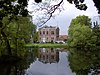
Abbey Mariendal, also called "Abbey Rothem" (nl)
|
Yes |
|
Halen |
Rotemstraat 4 |
50.92845°N 5.09759°E / 50.92845; 5.09759 (Relictid 21795 -) |
21795 Info |
|
Farm standalone components (nl)
|
Yes |
|
Halen |
Rotemstraat 14 |
50.92721°N 5.09265°E / 50.92721; 5.09265 (Relictid 21797 -) |
21797 Info |
|
St Pancras Parish Church (nl)
|
|
|
Halen |
Kerkstraat |
50.96081°N 5.09049°E / 50.96081; 5.09049 (Relictid 21798 -) |
21798 Info |

|
Presbytery classical double house (nl)
|
|
|
Halen |
Kerkstraat 10 |
50.96055°N 5.09095°E / 50.96055; 5.09095 (Relictid 21799 -) |
21799 Info |
|
Zelker watermill (nl)
|
|
|
Halen |
Zelemstraat 7 |
50.96113°N 5.09015°E / 50.96113; 5.09015 (Relictid 21801 -) |
21801 Info |
|
Parish Church Saint-Lambert (nl)
|
Yes |
|
Halen |
Dorpsstraat 36 |
50.97968°N 5.10423°E / 50.97968; 5.10423 (Relictid 21803 -) |
21803 Info |
|
"Hoeve Eksterhoek" semi closed farm (nl)
|
|
|
Halen |
Eksterhoekstraat 1 |
50.97113°N 5.08687°E / 50.97113; 5.08687 (Relictid 21804 -) |
21804 Info |
|
"Geesthuis" double-wide house (nl)
|
Yes |
|
Halen |
Gennepstraat 22 |
50.98375°N 5.08426°E / 50.98375; 5.08426 (Relictid 21805 -) |
21805 Info |
|
Men's double house Property Type (nl)
|
|
|
Halen |
Kolenbergstraat 26 |
50.97616°N 5.09817°E / 50.97616; 5.09817 (Relictid 21809 -) |
21809 Info |
|
Loboshoeve castle farm (nl)
|
|
|
Halen |
Lobosstraat 2 |
50.98333°N 5.10800°E / 50.98333; 5.10800 (Relictid 21810 -) |
21810 Info |
|
farm (nl)
|
|
|
Halen |
Schomstraat |
50.97249°N 5.09499°E / 50.97249; 5.09499 (Relictid 21811 -) |
21811 Info |
|
Carthusian Monastery St. Jansdal (nl)
|
Yes |
|
Halen |
Sint-Jansbergstraat 7-8-9 |
50.96961°N 5.09143°E / 50.96961; 5.09143 (Relictid 21812 -) |
21812 Info |

|
Our Lady Chapel (nl)
|
|
|
Halen |
Steenbergstraat |
50.97465°N 5.11085°E / 50.97465; 5.11085 (Relictid 21813 -) |
21813 Info |
|
"Hoeve Oude Pastorij" U-shaped farm (nl)
|
|
|
Halen |
Steenbergstraat 20 |
50.97276°N 5.09896°E / 50.97276; 5.09896 (Relictid 21814 -) |
21814 Info |
|
"Hoeve Oude Pastorij" U-shaped farm (nl)
|
|
|
Halen |
Steenbergstraat 22 |
50.97276°N 5.09896°E / 50.97276; 5.09896 (Relictid 21814 -) |
21814 Info |
|
rectory (nl)
|
|
|
Halen |
Dorpsstraat 34 |
50.97987°N 5.10325°E / 50.97987; 5.10325 (Relictid 88629 -) |
88629 Info |

|
school section (nl)
|
|
|
Halen |
Dorpsstraat 39 |
50.97905°N 5.10436°E / 50.97905; 5.10436 (Relictid 88630 -) |
88630 Info |
|
Pan Factory "De Panoven" (nl)
|
Yes |
|
Halen |
Panovenstraat 45 |
50.93124°N 5.07110°E / 50.93124; 5.07110 (Relictid 200349 -) |
200349 Info |
|
Belgian military cemetery (nl)
|
Yes |
|
Halen |
Liniestraat |
50.93702°N 5.09905°E / 50.93702; 5.09905 (Relictid 200660 -) |
200660 Info |
 |
_(21764)_18-08-2019.jpg)


