
Sajó
River in Slovakia and Hungary / From Wikipedia, the free encyclopedia
Dear Wikiwand AI, let's keep it short by simply answering these key questions:
Can you list the top facts and stats about Sajó?
Summarize this article for a 10 year old
SHOW ALL QUESTIONS
The Sajó (Hungarian pronunciation: [ˈʃɒjoː] SHOH-yoe, Hungarian) or Slaná (Slovak) is a river in Slovakia and Hungary.
This article needs additional citations for verification. (February 2018) |
Quick Facts Sajó Slaná, Location ...
| Sajó Slaná | |
|---|---|
 The river between Sajóvámos and Szirmabesenyő | |
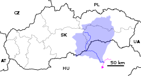  Current and watershed of the Sajó River in Slovakia and Hungary | |
| Location | |
| Countries | Slovakia and Hungary |
| Physical characteristics | |
| Source | |
| • location | Stolica Mountains |
| • coordinates | 48°46′34.4388″N 20°12′34.6464″E |
| • elevation | 1,229 m (4,032 ft) |
| Mouth | |
• location | Tisza |
• coordinates | 47.9437°N 21.1142°E / 47.9437; 21.1142 |
• elevation | 91 m (299 ft) |
| Length | 229.4 km (142.5 mi) |
| Basin size | 12,708.3 km2 (4,906.7 sq mi)[1] to 12,869.6 km2 (4,969.0 sq mi)[2] |
| Discharge | |
| • location | Tiszaújváros, Hungary (near mouth) |
| • average | 65.6 m3/s (2,320 cu ft/s) to 78.623 m3/s (2,776.5 cu ft/s)[2] |
| Discharge | |
| • location | Miskolc (53.205 rkm; Basin size: 6,245.8 km2 (2,411.5 sq mi) |
| • average | 35.087 m3/s (1,239.1 cu ft/s)[2] |
| Discharge | |
| • location | Kazincbarcika (88.4 rkm; Basin size: 4,361 km2 (1,684 sq mi) |
| • average | 24.473 m3/s (864.3 cu ft/s)[2] |
| Discharge | |
| • location | Bánréve, Sajópüspöki (123.6 rkm; Basin size: 3,204.7 km2 (1,237.3 sq mi) |
| • average | 20.55 m3/s (726 cu ft/s)[2] |
| Discharge | |
| • location | Rožňava (Rozsnyó, 177.5 rkm; Basin size: 301.53 km2 (116.42 sq mi) |
| • average | 3.264 m3/s (115.3 cu ft/s)[2] |
| Basin features | |
| Progression | Tisza→ Danube→ Black Sea |
| Tributaries | |
| • left | Takta, Hernád, Bódva, Szuha |
| • right | Szinva, Bán-patak, Hangony, Rimava, Turiec, Muráň, Štítnik |
Close
Its length is 229 km, of which 110 km is in Slovakia. Its source is in the Stolica Mountains range of the Slovak Ore Mountains. It flows through the Slovak town Rožňava and the Hungarian city Miskolc. In Hungary Sajó flows through the county of Borsod-Abaúj-Zemplén. It flows into the River Tisza near Tiszaújváros. Its main tributaries are the Bodva and the Hornád. It is also known for the Battle of the Sajó River from 11 April 1241 between the Mongol Empire and the Kingdom of Hungary.