User:Northamerica1000/Portals of the world
From Wikipedia, the free encyclopedia
The time allocated for running scripts has expired. The time allocated for running scripts has expired.
| This is a Wikipedia user page. This is not an encyclopedia article or the talk page for an encyclopedia article. If you find this page on any site other than Wikipedia, you are viewing a mirror site. Be aware that the page may be outdated and that the user in whose space this page is located may have no personal affiliation with any site other than Wikipedia. The original page is located at https://en.wikipedia.org/wiki/User:Northamerica1000/Portals_of_the_world. |
List of selected articles |
|---|
List of selected articles |
|---|
List of selected articles |
|---|
List of selected articles |
|---|
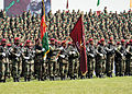 Image 1Soldiers of the Afghan National Army in 2010, including the ANA Commando Battalion standing in the front.
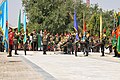 Image 2President Hamid Karzai observing the honor guard of the Afghan armed forces during the 2011 Afghan Independence Day. (from Culture of Afghanistan)
 Image 3Former Pakistani President Pervez Musharraf sent more troops against the United Front of Ahmad Shah Massoud than the Afghan Taliban. (from History of Afghanistan)
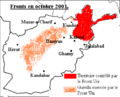 Image 4Map of the situation in Afghanistan in August 2001 until October 2001 (from History of Afghanistan)
 Image 5King Yaqub Khan with Britain's Sir Pierre Louis Napoleon Cavagnari, 26 May 1879, on the occasion of the signing of the Treaty of Gandamak (from History of Afghanistan)
 Image 6Much of the area corresponding to modern-day Afghanistan was subordinated to the Achaemenid Empire (from History of Afghanistan)
 Image 7The Mahajanapadas, including the Gandhara and Kambojas kingdoms and Achaemenid Empire in West, around c. 500 BCE (from History of Afghanistan)
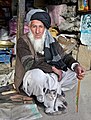
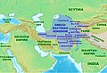 Image 10Approximate maximum extent of the Greco-Bactrian kingdom circa 180 BCE, including the regions of Tapuria and Traxiane to the West, Sogdiana and Ferghana to the north, Bactria and Arachosia to the south. (from History of Afghanistan)
 Image 11Some of the popular Afghan dishes, from left to right: 1. Lamb grilled kebab (seekh kabab); 2. Palao and salad; 3. Tandoori chicken; and 4. Mantu (dumplings). The Afghan cuisine includes a blend of Central Asian, Eastern Asian, South Asian and the Middle Eastern cuisines. Nearly all Afghan dishes are non-spicy. (from Culture of Afghanistan)
 Image 12Timurid Empire at its greatest extent in 1405 (from History of Afghanistan)
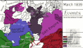 Image 14Map of Afghanistan 1839–1863, showing the First Anglo-Afghan war, and unification of Afghanistan by Dost Mohammad Khan (from History of Afghanistan)
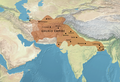 Image 15Map of Ghurid territory, before the assassination of Muhammad of Ghor. In the west, Ghurid territory extended to Nishapur and Merv, while Ghurid troops reached as far as Gorgan on the shores of the Caspian Sea. Eastward, the Ghurids invaded as far as Bengal. (from History of Afghanistan)
 Image 16Women painting at the Center for Contemporary Arts Afghanistan (CCAA) in Kabul. (from Culture of Afghanistan)
 Image 17The Bimaran casket, representing the Buddha surrounded by Brahma (left) and Śakra (right) was found inside a stupa with coins of Azes inside. British Museum. (from History of Afghanistan)
 Image 20The day after the Marxist revolution on April 28, 1978 (from History of Afghanistan)
 Image 21Afghan President Hamid Karzai speaking before U.S. Congress in June 2004 (from History of Afghanistan)
 Image 22Alexander's troops beg to return home from India in plate 3 of 11 by Antonio Tempesta of Florence, 1608. (from History of Afghanistan)
 Image 23Elements of Afghan culture including: tabla and harmonium musical instruments, an Afghan carpet, teapot, and sheer pira dessert (from Culture of Afghanistan)
 Image 24Tents of Afghan nomads in the northern Badghis province of Afghanistan. Early peasant farming villages came into existence in Afghanistan about 7,000 years ago. (from History of Afghanistan)
 Image 25Songbirds in cages at a farm in Nangarhar Province, used for the pleasure of the site's farmers (from Culture of Afghanistan)
 Image 26Map of the Hotak Empire during the Reign of Mirwais Hotak, 1715. (from History of Afghanistan)
 Image 27Map of the region during the 7th century (from History of Afghanistan)
 Image 28Kabul during civil war in 1993. (from History of Afghanistan)
 Image 29Outside the Presidential Palace in Kabul, a day after the Marxist revolution on April 28, 1978. (from History of Afghanistan)
 Image 30Map of the situation in Afghanistan in late 1996; Massoud (red), Dostum (green) and Taliban (yellow) territories. (from History of Afghanistan)
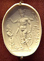 Image 31Vishnu Nicolo Seal representing Vishnu with a worshipper (probably Mihirakula), 4th–6th century CE. The inscription in cursive Bactrian reads: "Mihira, Vishnu and Shiva". British Museum. (from History of Afghanistan)
 Image 32Ethno-linguistic map of Afghanistan 1997 (from History of Afghanistan)
 Image 33Ethnolinguistic groups in Afghanistan in 1982 (from History of Afghanistan)
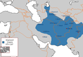 Image 34Ghaznavid Empire at its greatest extent in 1030 CE (from History of Afghanistan)
 Image 35Hotaki Empire, 1728 (from History of Afghanistan)
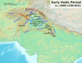

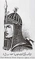
 Image 39Typical Afghan food table (from Culture of Afghanistan)
 Image 40Arachosia, Aria and Bactria were the ancient satraps of the Achaemenid Empire that made up most of what is now Afghanistan during 500 BCE. (from History of Afghanistan)
 Image 41Present-day location of Afghanistan in Asia (from History of Afghanistan)
 Image 42Mongol invasions and conquests seriously depopulated large areas of Afghanistan (from History of Afghanistan)
 Image 43Map of Afghanistan (Emirate) and surrounding nations, dated 1860. (from History of Afghanistan)
 Image 45A miniature from Padshahnama depicting the surrender of the Shia Safavid garrison of Kandahar in 1638 to the Mughal army of Shah Jahan commanded by Kilij Khan. (from History of Afghanistan)
 Image 46Kushan territories (full line) and maximum extent of Kushan dominions under Kanishka (dotted line), according to the Rabatak inscription. (from History of Afghanistan)
 Image 48Mohammad Zahir Shah in 1963
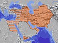 Image 49The Sasanian Empire at its greatest extent c. 620, under Khosrow II (from History of Afghanistan)
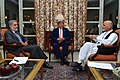 Image 51From left to right: Abdullah Abdullah, John Kerry and Ashraf Ghani during the 2014 Afghan presidential election (from History of Afghanistan)
 Image 52An Afghan boy with a kite (from Culture of Afghanistan)
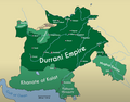 Image 53The Afghan Durrani Empire at its height in 1761. (from History of Afghanistan)
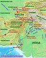 Image 54Alexander Empire in South Asia (from History of Afghanistan)


.PNG)


.jpg)

.jpg)


.jpg)
.png)


.PNG)

.png)
.jpg)

_Colonel_(COL)_Kevin_McDonnell_(background_center),_Commander,_1ST_Battalion,_3rd_Special_Forces_Group_(SFG)_and_Afghanistan_National_Army_(ANA)_COL_Nahji_Bulla_(to_COL_McDonnells_right)_were_special_guest_at_a_lunch.jpg)


.png)


{{Afghanistan topics}}
{{Anglo-Afghan War}}
{{Cinema of Afghanistan}}
{{Afghan clothing}}
{{Dams and reservoirs in Afghanistan}}
{{DRA topics}}
{{Afghan diaspora}}
{{Durrani dynasty}}
{{Ethnic groups in Afghanistan}}
{{International schools in Afghanistan}}
{{Languages of Afghanistan}}
{{Mosques in Afghanistan}}
{{National sports teams of Afghanistan}}
{{AfghanPrisons}}
{{Provinces of Afghanistan}}
{{Afghan security forces}}
{{Television stations in Afghanistan}}
{{Afghan universities}}
{{Years in Afghanistan}}
{{Soviet–Afghan War}}
{{Afghanistan War}}
{{Military operations in the war in Afghanistan}}
{{US War on Terror}}
{{Economic Cooperation Organization}}
{{South Asian Association for Regional Cooperation}}

.jpg)

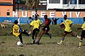 Image 2Football in Burundi (from Culture of Burundi)
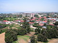 Image 3Central Bujumbura, capital of Burundi (from Culture of Burundi)
 Image 4People fleeing during 1993 Burundian genocide (from History of Burundi)
 Image 5Burundian Drummers (from Culture of Burundi)
.svg)


- For more images of Burundi, see the Wiki Loves Africa in Burundi category at Wikimedia Commons.

 Image 1Kribi Beach (from Tourism in Cameroon)
 Image 2Cameroonian fashion is varied and often mixes modern and traditional elements. Note the wearing of sun glasses, Monk shoes, sandals, and a Smartwatch. (from Culture of Cameroon)
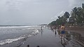 Image 3Limbe Beach with people engaging in various activities (from Tourism in Cameroon)
 Image 4A musician plays traditional African music during the closing ceremony of French RECAMP-concept (reinforcement of African peacekeeping capacities) in Douala, November 23, 2006 (from Culture of Cameroon)
 Image 5National Museum, Yaounde (from Tourism in Cameroon)
 Image 6Reunification Monument, Yaounde (from Tourism in Cameroon)
 Image 7Gorilla at Mefou primate sanctuary (from Tourism in Cameroon)
 Image 8Giraffes in Waza National Park (from Tourism in Cameroon)
 Image 9Hippopotamus at the Benoue National Park (from Tourism in Cameroon)
 Image 10Chimpanzee at Mefou primate sanctuary (from Tourism in Cameroon)


The Central African Republic sent three competitors to the 2008 Summer Olympics in Beijing, China. Béranger Bosse and Mireille Derebona represented the nation in track events, while Bruno Bongongo participated on the Central African Republic's behalf in boxing. Of those athletes, none progressed past the first rounds of their events. The appearance of the Central African delegation at the Beijing Olympics marked its eighth appearance since the nation's debut at the 1968 Summer Olympics in Mexico City and its seventh consecutive appearance at the Summer Olympics. At the ceremonies, Derebona was the nation's flag bearer. (Full article...)
 Image 1First Central African President David Dacko in 1962 (from History of the Central African Republic)
 Image 2Séléka advances in C.A.R. (December 2012–March 2013) (from History of the Central African Republic)
 Image 3Fufu (pictured right) is a staple food of West and Central Africa. It is a thick paste made by boiling starchy root vegetables in water and pounding the mixture with a mortar and pestle. Peanut soup is pictured at left (from Cuisine of the Central African Republic)
 Image 4Faustin Touadera succeeded interim head Catherine Samba-Panza to become president following the 2015–16 elections (from History of the Central African Republic)
 Image 6Rebel in northern Central African Republic in 2007. (from History of the Central African Republic)
 Image 9A food aid convoy in the Central African Republic in 2007 (from Cuisine of the Central African Republic)
 Image 10Location of the Central African Republic (from Cuisine of the Central African Republic)
 Image 11A soldier with France's 11th Marine Artillery Regiment during military exercises in the Central African Republic in 1992 (from History of the Central African Republic)


.jpg)
.jpg)

 Image 2GDP per capita development of Chad, since 1950 (from Chad)
 Image 3A Chadian tailor sells traditional dresses. (from Chad)
 Image 4A proportional representation of Chad exports, 2019 (from Chad)
 Image 5Chad is divided into three distinct zones, the Sudanian Savanna in the south, the Sahara Desert in the north, and the Sahelian belt in the center. (from Chad)
 Image 7The Aozou Strip (dark green), claimed and occupied by Libya between 1976 and 1987, and territories held by Libyan-backed GUNT-forces (light green) (from History of Chad)
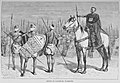 Image 8Group of Kanem-Bu warriors. The Kanem–Bornu Empire controlled almost all of what is today Chad. (from Chad)
 Image 9A Chadian soldier fighting for Free France during World War II. The Free French Forces included 15,000 soldiers from Chad. (from Chad)
 Image 11Despite internal political opposition, coup attempts, and a civil war, Idriss Déby continuously ruled Chad from 1990 until his death in 2021. (from Chad)
 Image 13Fried or Grilled Grasshoppers (from Chad)
 Image 14Mboum girls dancing in Chad (from Chad)


.svg)


.JPG)


Operation Grandslam was an offensive undertaken by United Nations peacekeeping forces from 28 December 1962 to 15 January 1963 against the forces of the State of Katanga, a secessionist state rebelling against the Republic of the Congo (now the Democratic Republic of the Congo) in Central Africa. The Katangese forces were decisively defeated and Katanga was forcibly reintegrated into the Congo.
The United Nations had tried several times to reconcile the government of the Congo with the State of Katanga, which had declared independence under Moïse Tshombe with Belgian support in 1960. Though initially limiting its actions, the United Nations Operation in the Congo became increasingly impatient towards Katanga and Tshombe, drawing up plans to resolve the situation through force. Tshombe continuously violated agreements he had made with the United Nations and the Congolese government by building up his forces and bringing foreign mercenaries into the conflict. The situation reached a breaking point in December 1962 when Katangese gendarmes attacked peacekeeping forces in Katanga. United Nations Secretary-General U Thant authorised a retaliatory offensive to eliminate secessionist opposition. (Full article...)

 Image 1People fleeing their villages due to fighting between FARDC and rebel groups, North Kivu, 2012 (from Democratic Republic of the Congo)
 Image 3Map of rail network (from Democratic Republic of the Congo)
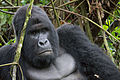 Image 4The endangered mountain gorilla; half of its population live in the DRC's Virunga National Park, making the park a critical habitat for these animals. (from Democratic Republic of the Congo)
 Image 5Development of life expectancy in the Democratic Republic of the Congo (from Democratic Republic of the Congo)
 Image 6DR Congo's Human Development Index scores, 1970–2010. (from Democratic Republic of the Congo)
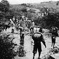 Image 7Force Publique soldiers in the Belgian Congo in 1918. At its peak, the Force Publique had around 19,000 Congolese soldiers, led by 420 Belgian officers. (from Democratic Republic of the Congo)
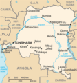 Image 8The map of the Democratic Republic of the Congo (from Democratic Republic of the Congo)
 Image 9Democratic Republic of the Congo's population between 1960 and 2017. (from Democratic Republic of the Congo)
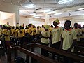 Image 10Roman Catholic Church in the Democratic Republic of the Congo (from Democratic Republic of the Congo)
 Image 11Ugandan President Idi Amin Visits Zaire and Meets Mobutu during The Shaba I Conflict (from History of the Democratic Republic of the Congo)
 Image 12Congo Free State official Camille Coquilhat with the Bangala chief Mata-Buiké in c. 1888 (from Democratic Republic of the Congo)
 Image 13Breakdown of the largest ethnic groups in DRC (from Democratic Republic of the Congo)
 Image 14Patrice Lumumba, first democratically elected Prime Minister of the Congo-Léopoldville, was murdered by Belgian-supported Katangan separatists in 1961. (from Democratic Republic of the Congo)
 Image 15Ndeemba Mask (from Culture of the Democratic Republic of the Congo)
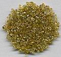 Image 16Rough diamonds ≈1 to 1.5 mm in size from DR Congo (from Democratic Republic of the Congo)
 Image 17The leader of ABAKO, Joseph Kasa-Vubu, first democratically elected President of Congo-Léopoldville (from Democratic Republic of the Congo)
 Image 18Joseph Kabila was President of the Democratic Republic of the Congo from January 2001 to January 2019. (from Democratic Republic of the Congo)
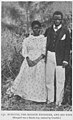
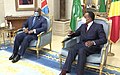 Image 20President Félix Tshisekedi with the president of neighbouring Republic of the Congo Denis Sassou Nguesso in 2020; both wear face masks due to the ongoing COVID-19 pandemic. (from Democratic Republic of the Congo)
 Image 21A group of demobilized child soldiers in the Democratic Republic of the Congo (from Democratic Republic of the Congo)
 Image 22A map of the major Bantu languages in the Democratic Republic of the Congo (from Culture of the Democratic Republic of the Congo)
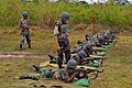 Image 23Congolese soldiers being trained by UN personnel. (from Democratic Republic of the Congo)
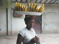 Image 24A woman carrying bananas. (from Culture of the Democratic Republic of the Congo)
 Image 25Population fleeing their villages due to fighting between FARDC and rebels groups, Sake North Kivu 30 April 2012 (from Democratic Republic of the Congo)
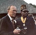 Image 28Mobutu with the Dutch Prince Bernhard in Kinshasa in 1973 (from Democratic Republic of the Congo)
- Image 30The four Bantu languages with elevated "national" status. (from Democratic Republic of the Congo)
 Image 31Democratic Republic of the Congo map of Köppen climate classification (from Democratic Republic of the Congo)
 Image 32Kasaï-Central province, where the Kamwina Nsapu militia clashes with security forces began. (from History of the Democratic Republic of the Congo)
 Image 33Branhamist worshippers in Kinshasa (from Culture of the Democratic Republic of the Congo)
 Image 34President Joseph Kabila with U.S. President Barack Obama in August 2014 (from Democratic Republic of the Congo)
 Image 35A classroom in the Democratic Republic of the Congo. (from Democratic Republic of the Congo)
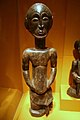
 Image 37A Congolese Christian. (from Culture of the Democratic Republic of the Congo)
 Image 38Flag of CNDP (from History of the Democratic Republic of the Congo)
 Image 40Children mutilated during King Leopold II's rule (from History of the Democratic Republic of the Congo)
 Image 41Memory Board (lukasa) - Luba Kingdom (from Culture of the Democratic Republic of the Congo)
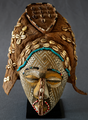 Image 42Masque féminin Ngaady a mwaash, XIX-XXe siècles (from Culture of the Democratic Republic of the Congo)
 Image 43Patrice Lumumba, founding member and leader of the MNC (from History of the Democratic Republic of the Congo)
 Image 44Change in per capita GDP of Congo, 1950–2018. Figures are inflation-adjusted to 2011 International dollars. (from Democratic Republic of the Congo)
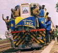 Image 45Train from Lubumbashi arriving in Kindu on a newly refurbished line. (from Democratic Republic of the Congo)
 Image 46Map of the Kingdom of Kongo (from History of the Democratic Republic of the Congo)

 Image 49Mobutu Sese Seko (from History of the Democratic Republic of the Congo)
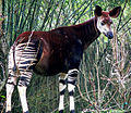 Image 50Found in the Congolian rainforests, the okapi was unknown to science until 1901 (from Democratic Republic of the Congo)
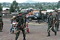 Image 51Government troops near Goma during the M23 rebellion in May 2013 (from Democratic Republic of the Congo)
 Image 52Refugees in the Congo (from Democratic Republic of the Congo)
 Image 53Mobutu Sese Seko and Richard Nixon in Washington, D.C., 1973. (from Democratic Republic of the Congo)
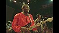 Image 54Franco Luambo and his OK Jazz orchestra performing live at Zaire 74 (from Democratic Republic of the Congo)
.jpg)


_–_Virunga_National_Park_(29).jpg)


_(14577176430).jpg)


_(8458935824).jpg)


.jpg)

.jpg)
.jpg)


_-_Kasaï-Central.svg)


_of_clashes_between_M23_and_National_troops._(8782972992).jpg)


 Image 1An 1894 stamp of Obock. During its time as a French colony, Obock issued its own postage stamps.
 Image 2A satellite image of Djibouti (2011)
 Image 5A view of Randa, Djibouti, 2016
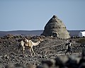 Image 6A local villager and his camel pass in front of the nearly complete eco dome project at Karabti San, Djibouti, November 2012,. U.S. service members assigned to Combined Joint Task Force-Horn of Africa worked with local villagers to build the 21-foot-tall structure, which will serve as the village’s community building.
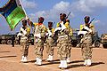 Image 8Members of the Djibouti Army stand at attention at the closing ceremonies of the multi-national, Eastern Africa Standby Force Field Training Exercise in Grand Bara, Djibouti, 4 December 2009.
 Image 10A view of Ghoubbet-el-Kharab (قبة الخراب, "the Gulf of the Demons"), a Djiboutian cove separated from the Gulf of Tadjoura by a violent current
 Image 11A map of Djibouti (2012)
 Image 12A panoramic view of Lake Assal


_(8224423530).jpg)


 Image 1Eritrea's main exports, 2013 (from History of Eritrea)


 Image 5The National Museum of Eritrea is a national museum in Asmara, Eritrea (from Culture of Eritrea)
 Image 7Bahta Hagos was an important leader of the Eritrean resistance to foreign domination specifically against northern Ethiopian and Italian colonialism. (from History of Eritrea)
 Image 10Some of the buildings of the Christian monastery complex in Eritrea was built during 1350s but is much older than the oldest monastery Debre Sina (monastery) from 4th century (from History of Eritrea)
 Image 12Bronze oil lamp excavated at Matara, dating from the Kingdom of Dʿmt (1st century BCE or earlier) (from History of Eritrea)
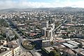
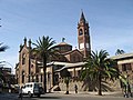
 Image 15Massawa's Sheikh Hanafi Mosque, built in the 15th century under Emperor Zara Yacob (from History of Eritrea)


_crowned.svg)


.jpg)


.jpg)
.jpg)


 Image 3A view of Janjanbureh, Gambia
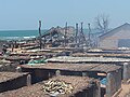 Image 4Fish being smoked in Tanji
 Image 5Life in Serekunda
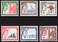 Image 6Gambian postage stamps from 1953
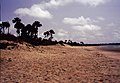 Image 7Gunjur is a small coastal town in south-western Gambia.
- Image 8Banjul International Airport
 Image 9Front and back view of the Gambian dalasi and coins from 5 bututs to 1 dalasi
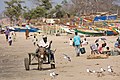 Image 10A donkey cart at a beach in The Gambia
 Image 11Traders at a fish market on the Gambian coast


La Tante DC10 Restaurant, known locally as The Green Plane, is a public–private partnership restaurant established in Accra. This operates from the defunct Ghana Airways McDonnell Douglas DC-10, which had been in operation as a passenger jet between 1983 and 2005. The restaurant serves staple Ghanaian dishes. The restaurant has been well received locally. (Full article...)

 Image 1A view of the bay in Akwida
 Image 2A view of the beach at Elmina
 Image 3Elmina Castle is located in the town of Elmina in the Central Region, situated on a south-facing bay on the Atlantic Ocean coast of Ghana, about 12 km west of Cape Coast. The first European settlement in West Africa, the castle was erected by Portugal in 1482 as São Jorge da Mina (St. George of the Mine) Castle, also known simply as Mina or Feitoria da Mina) in present-day Elmina, Ghana (formerly the Gold Coast).
 Image 4Black Star Square, also known as Independence Square, is a public space located in Accra, Greater Accra Region of Ghana.
 Image 5A view of Elmina
 Image 6Lake Volta is the largest artificial reservoir in the world in terms of surface area, and is contained behind the Akosombo Dam. It is completely within the country of Ghana and has a surface area of 8,502 square kilometres (3,283 sq mi).
 Image 7The beach at a resort in Ada Foah
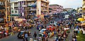 Image 9Street life in Accra
 Image 10A view of the highway in Kumasi
 Image 11Fort Amsterdam is located in the village of Abandze near the Atlantic Ocean coast of Ghana, lying north-east of Cape Coast in the Central Region of Ghana. Fort Amsterdam is a fort that was built by the English between 1638 and 1645 as Fort Cormantine or Fort Courmantyne, and was captured by admiral Engel de Ruyter of the Dutch West India Company in 1665. It was subsequently made part of the Dutch Gold Coast, and remained part of it until the fort was traded with the British in 1868.
 Image 12Street life in Tamale, Ghana, 2015
 Image 13A relief map of Ghana, 2007
 Image 14Part of the bus mass transit system in Kumasi
 Image 16President Barack Obama shakes hands at the departure ceremony at Accra airport in Ghana, July 11, 2009
 Image 17A view of Accra in 1925, from the top of the Lighthouse on James Town Point (open full image for key)
 Image 18Fort Kumasi and Military Museum in Kumasi
 Image 19A view of the landscape near Tongo, 2008
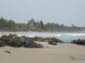
 Image 21A view on the Volta River
 Image 22Adomi Bridge is a bridge in West Africa that spans the Volta River
 Image 24A view of Takoradi in 1920, a village at that time
 Image 25A view of Cape Coast, 2010

.jpg)


.jpg)


.jpg)


- See the Wiki Loves Africa in Ghana category at Wikimedia Commons for more images of Ghana.
(More information)
{{Ghana topics}}
{{Airports in Ghana}}
{{The Big Six}}
{{Ghana district capitals}}
{{Christianity in Ghana}}
{{Chief justices of Ghana}}
{{Colleges of Education in Ghana}}
{{Ghanaian diaspora}}
{{Economy of Ghana}}
{{Ethnic groups of Ghana}}
{{Health in Ghana}}
{{Ghana eye care}}
{{Ghanaian elections}}
{{Ghana governments}}
{{Gold Coast}}
{{Governors of Bank of Ghana}}
{{Ghana high schools}}
{{Regional Hospitals of Ghana}}
{{Ghanaian intelligence agencies}}
{{International schools in Ghana}}
{{Languages of Ghana}}
{{Markets in Ghana}}
{{Military of Ghana}}
{{Ministries and Agencies in Ghana}}
{{National Parks of Ghana}}
{{National sports teams of Ghana}}
{{Petroleum industry in Ghana}}
{{Ghana order of precedence}}
The time allocated for running scripts has expired.
The time allocated for running scripts has expired.
The time allocated for running scripts has expired.
The time allocated for running scripts has expired.
The time allocated for running scripts has expired.
The time allocated for running scripts has expired.
The time allocated for running scripts has expired.
The time allocated for running scripts has expired.
The time allocated for running scripts has expired.
The time allocated for running scripts has expired.
The time allocated for running scripts has expired.
The time allocated for running scripts has expired.
- See the following category pages at Wikimedia Commons for more images of Guinea-Bissau.
- Wiki Loves Africa 2017 in Guinea-Bissau
- Wiki Loves Africa 2015 in Guinea-Bissau
The time allocated for running scripts has expired. The time allocated for running scripts has expired.
The time allocated for running scripts has expired.
The time allocated for running scripts has expired.
The time allocated for running scripts has expired.
The time allocated for running scripts has expired.
The time allocated for running scripts has expired.
The time allocated for running scripts has expired.
The time allocated for running scripts has expired. The time allocated for running scripts has expired.
The time allocated for running scripts has expired. The time allocated for running scripts has expired.
The time allocated for running scripts has expired. The time allocated for running scripts has expired.
The time allocated for running scripts has expired. The time allocated for running scripts has expired.
The time allocated for running scripts has expired. The time allocated for running scripts has expired.
The time allocated for running scripts has expired. The time allocated for running scripts has expired.
The time allocated for running scripts has expired.
The time allocated for running scripts has expired.
The time allocated for running scripts has expired.
The time allocated for running scripts has expired.
The time allocated for running scripts has expired.
The time allocated for running scripts has expired. The time allocated for running scripts has expired.
The time allocated for running scripts has expired. The time allocated for running scripts has expired.
The time allocated for running scripts has expired. The time allocated for running scripts has expired.
The time allocated for running scripts has expired. The time allocated for running scripts has expired.
The time allocated for running scripts has expired. The time allocated for running scripts has expired.
The time allocated for running scripts has expired.
The time allocated for running scripts has expired.
The time allocated for running scripts has expired.
The time allocated for running scripts has expired.
The time allocated for running scripts has expired.
The time allocated for running scripts has expired.
The time allocated for running scripts has expired.
The time allocated for running scripts has expired.
The time allocated for running scripts has expired.
- For images and videos of Nigeria, see the Wiki Loves Africa in Nigeria category at Wikimedia Commons.
The time allocated for running scripts has expired. The time allocated for running scripts has expired. The time allocated for running scripts has expired. The time allocated for running scripts has expired. The time allocated for running scripts has expired. The time allocated for running scripts has expired. The time allocated for running scripts has expired. The time allocated for running scripts has expired. The time allocated for running scripts has expired.
The time allocated for running scripts has expired.
The time allocated for running scripts has expired.
The time allocated for running scripts has expired.
The time allocated for running scripts has expired. The time allocated for running scripts has expired. The time allocated for running scripts has expired. The time allocated for running scripts has expired. The time allocated for running scripts has expired. The time allocated for running scripts has expired. The time allocated for running scripts has expired. The time allocated for running scripts has expired. The time allocated for running scripts has expired. The time allocated for running scripts has expired. The time allocated for running scripts has expired. The time allocated for running scripts has expired. The time allocated for running scripts has expired.
The time allocated for running scripts has expired. The time allocated for running scripts has expired. The time allocated for running scripts has expired. The time allocated for running scripts has expired. The time allocated for running scripts has expired. The time allocated for running scripts has expired. The time allocated for running scripts has expired.
The time allocated for running scripts has expired.
The time allocated for running scripts has expired.
The time allocated for running scripts has expired.
The time allocated for running scripts has expired.
The time allocated for running scripts has expired.
The time allocated for running scripts has expired. The time allocated for running scripts has expired. The time allocated for running scripts has expired. The time allocated for running scripts has expired. The time allocated for running scripts has expired. The time allocated for running scripts has expired. The time allocated for running scripts has expired. The time allocated for running scripts has expired. The time allocated for running scripts has expired. The time allocated for running scripts has expired. The time allocated for running scripts has expired.
The time allocated for running scripts has expired.
The time allocated for running scripts has expired.
The time allocated for running scripts has expired.
The time allocated for running scripts has expired.
The time allocated for running scripts has expired.
The time allocated for running scripts has expired.
The time allocated for running scripts has expired.
The time allocated for running scripts has expired.
The time allocated for running scripts has expired.
- See Wiki Loves Africa in Somalia at Wikimedia Commons for more Somalia images.
The time allocated for running scripts has expired. The time allocated for running scripts has expired. The time allocated for running scripts has expired. The time allocated for running scripts has expired. The time allocated for running scripts has expired. The time allocated for running scripts has expired. The time allocated for running scripts has expired. The time allocated for running scripts has expired. The time allocated for running scripts has expired. The time allocated for running scripts has expired. The time allocated for running scripts has expired. The time allocated for running scripts has expired. The time allocated for running scripts has expired. The time allocated for running scripts has expired. The time allocated for running scripts has expired. The time allocated for running scripts has expired. The time allocated for running scripts has expired.
The time allocated for running scripts has expired.
The time allocated for running scripts has expired.
The time allocated for running scripts has expired.
The time allocated for running scripts has expired.
The time allocated for running scripts has expired.
The time allocated for running scripts has expired.
The time allocated for running scripts has expired.
The time allocated for running scripts has expired. The time allocated for running scripts has expired. The time allocated for running scripts has expired. The time allocated for running scripts has expired. The time allocated for running scripts has expired. The time allocated for running scripts has expired. The time allocated for running scripts has expired. The time allocated for running scripts has expired. The time allocated for running scripts has expired. The time allocated for running scripts has expired. The time allocated for running scripts has expired.
The time allocated for running scripts has expired.
The time allocated for running scripts has expired.
The time allocated for running scripts has expired.
The time allocated for running scripts has expired.
The time allocated for running scripts has expired.
The time allocated for running scripts has expired.
The time allocated for running scripts has expired.
The time allocated for running scripts has expired.
The time allocated for running scripts has expired.
The time allocated for running scripts has expired.
The time allocated for running scripts has expired.
The time allocated for running scripts has expired.
The time allocated for running scripts has expired.
The time allocated for running scripts has expired.
The time allocated for running scripts has expired.
The time allocated for running scripts has expired.
LEFT The time allocated for running scripts has expired. The time allocated for running scripts has expired.
RIGHT The time allocated for running scripts has expired. The time allocated for running scripts has expired.
{{subst:box portal skeleton}}
The time allocated for running scripts has expired.
The time allocated for running scripts has expired.
User:Northamerica1000/Portals of the world/box-header User:Northamerica1000/Portals of the world/Intro
The time allocated for running scripts has expired.
The time allocated for running scripts has expired.
User:Northamerica1000/Portals of the world/box-header User:Northamerica1000/Portals of the world/News
The time allocated for running scripts has expired.
User:Northamerica1000/Portals of the world/box-header User:Northamerica1000/Portals of the world/Did you know
User:Northamerica1000/Portals of the world/box-header User:Northamerica1000/Portals of the world/Categories
User:Northamerica1000/Portals of the world/box-header User:Northamerica1000/Portals of the world/Topics
User:Northamerica1000/Portals of the world/box-header User:Northamerica1000/Portals of the world/Related portals
User:Northamerica1000/Portals of the world/box-header User:Northamerica1000/Portals of the world/Projects
User:Northamerica1000/Portals of the world/box-header User:Northamerica1000/Portals of the world/Opentask
User:Northamerica1000/Portals of the world/box-header User:Northamerica1000/Portals of the world/Wikimedia
The time allocated for running scripts has expired. Purge server cache __NOTOC__ __NOEDITSECTION__