Dosiero:Korean_war_1950-1953.gif
From Wikipedia, the free encyclopedia
Grandeco de ĉi antaŭvido: 387 × 600 rastrumeroj. Aliaj distingivoj: 155 × 240 rastrumeroj | 562 × 871 rastrumeroj.
Bildo en pli alta difino ((562 × 871 rastrumeroj, grandeco de dosiero: 1,32 MB, MIME-tipo: image/gif), ripeta GIF, 20 ĉeloj, 30 s)
| Jen dosiero de la Wikimedia-Komunejo. La priskribo en ties priskriba paĝo estas montrata suben.
|
| The image contains one or several undisputed inaccuracies.
It should not be used to illustrate or provide information about the subject, but may be kept in order to provide the basis for a corrected image. If you disagree that it may be useful for this purpose feel free to request deletion. Reason:
Issue A: 07.1953 map (end of the gif) is definitely inaccurate because: (1) the July 1953 armistice includes the following statement: "all the islands lying to the north and west of the provincial boundary line between HWANGHAE-DO and KYONGGI-DO shall be under the military control of the Supreme Commander of the Korean People's Army and the Commander of the Chinese People's volunteers, except the island groups of PAENGYONG-DO (37 58' N, 124 40' E), TAECHONG-DO (37 50' N, 124 42' E), SOCHONG-DO (37 46' N, 124 46' E), YONPYONG-DO (37 38' N, 125 40' E), and U-DO (37 36'N, 125 58' E), which shall remain under the military control of the Commander-in-Chief, United Nations Command." and (2) the island Baengnyeongdo (PAENGYONG-DO) is colored pink on the 07.1953 map. We see in the statement above that the island shall remain under UN military control (July 1953) and hence should likely be colored green in the 07.1953 map and possibly other maps. If the lack of precision which causes this error on the 07.1953 map is true of the whole series of maps, then this gif really needs reviewing. Issue B: Ulleungdo, which is larger in land area than the above-mentioned Baengnyeongdo and is part of Korea, should be part of this map, and not including it is an error. Why ignore a part of Korean territory? |
Resumo
| PriskriboKorean war 1950-1953.gif |
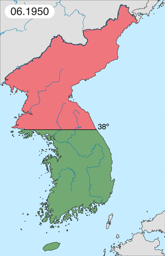
English: Map of Korean war from May 1950 to July 1951, showing:
Français : Carte de la guerre de Corée de mai 1950 à juillet 1951, montrant:
Deutsch: Karte des Koreakriegs von Mai 1950 bis Juli 1951, abgebildet:
Italiano: Mappa della guerra di Corea dal maggio 1950 al luglio 1951, rappresentante:
|
| Dato | |
| Fonto | Propra verko |
| Aŭtoro | Leomonaci98 |
Permesiloj:
Mi, la posedanto de la aŭtorrajto por ĉi tiu verko, ĉi-maniere publikigas ĝin laŭ la jenaj permesiloj:

|
Estas permesite kopii, disdoni kaj/aŭ redakti ĉi tiun dokumenton, sen senŝanĝaj sekcioj, sen antaŭkovrilaj kaj sen dorskovrilaj tekstoj, laŭ la kondiĉoj de la Permesilo GNU por Liberaj Dokumentoj, Versio 1.2 aŭ ajna pli nova versio eldonita de la Free Software Foundation; sen Senŝanĝaj Sekcioj, Antaŭovrilaj Tekstoj aŭ Malantaŭkovrilaj Tekstoj. Kopio de la permesilo estas inkluzivita en la sekcio titolita GNU Free Documentation License.http://www.gnu.org/copyleft/fdl.htmlGFDLGNU Free Documentation Licensetruetrue |
| Ĉi tiu dosiero estas disponebla laŭ la permesilo Krea Komunaĵo Atribuite-Samkondiĉe 3.0 Neadaptita. | ||
| ||
| Ĉi tiu permesila etikedo estis aldonita al la dosiero kiel parto de la permesila aktualigo por GFDL.http://creativecommons.org/licenses/by-sa/3.0/CC BY-SA 3.0Creative Commons Attribution-Share Alike 3.0truetrue |
Vi povas elekti la permesilon preferatan.
Titoloj
Donu unulinian priskribon de la enhavo de ĉi tiu dosiero
It represents the land Korea gained
Kore'nin kazandığı toprakları teslim ediyor
Eroj prezentitaj en ĉi tiu dosiero
montras
Iu valoro sen Vikidatumoj ero
5 jun. 2006
image/gif
Dosierhistorio
Alklaku iun daton kaj horon por vidi kiel la dosiero tiam aspektis.
| Dato/Horo | Bildeto | Grandecoj | Uzanto | Komento | |
|---|---|---|---|---|---|
| nun | 20:20, 16 feb. 2020 | | 562 × 871 (1,32 MB) | Leomonaci98 | Graphic update |
| 01:02, 1 maj. 2013 |  | 227 × 400 (85 KB) | Spesh531 | update for every month | |
| 08:47, 9 jun. 2006 |  | 227 × 400 (37 KB) | Roke~commonswiki | rm white | |
| 06:25, 8 jun. 2006 |  | 227 × 400 (37 KB) | Roke~commonswiki | add OngJin peninsula after comment, also blank frame at end | |
| 15:14, 5 jun. 2006 |  | 227 × 400 (37 KB) | Roke~commonswiki | Korean war, showing North Korean, Chinese and communist forces (red); South Korean, US and United Nations forces (green). Category: Korean War Category: Animated maps |
Dosiera uzado
La jenaj paĝoj ligas al ĉi tiu dosiero:
Suma uzado de la dosiero
La jenaj aliaj vikioj utiligas ĉi tiun dosieron:
- Uzado en af.wikipedia.org
- Uzado en az.wikipedia.org
- Uzado en bat-smg.wikipedia.org
- Uzado en bg.wikipedia.org
- Uzado en br.wikipedia.org
- Uzado en bs.wikipedia.org
- Uzado en ca.wikipedia.org
- Corea del Nord
- Corea del Sud
- Ióssif Stalin
- Mao Zedong
- Winston Churchill
- Harry Truman
- Guerra de Corea
- Kim Il-sung
- Viatxeslav Mólotov
- Gueorgui Malenkov
- Douglas MacArthur
- Lavrenti Béria
- M*A*S*H (pel·lícula)
- Clement Attlee
- Mark Wayne Clark
- Zona desmilitaritzada de Corea
- República Popular d'Hongria
- Syngman Rhee
- Peng Dehuai
- Força Aèria de l'Exèrcit Popular de Corea
- Forces Armades de Corea del Nord
- Forces Armades de la República de Corea
- 65è Regiment d'Infanteria (Estats Units)
- Frontera entre Corea del Nord i Corea del Sud
- Kim Chaek
- Batalla d'Inchon
- Plantilla:Guerra de Corea
- Pak Hon-yong
- Uzado en ckb.wikipedia.org
- Uzado en cs.wikipedia.org
- Uzado en cy.wikipedia.org
- Uzado en da.wikipedia.org
- Uzado en de.wikipedia.org
- Uzado en el.wikipedia.org
- Uzado en en.wikipedia.org
Vidi plian ĝeneralan uzadon de ĉi tiu dosiero.