Fichier:1900_U.S.G.S_Map_of_Huntington_and_Northport,_Long_Island,_New_York_-_Geographicus_-_Northport-uscs-1925.jpg
De Wikipedia, l'encyclopédie encyclopedia
Fichier d’origine (3 000 × 3 896 pixels, taille du fichier : 2,23 Mio, type MIME : image/jpeg)
Ce fichier et sa description proviennent de Wikimedia Commons.
| New York Northport Quadrangle | |||||||
|---|---|---|---|---|---|---|---|
| Artiste | |||||||
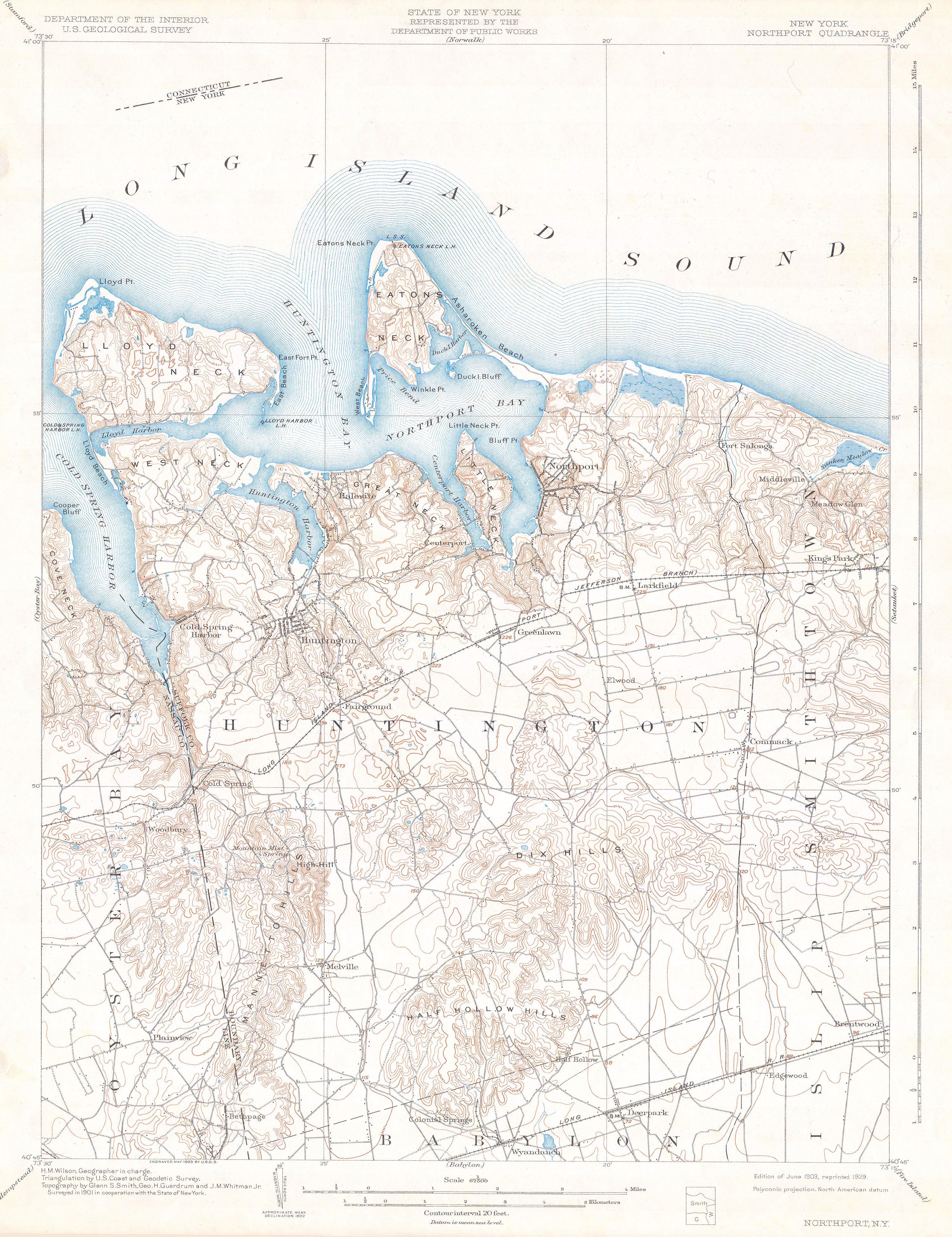
| Titre |
New York Northport Quadrangle |
||||||
| Description |
English: This beautiful and fascinating topographical chart depicts Long Island, New York from Oyster Bay through Huntington and Northport to Smithtown, Islip, and Babylon. Highly detailed with important buildings, and trains and rail lines. A rare and stunning geological survey of this highly populated region. From the 1928 reissue of the Feb. 1900 charts. |
||||||
| Date |
1900 date QS:P571,+1900-00-00T00:00:00Z/9 |
||||||
| Dimensions |
hauteur : 15 pouces (38,1 cm) ; largeur : 19 pouces (48,2 cm) dimensions QS:P2048,15U218593 dimensions QS:P2049,19U218593 |
||||||
| Numéro d’inventaire |
liens Geographicus : Northport-uscs-1925 |
||||||
| Source / photographe |
|
||||||
| Autorisation (Réutilisation de ce fichier) |
|
||||||
Légendes
Éléments décrits dans ce fichier
dépeint
image/jpeg
db5e0bde8671f36d944693c4adceaab29fc780fd
2 340 023 octet
3 896 pixel
3 000 pixel
Historique du fichier
Cliquer sur une date et heure pour voir le fichier tel qu'il était à ce moment-là.
| Date et heure | Vignette | Dimensions | Utilisateur | Commentaire | |
|---|---|---|---|---|---|
| actuel | 12 mars 2011 à 14:50 | | 3 000 × 3 896 (2,23 Mio) | BotMultichill | {{subst:User:Multichill/Geographicus |link=http://www.geographicus.com/P/AntiqueMap/Northport-uscs-1925 |product_name=1900 U.S.G.S Map of Huntington and Northport, Long Island, New York |map_title=New York Northport Quadrangle |description=This beautifu |
Utilisation du fichier
La page suivante utilise ce fichier :