Fichier:Alamannien_Hochburgund_ca_1000.png
De Wikipedia, l'encyclopédie encyclopedia
Fichier d’origine (2 500 × 2 107 pixels, taille du fichier : 1,11 Mio, type MIME : image/png)
Ce fichier et sa description proviennent de Wikimedia Commons.
Description
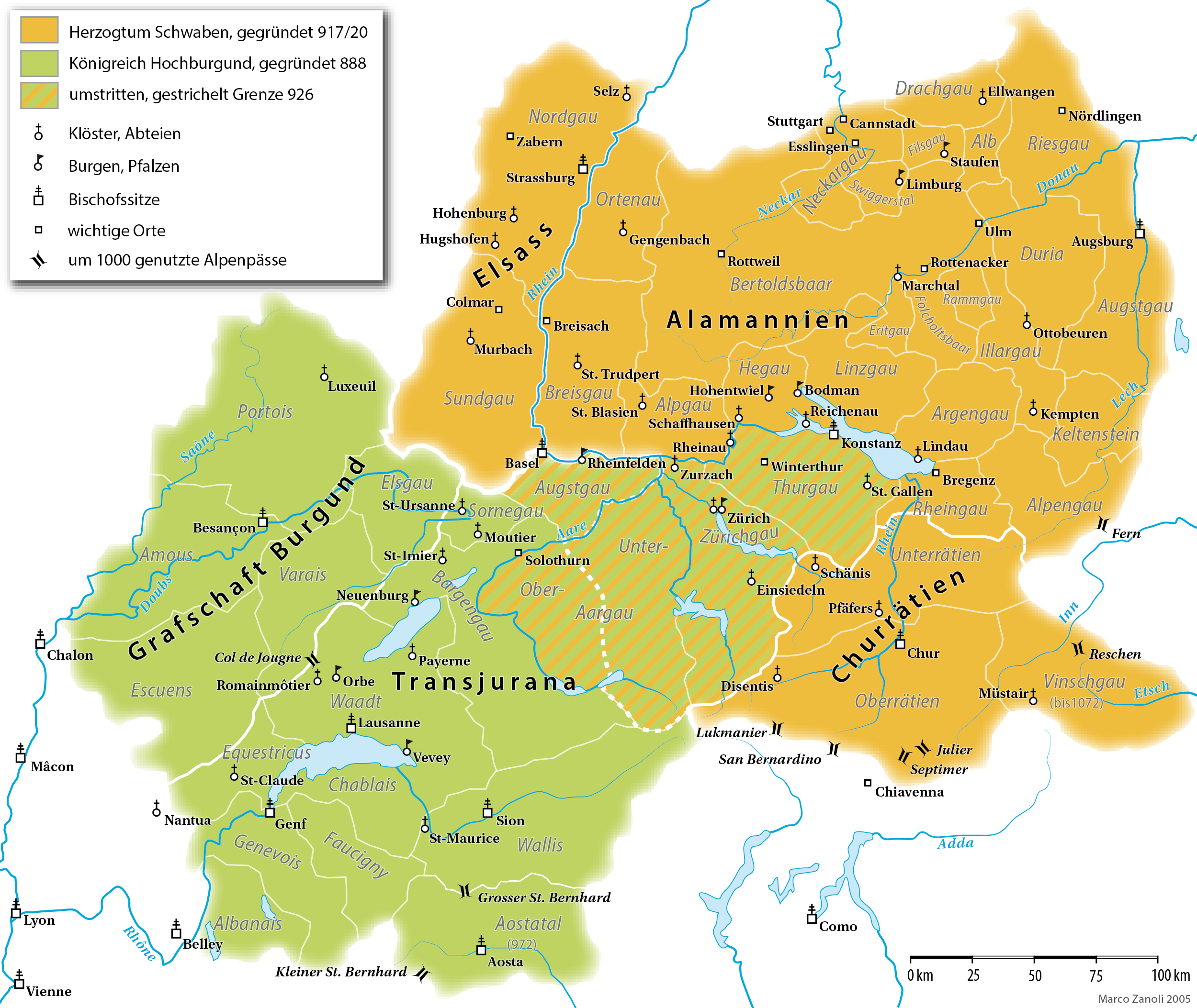
| DescriptionAlamannien Hochburgund ca 1000.png |
English: A map (in German) of the Duchy of Alamannia and the Kingdom of Upper Burgundy in the 10th century. |
| Date | |
| Source | own work; G. Droysen: Allgemeiner Historischer Handatlas. Bielefeld / Leipzig, 1886, 22f. |
| Auteur | Marco Zanoli |
| Autres versions |
|


|
Cette image (de type historical map) devrait être recréée dans un format vectoriel, en tant que fichier SVG. Cela offrirait plusieurs avantages : voir Commons:Media for cleanup pour plus d'informations. Si une version SVG de cette image est déjà disponible, merci de bien vouloir l'envoyer. Après cela, remplacez ce modèle par {{vector version available|nouveau nom d'image.svg}}.
|
Conditions d’utilisation
You may use my work outside wikipedia for free as long as you name me as the author. If you would like to use my work in a print medium, please send me a specimen copy.
Contact me if you have questions regarding the license or if you want individual changes to the map (marco.zanoli at hotmail.ch). Ce fichier est sous la licence Creative Commons Attribution – Partage dans les Mêmes Conditions 4.0 International. Attribution: Marco Zanoli
|
Légendes
Éléments décrits dans ce fichier
dépeint
19 octobre 2005
image/png
4a138300363d4826034bdf815752198014c0d169
1 166 320 octet
2 107 pixel
2 500 pixel
Historique du fichier
Cliquer sur une date et heure pour voir le fichier tel qu'il était à ce moment-là.
| Date et heure | Vignette | Dimensions | Utilisateur | Commentaire | |
|---|---|---|---|---|---|
| actuel | 10 avril 2021 à 18:49 | | 2 500 × 2 107 (1,11 Mio) | Sidonius | Lukmanier und San Bernardino vertauscht |
| 28 mars 2021 à 16:11 |  | 2 500 × 2 107 (1,12 Mio) | Sidonius | kleinere Korrekturen, Gaue auch in Hochburgund in modernen Namen | |
| 15 novembre 2020 à 20:49 |  | 1 500 × 1 319 (550 kio) | FootKalos1597 | Added informations | |
| 19 février 2019 à 10:08 |  | 1 500 × 1 319 (534 kio) | Sidonius | - Chiavenna entfernt, da erst 1157 zu Schwaben | |
| 18 février 2019 à 18:15 |  | 1 500 × 1 319 (535 kio) | Sidonius | - Kloster St-Claude eingezeichnet - Beschriftung weiss hinterlegt - Vinschgau übereinstimmend mit Forschung zu Churrätien als Teil des Hzm. Schwaben eingezeichnet | |
| 20 janvier 2019 à 15:24 |  | 1 500 × 1 319 (414 kio) | Sidonius | - Abtei Hugshofen eingezeichnet - Aostatal als Teil von Hochburgund | |
| 13 janvier 2019 à 16:22 |  | 1 500 × 1 285 (404 kio) | Sidonius | weitere Fehler korrigiert, zusätzliche Orte eingezeichnet, Legende überarbeitet, Grenzen korrigiert gemäss Historischem Lexikon der CH | |
| 12 janvier 2019 à 17:36 |  | 1 500 × 1 288 (392 kio) | Sidonius | kleinere Fehler behoben in Beschriftungen, Farben noch etwas angepasst | |
| 27 novembre 2012 à 01:10 |  | 1 500 × 1 322 (252 kio) | Hawky.diddiz | Lossless optimization | |
| 23 mai 2011 à 13:54 |  | 1 500 × 1 322 (433 kio) | Sidonius | letzter Versuch, die korrigierte Datei einzubinden |
Utilisation du fichier
Les 4 pages suivantes utilisent ce fichier :
Usage global du fichier
Les autres wikis suivants utilisent ce fichier :
- Utilisation sur als.wikipedia.org
- Utilisation sur an.wikipedia.org
- Utilisation sur ar.wikipedia.org
- Utilisation sur arz.wikipedia.org
- Utilisation sur ast.wikipedia.org
- Utilisation sur bg.wikipedia.org
- Utilisation sur br.wikipedia.org
- Utilisation sur ca.wikipedia.org
- Utilisation sur cs.wikipedia.org
- Utilisation sur cy.wikipedia.org
- Utilisation sur de.wikipedia.org
Voir davantage sur l’utilisation globale de ce fichier.
Métadonnées
Ce fichier contient des informations supplémentaires, probablement ajoutées par l'appareil photo numérique ou le numériseur utilisé pour le créer.
Si le fichier a été modifié depuis son état original, certains détails peuvent ne pas refléter entièrement l'image modifiée.
| Résolution horizontale | 170,89 pt/cm |
|---|---|
| Résolution verticale | 170,89 pt/cm |