Fichier:Battle_of_Magersfontein_Map.png
De Wikipedia, l'encyclopédie encyclopedia
Battle_of_Magersfontein_Map.png (425 × 346 pixels, taille du fichier : 18 kio, type MIME : image/png)
Ce fichier et sa description proviennent de Wikimedia Commons.
| DescriptionBattle of Magersfontein Map.png |
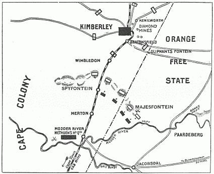
Map showing positions at the Battle of Magersfontein, 11 December 1899.
|
|||||
| Date | ||||||
| Source | "South Africa and the Transvaal War, Vol. 2 (of 6). From the Commencement of the War to the Battle of Colenso" by Louis Creswicke. Published by T. C. & E. C. JACK EDINBURGH, 1900. Downloaded from Project Gutenberg at http://www.gutenberg.org/etext/26198 | |||||
| Auteur | Louis Creswicke | |||||
| Autorisation (Réutilisation de ce fichier) |
Copyright expired.
|
|||||
Légendes
Éléments décrits dans ce fichier
dépeint
image/png
2416f931965b0cd1a8c7e3257896dbf35bfd266f
17 997 octet
346 pixel
425 pixel
Historique du fichier
Cliquer sur une date et heure pour voir le fichier tel qu'il était à ce moment-là.
| Date et heure | Vignette | Dimensions | Utilisateur | Commentaire | |
|---|---|---|---|---|---|
| actuel | 30 août 2008 à 18:15 | | 425 × 346 (18 kio) | Rcbutcher | {{Information |Description=Map showing positions at the Battle of Magersfontein, 11 December 1899. |Source="South Africa and the Transvaal War, Vol. 2 (of 6). From the Commencement of the War to the Battle of Colenso" by Louis Creswicke. Published by T. C |
Utilisation du fichier
Les 2 pages suivantes utilisent ce fichier :
Usage global du fichier
Les autres wikis suivants utilisent ce fichier :
- Utilisation sur ru.wikipedia.org
- Utilisation sur www.wikidata.org