Fichier:Canada_and_partitioned_Quebec_(preferences).png
De Wikipedia, l'encyclopédie encyclopedia
Taille de cet aperçu : 707 × 600 pixels. Autres résolutions : 283 × 240 pixels | 566 × 480 pixels | 904 × 767 pixels.
Fichier d’origine (904 × 767 pixels, taille du fichier : 136 kio, type MIME : image/png)
Ce fichier et sa description proviennent de Wikimedia Commons.
| DescriptionCanada and partitioned Quebec (preferences).png |
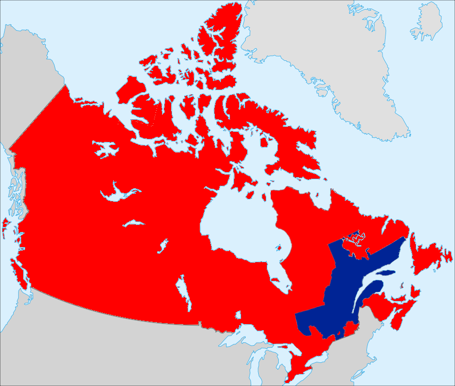
English: A possible map for a partitioned, independent Quebec, shown with Canada, showing the third option from Partition of Quebec, with Montreal, Northern Quebec, the Eastern Townships and the Pontiac RCM remaining with Canada. |
| Date | (UTC) |
| Source | |
| Auteur |
|
| Public domainPublic domainfalsefalse |
| Moi, propriétaire des droits d’auteur sur cette œuvre, la place dans le domaine public. Ceci s'applique dans le monde entier. Dans certains pays, ceci peut ne pas être possible ; dans ce cas : J’accorde à toute personne le droit d’utiliser cette œuvre dans n’importe quel but, sans aucune condition, sauf celles requises par la loi. |
Journal des téléversements d’origine
This image is a derivative work of the following images:
- File:Québec,_Canada.svg licensed with PD-self
- 2008-09-29T06:05:35Z EOZyo 1084x920 (94991 Bytes) {{Information |Description={{en|1=Québec Province within Canada.}} {{es|1=Provincia de Quebec en Canadá.}} |Source=Based on [[:Image:Canada (geolocalisation).svg]] |Author=[[User:EOZyo|EOZyo]] |Date=2008-09-29 |Permission=
- File:Qc_Pontiac.png licensed with PD-self
- 2008-05-29T09:12:46Z Nichtbesserwisser 920x1160 (35293 Bytes) {{Information |Description={{en|1=MRC Pontiac, Quebec}} |Source=Own work by uploader |Author=[[User:Nichtbesserwisser|Nichtbesserwisser]] |Date=29 May 2008 |Permission= |other_versions= }} [[Category:Map
Téléversé avec derivativeFX
Légendes
Ajoutez en une ligne la description de ce que représente ce fichier
Éléments décrits dans ce fichier
dépeint
16 juillet 2009
image/png
10f2667acee7dc24a08b65e9be0048f26b928ba4
139 579 octet
767 pixel
904 pixel
Historique du fichier
Cliquer sur une date et heure pour voir le fichier tel qu'il était à ce moment-là.
| Date et heure | Vignette | Dimensions | Utilisateur | Commentaire | |
|---|---|---|---|---|---|
| actuel | 16 juillet 2009 à 14:58 | | 904 × 767 (136 kio) | OwenBlacker | {{Information |Description={{en|1=A possible map for a partitioned, independent en:Quebec, shown with en:Canada, showing the third option from en:Partition of Quebec, with en:Montreal, Northern Quebec, the [ |
Utilisation du fichier
La page suivante utilise ce fichier :
Ce document provient de « https://fr.wikipedia.org/wiki/Fichier:Canada_and_partitioned_Quebec_(preferences).png ».
.png)