Fichier:Empire_State_Building_from_the_Top_of_the_Rock.jpg
De Wikipedia, l'encyclopédie encyclopedia
Taille de cet aperçu : 447 × 600 pixels. Autres résolutions : 179 × 240 pixels | 358 × 480 pixels | 756 × 1 014 pixels.
Fichier d’origine (756 × 1 014 pixels, taille du fichier : 741 kio, type MIME : image/jpeg)
Ce fichier et sa description proviennent de Wikimedia Commons.
Description
| DescriptionEmpire State Building from the Top of the Rock.jpg |
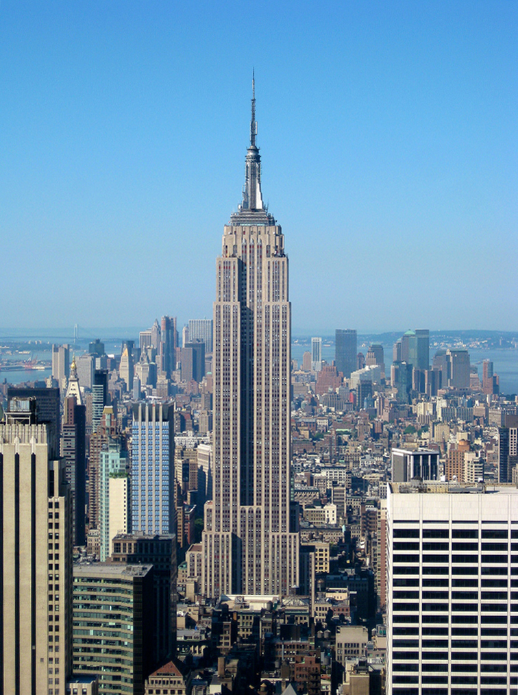
English: The Empire State Building is a 102-story landmark Art Deco skyscraper in New York City at the intersection of Fifth Avenue and West 34th Street. Its name is derived from the nickname for the state of New York, The Empire State. It stood as the world's tallest building for more than forty years, from its completion in 1931 until construction of the World Trade Center's North Tower was completed in 1972. Following the destruction of the World Trade Center in 2001, the Empire State Building once again became the tallest building in New York City and New York State. |
| Date | |
| Source | originally posted to Flickr as Empire State Building from the Top of the Rock |
| Auteur | Jiuguang Wang |
| Autres versions |
  |
Conditions d’utilisation
- Objet
| Public domainPublic domainfalsefalse |
United States copyright law does not protect architectural works before 1er décembre 1990. In 1990, the Architectural Works Copyright Protection Act amended subsection 102(a) of the US copyright law by adding paragraph (8), "architectural works." A building that was substantially constructed or for which the plans were otherwise published before 1er décembre 1990, is in the public domain in the United States.
For images of architectural works in the United States completed on or after 1er décembre 1990, please use {{FoP-US}} on the description pages of the images. English | español | Deutsch | italiano | македонски | sicilianu | slovenščina | +/− |
 |
- Photographie
| Cette image, qui provient de Flickr, a été importée sur Commons à l’aide du Flickr upload bot le 14 juillet 2010, 15:22 par Avala. À cette date, elle était publiée sous la licence suivante. |
Ce fichier est disponible selon les termes de la licence Creative Commons Attribution – Partage dans les Mêmes Conditions 2.0 Générique
- Vous êtes libre :
- de partager – de copier, distribuer et transmettre cette œuvre
- d’adapter – de modifier cette œuvre
- Sous les conditions suivantes :
- paternité – Vous devez donner les informations appropriées concernant l'auteur, fournir un lien vers la licence et indiquer si des modifications ont été faites. Vous pouvez faire cela par tout moyen raisonnable, mais en aucune façon suggérant que l’auteur vous soutient ou approuve l’utilisation que vous en faites.
- partage à l’identique – Si vous modifiez, transformez, ou vous basez sur cette œuvre, vous devez distribuer votre contribution sous la même licence ou une licence compatible avec celle de l’original.
Légendes
Ajoutez en une ligne la description de ce que représente ce fichier
Amanath, Manoj Unnithan
Empire State Building kuvattuna Top of the Rock -näköalatasanteelta Rockefeller Centeristä.
Éléments décrits dans ce fichier
dépeint
31 mai 2010
Historique du fichier
Cliquer sur une date et heure pour voir le fichier tel qu'il était à ce moment-là.
| Date et heure | Vignette | Dimensions | Utilisateur | Commentaire | |
|---|---|---|---|---|---|
| actuel | 1 mai 2016 à 00:08 | | 756 × 1 014 (741 kio) | Jacek Halicki | tilt |
| 14 juillet 2010 à 17:22 |  | 768 × 1 024 (518 kio) | Flickr upload bot | Uploaded from http://flickr.com/photo/32366606@N00/4758542305 using Flickr upload bot |
Utilisation du fichier
Les 81 pages suivantes utilisent ce fichier :
- Alphabet City
- Ansonia (Manhattan)
- Battery Park City
- Bowery
- Carnegie Hill
- Central Harlem
- Chelsea (Manhattan)
- Chinatown (Manhattan)
- Civic Center (Manhattan)
- Columbus Circle
- Cooperative Village
- Diamond District
- East Harlem
- East Village
- Ellis Island
- Financial District (Manhattan)
- Five Points (Manhattan)
- Flatiron District
- Garment District
- Governors Island
- Gramercy Park
- Greenwich Village
- Hamilton Heights
- Harlem
- Hell's Kitchen
- Herald Square
- Hudson Heights
- Inwood
- Kips Bay
- Koreatown (Manhattan)
- Liberty Island
- Lincoln Square (Manhattan)
- Liste des National Historic Landmarks de New York
- Liste des quartiers de New York
- Little Germany
- Little Italy (New York)
- Little Spain
- Little Syria
- Loisaida
- Lower East Side
- Lower Manhattan
- Madison Square
- Manhattan
- Manhattan Valley
- Manhattanville
- Marble Hill
- Meatpacking District
- Midtown (Manhattan)
- Morningside Heights
- Mulberry Bend
- Murray Hill
- NoHo (Manhattan)
- NoLIta
- Peter Cooper Village
- Pierre naturelle
- Radio Row
- Randall's Island
- Roosevelt Island
- San Juan Hill
- SoHo
- South Street Seaport
- Stuyvesant Town
- Sugar Hill (New York)
- Sutton Place
- Tenderloin (New York)
- Theater District
- Times Square
- Tribeca
- Tudor City
- Turtle Bay
- Two Bridges
- Union Square (New York)
- Upper East Side
- Upper Manhattan
- Upper West Side
- Ward's Island
- Washington Heights
- West Harlem
- West Village
- Yorkville (Manhattan)
- Modèle:Palette Quartiers de Manhattan
Usage global du fichier
Les autres wikis suivants utilisent ce fichier :
- Utilisation sur af.wikipedia.org
- Utilisation sur als.wikipedia.org
- Utilisation sur arz.wikipedia.org
- Utilisation sur az.wikipedia.org
- Utilisation sur az.wiktionary.org
- Utilisation sur ba.wikipedia.org
- Utilisation sur bg.wikipedia.org
- Utilisation sur bn.wikipedia.org
- Utilisation sur ca.wikipedia.org
- Utilisation sur ce.wikipedia.org
- Utilisation sur cs.wikipedia.org
- Utilisation sur cy.wikipedia.org
- Utilisation sur de.wikipedia.org
- Empire State Building
- Wikipedia Diskussion:Hauptseite/Jahrestage/Archiv
- New York City
- Vorlage:Infobox Hochhaus
- Grünes Gebäude
- Liste der höchsten Gebäude in New York
- Wikipedia:Kandidaten für exzellente Bilder/Archiv2011/1
- Vorlage:Infobox Hochhaus/Doku
- Wikipedia:Löschkandidaten/21. Juli 2017
- Diskussion:Fernmeldeturm Kiel/Archiv
- Evelyn McHale
- Utilisation sur el.wikipedia.org
- Utilisation sur en.wikipedia.org
- 1930s
- Wikipedia:Unusual articles
- Setback (architecture)
- Efficient energy use
- User:Mariordo
- 1931 in the United States
- User:Presidentman/potd/4 December 2011
- User:Jay Myers (Hurricane Jay)/userboxing/empire state building
- User:Jay Myers (Hurricane Jay)/userboxing/empire state building floor
- 2012 Empire State Building shooting
- Phallic architecture
- Chicago Pneumatic
- Wikipedia:Unusual articles/Popular culture, entertainment and the arts
- User:Serendipodous/sandbox/2
- List of skyscrapers by floor area
- Utilisation sur en.wikiquote.org
- Utilisation sur en.wikivoyage.org
- Utilisation sur eo.wikipedia.org
Voir davantage sur l’utilisation globale de ce fichier.
Métadonnées
Ce fichier contient des informations supplémentaires, probablement ajoutées par l'appareil photo numérique ou le numériseur utilisé pour le créer.
Si le fichier a été modifié depuis son état original, certains détails peuvent ne pas refléter entièrement l'image modifiée.
| Largeur | 768 px |
|---|---|
| Hauteur | 1 024 px |
| Bits par composante |
|
| Composition des pixels | RVB |
| Titre de l’image |
|
| Orientation | Normale |
| Nombre de composantes | 3 |
| Résolution horizontale | 180 pt/po |
| Résolution verticale | 180 pt/po |
| Logiciel utilisé | Adobe Photoshop CS6 (Windows) |
| Date de modification du fichier | 1 mai 2016 à 00:07 |
| Auteur | Jiuguang Wang |
| Version d’EXIF | 2.21 |
| Espace colorimétrique | sRGB |
| Identifiant unique du document original | B600E8AC4562E761A96FF021CA62EB93 |
| Date et heure de la numérisation | 1 mai 2016 à 02:02 |
| Date de la dernière modification des métadonnées | 1 mai 2016 à 02:07 |
| Mots-clés | Architecture |
| Version d’IIM | 2 |
Ce document provient de « https://fr.wikipedia.org/wiki/Fichier:Empire_State_Building_from_the_Top_of_the_Rock.jpg ».