Fichier:Karte_Aut_Ooe_RI.png
De Wikipedia, l'encyclopédie encyclopedia
Pas de plus haute résolution disponible.
Karte_Aut_Ooe_RI.png (300 × 265 pixels, taille du fichier : 4 kio, type MIME : image/png)
Ce fichier et sa description proviennent de Wikimedia Commons.
Description
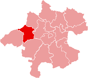
| DescriptionKarte Aut Ooe RI.png | Location of Bezirk Ried im Innkreis within the Land of Upper Austria |
| Date | |
| Source | de:Bild:Karte Aut Ooe RI.png |
| Auteur | de:Benutzer:Plp |
| Autorisation (Réutilisation de ce fichier) |
GFDL-author (licence from German Wikipedia) |
| Autres versions | de:Bild:Karte Aut Ooe RI.png |
Conditions d’utilisation

|
Vous avez la permission de copier, distribuer et modifier ce document selon les termes de la GNU Free Documentation License version 1.2 ou toute version ultérieure publiée par la Free Software Foundation, sans sections inaltérables, sans texte de première page de couverture et sans texte de dernière page de couverture. Un exemplaire de la licence est inclus dans la section intitulée GNU Free Documentation License.http://www.gnu.org/copyleft/fdl.htmlGFDLGNU Free Documentation Licensetruetrue |
| Ce fichier est disponible selon les termes de la licence Creative Commons Attribution – Partage dans les Mêmes Conditions 3.0 (non transposée). | ||
| ||
| Ce bandeau de licence a été ajouté à ce fichier dans le cadre de la procédure de mise à jour des licences des images sous GFDL.http://creativecommons.org/licenses/by-sa/3.0/CC BY-SA 3.0Creative Commons Attribution-Share Alike 3.0truetrue |
Légendes
Ajoutez en une ligne la description de ce que représente ce fichier
Éléments décrits dans ce fichier
dépeint
image/png
Historique du fichier
Cliquer sur une date et heure pour voir le fichier tel qu'il était à ce moment-là.
| Date et heure | Vignette | Dimensions | Utilisateur | Commentaire | |
|---|---|---|---|---|---|
| actuel | 23 juin 2006 à 17:13 | | 300 × 265 (4 kio) | Physchim62 | {{Information |Description=Location of Bezirk Ried im Innkreis within the Land of Upper Austria |Source=de:Bild:Karte Aut Ooe RI.png |Date=2004 |Author=de:Benutzer:Plp |
Utilisation du fichier
Les 38 pages suivantes utilisent ce fichier :
- Andrichsfurt
- Antiesenhofen
- Aurolzmünster
- District de Ried im Innkreis
- Eberschwang
- Eitzing
- Geiersberg
- Geinberg
- Gurten (Autriche)
- Hohenzell
- Kirchdorf am Inn (Autriche)
- Kirchheim im Innkreis
- Lambrechten
- Lohnsburg
- Mehrnbach
- Mettmach
- Mörschwang
- Mühlheim am Inn
- Neuhofen im Innkreis
- Obernberg am Inn
- Ort im Innkreis
- Pattigham
- Peterskirchen
- Pramet
- Reichersberg
- Ried im Innkreis
- Sankt Georgen bei Obernberg am Inn
- Sankt Marienkirchen am Hausruck
- Sankt Martin im Innkreis
- Schildorn
- Senftenbach
- Taiskirchen im Innkreis
- Tumeltsham
- Utzenaich
- Waldzell
- Weilbach (Autriche)
- Wippenham
- Modèle:Palette District de Ried im Innkreis
Usage global du fichier
Les autres wikis suivants utilisent ce fichier :
- Utilisation sur bs.wikipedia.org
- Utilisation sur ce.wikipedia.org
- Орт-им-Иннкрайс
- Кеп:Австри:Рид-им-Иннкрайс гуо:ГІаланаш
- Валдцелл
- Гайерсберг (Оберэстеррайх)
- Айтцинг
- Андриксфурт
- Антизенхофен
- Аурольцмуьнстер
- Вайльбах (Оберэстеррайх)
- Виппенхам
- Гайнберг
- Гуртен
- Зенфтенбах
- Кирхдорф-ам-Инн
- Кирххайм-им-Иннкрайс
- Ламбрехтен
- Лонсбург-ам-Кобернаусервальд
- Мернбах
- Моьршванг
- Меттмах
- Муьльхайм-ам-Инн
- Нойхофен-им-Иннкрайс
- Обернберг-ам-Инн
- Паттигхам
- Петерскирхен
- Прамет
- Райхерсберг
- Рид-им-Иннкрайс
- Санкт-Георген-бай-Обернберг-ам-Инн
- Санкт-Мариенкирхен-ам-Хаусрукк
- Санкт-Мартин-им-Иннкрайс
- Тайскирхен-им-Иннкрайс
- Тумельтсхам
- Утценайх
- Хоэнцелль (Оберэстеррайх)
- Шильдорн
- Эбершванг
- Utilisation sur cs.wikipedia.org
- Utilisation sur de.wikipedia.org
Voir davantage sur l’utilisation globale de ce fichier.
Ce document provient de « https://fr.wikipedia.org/wiki/Fichier:Karte_Aut_Ooe_RI.png ».