Fichier:MSTL_Map.png
De Wikipedia, l'encyclopédie encyclopedia
Taille de cet aperçu : 667 × 600 pixels. Autres résolutions : 267 × 240 pixels | 534 × 480 pixels | 854 × 768 pixels | 1 038 × 933 pixels.
Fichier d’origine (1 038 × 933 pixels, taille du fichier : 275 kio, type MIME : image/png)
Ce fichier et sa description proviennent de Wikimedia Commons.
Description
| DescriptionMSTL Map.png |
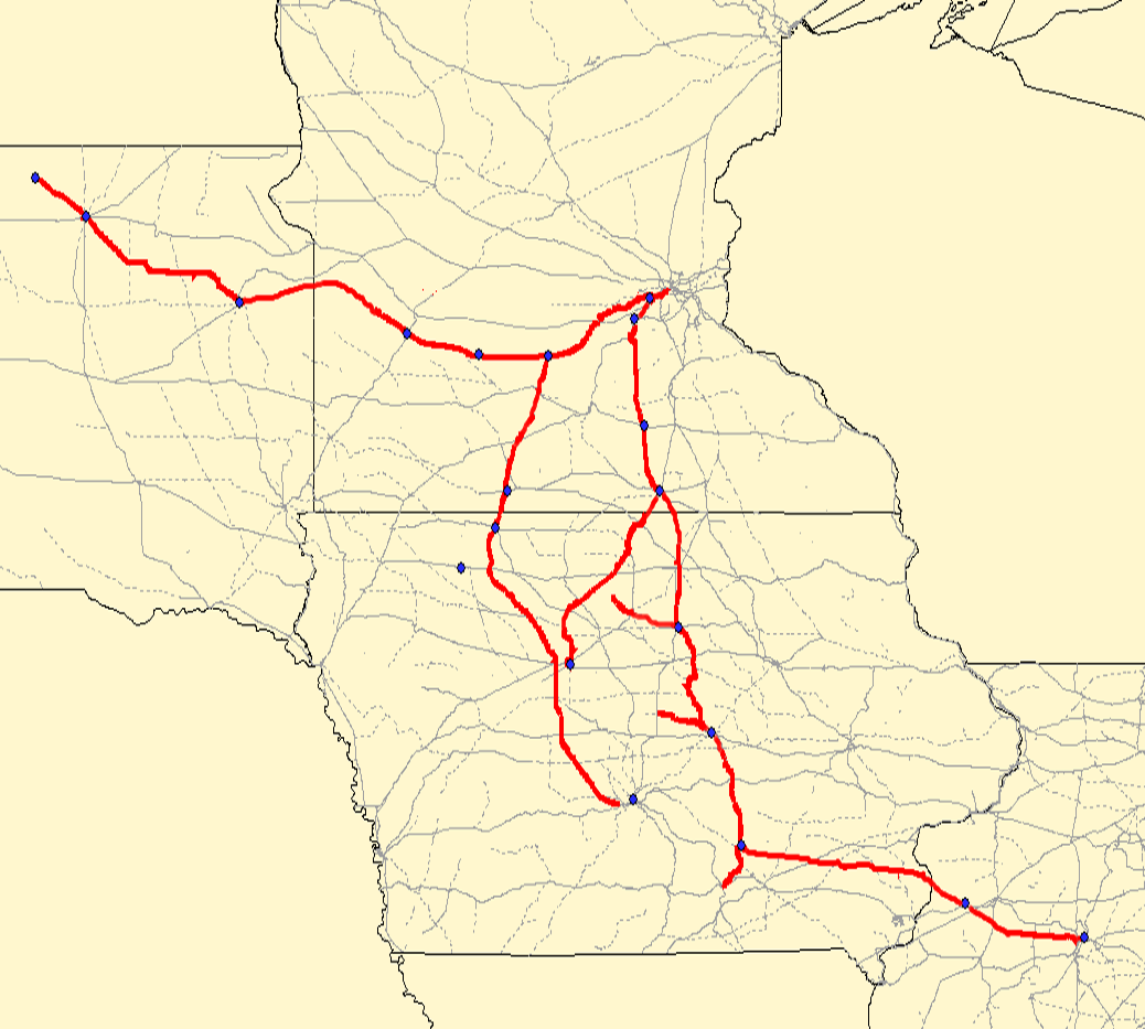
Map of the . Red lines are the MSTL route; gray lines are other railroads. Created using Quantum GIS using data from the Bureau of Transportation Statistics under "Railway Network (1:100,000 base scale)" and queried against the previous railroad of "MSTL". Rechecked against Cash Groth's site and missing/dirty data filled in. |
| Date | 2 septembre 2006 (date de téléversement originale) |
| Source |
Transféré de en.wikipedia à Commons. Cette image matricielle PNG a été créée avec QGIS |
| Auteur | Elkman sur Wikipédia anglais |
Conditions d’utilisation
Ce fichier est sous licence Creative Commons Attribution – Partage dans les Mêmes Conditions 2.5 Générique, 2.0 Générique et 1.0 Générique.
- Vous êtes libre :
- de partager – de copier, distribuer et transmettre cette œuvre
- d’adapter – de modifier cette œuvre
- Sous les conditions suivantes :
- paternité – Vous devez donner les informations appropriées concernant l'auteur, fournir un lien vers la licence et indiquer si des modifications ont été faites. Vous pouvez faire cela par tout moyen raisonnable, mais en aucune façon suggérant que l’auteur vous soutient ou approuve l’utilisation que vous en faites.
- partage à l’identique – Si vous modifiez, transformez, ou vous basez sur cette œuvre, vous devez distribuer votre contribution sous la même licence ou une licence compatible avec celle de l’original.
| Ce fichier est disponible selon les termes de la licence Creative Commons Attribution – Partage dans les Mêmes Conditions 3.0 (non transposée). Sujet aux avertissements. | ||
| ||
| Ce bandeau de licence a été ajouté à ce fichier dans le cadre de la procédure de mise à jour des licences des images sous GFDL.http://creativecommons.org/licenses/by-sa/3.0/CC BY-SA 3.0Creative Commons Attribution-Share Alike 3.0truetrue |

|
Vous avez la permission de copier, distribuer et modifier ce document selon les termes de la GNU Free Documentation License version 1.2 ou toute version ultérieure publiée par la Free Software Foundation, sans sections inaltérables, sans texte de première page de couverture et sans texte de dernière page de couverture. Un exemplaire de la licence est inclus dans la section intitulée GNU Free Documentation License. Sujet aux avertissements.http://www.gnu.org/copyleft/fdl.htmlGFDLGNU Free Documentation Licensetruetrue |
Moi, en tant que détenteur des droits d’auteur sur cette œuvre, je la publie sous la licence suivante :
Moi, en tant que détenteur des droits d’auteur sur cette œuvre, je la publie sous la licence suivante :
Journal des téléversements d’origine
La page de description originale était ici. Tous les noms d'utilisateur qui suivent se rapportent à en.wikipedia.
- 2006-09-02 04:35 Elkman 1038×933×8 (281134 bytes) Map of the [[Minneapolis and St. Louis Railway]]. Red lines are the MSTL route; gray lines are other railroads. Created using Quantum GIS using data from [http://www.bts.gov/publications/national_transportation_atlas_database/2006/ the Bureau of Transpo
Légendes
Ajoutez en une ligne la description de ce que représente ce fichier
Éléments décrits dans ce fichier
dépeint
2 septembre 2006
Historique du fichier
Cliquer sur une date et heure pour voir le fichier tel qu'il était à ce moment-là.
| Date et heure | Vignette | Dimensions | Utilisateur | Commentaire | |
|---|---|---|---|---|---|
| actuel | 24 juin 2007 à 18:25 | | 1 038 × 933 (275 kio) | SieBot | {{Information |Description=Map of the en:Minneapolis and St. Louis Railway. Red lines are the MSTL route; gray lines are other railroads. Created using Quantum GIS using data from [http://www.bts.gov/publications/national_transportation_atlas_data |
Utilisation du fichier
La page suivante utilise ce fichier :
Usage global du fichier
Les autres wikis suivants utilisent ce fichier :
- Utilisation sur en.wikipedia.org
- Utilisation sur it.wikipedia.org
- Utilisation sur ro.wikipedia.org
- Berwick, Iowa
- Des Moines, Iowa
- Categorie:Statul Iowa, SUA
- Iowa
- Iowa (dezambiguizare)
- Format:Iowa stat SUA
- Categorie:Formate Iowa
- Categorie:Liste Iowa
- Categorie:Comitate din statul Iowa, SUA
- Buffalo, Iowa
- Listă de oameni din statul Iowa
- Categorie:Guvernul statului Iowa
- Listă de comitate din statul Iowa
- Categorie:Sedii de comitate din Iowa
- Categorie:Comitatul Washington, Iowa
- Listă de orașe din statul Iowa
- Categorie:Comitatul Adams, Iowa
- Comitatul Adams, Iowa
- Categorie:Comitatul Adair, Iowa
- Categorie:Comitatul Allamakee, Iowa
- Categorie:Comitatul Appanoose, Iowa
- Categorie:Comitatul Audubon, Iowa
- Categorie:Comitatul Benton, Iowa
- Categorie:Comitatul Black Hawk, Iowa
- Categorie:Comitatul Boone, Iowa
- Categorie:Comitatul Bremer, Iowa
- Categorie:Comitatul Buchanan, Iowa
- Categorie:Comitatul Buena Vista, Iowa
- Categorie:Comitatul Cedar, Iowa
- Categorie:Comitatul Cerro Gordo, Iowa
- Categorie:Comitatul Cherokee, Iowa
- Categorie:Comitatul Chickasaw, Iowa
- Categorie:Comitatul Clarke, Iowa
- Categorie:Comitatul Clay, Iowa
- Categorie:Comitatul Clinton, Iowa
- Categorie:Comitatul Crawford, Iowa
- Categorie:Comitatul Davis, Iowa
- Categorie:Comitatul Decatur, Iowa
- Categorie:Comitatul Delaware, Iowa
- Categorie:Comitatul Des Moines, Iowa
- Categorie:Comitatul Polk, Iowa
- Categorie:Comitatul Dickinson, Iowa
- Manchester, Iowa
- Categorie:Comitatul Dubuque, Iowa
- Categorie:Comitatul Emmet, Iowa
- Categorie:Comitatul Fayette, Iowa
- Categorie:Comitatul Floyd, Iowa
- Categorie:Comitatul Franklin, Iowa
Voir davantage sur l’utilisation globale de ce fichier.
Ce document provient de « https://fr.wikipedia.org/wiki/Fichier:MSTL_Map.png ».