Fichier:Nargis_2008_track.png
De Wikipedia, l'encyclopédie encyclopedia
Taille de cet aperçu : 800 × 495 pixels. Autres résolutions : 320 × 198 pixels | 640 × 396 pixels | 1 024 × 633 pixels | 1 280 × 791 pixels | 2 700 × 1 669 pixels.
Fichier d’origine (2 700 × 1 669 pixels, taille du fichier : 4,64 Mio, type MIME : image/png)
Ce fichier et sa description proviennent de Wikimedia Commons.
Description
| DescriptionNargis 2008 track.png |
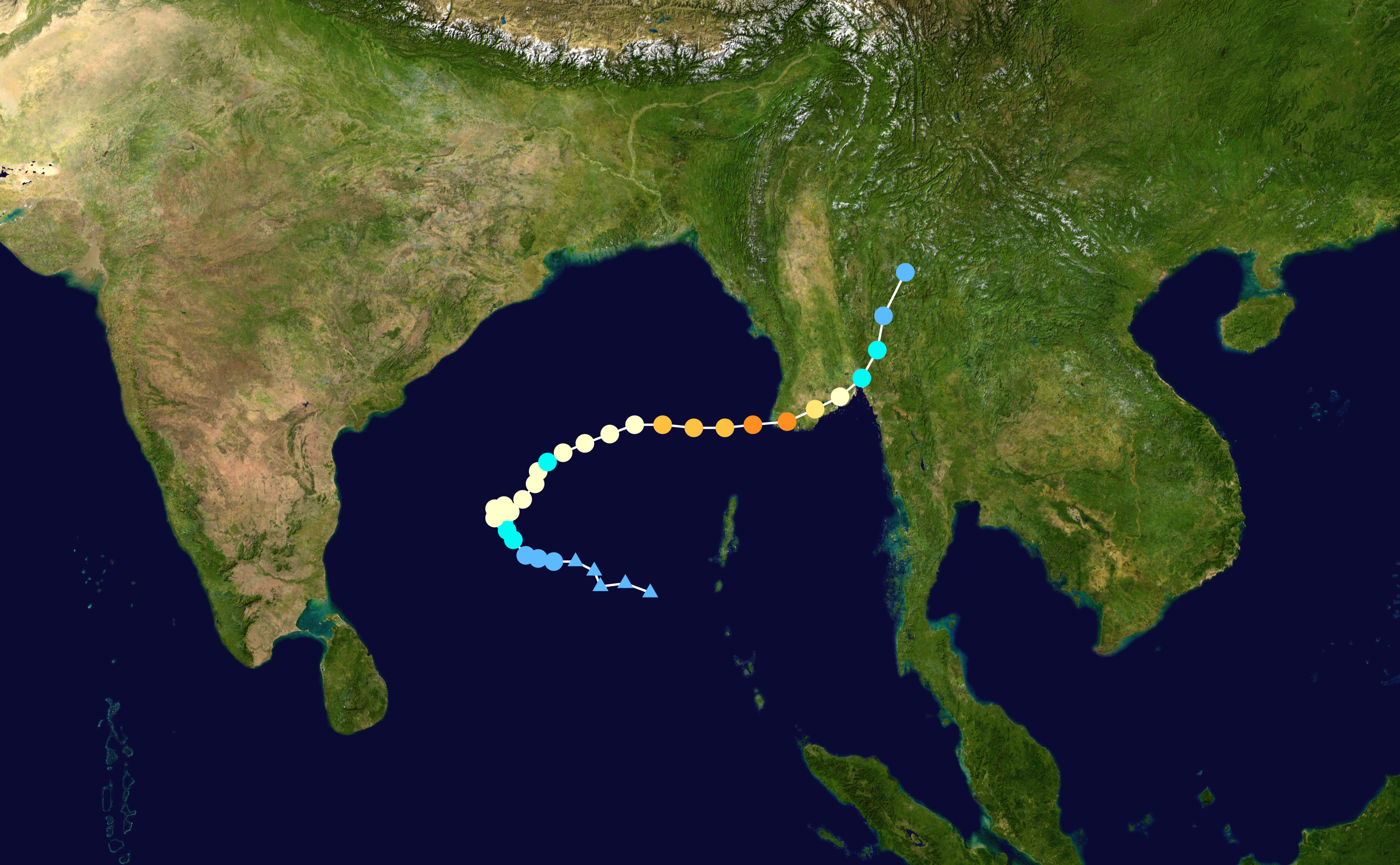
English: Track map of Extremely Severe Cyclonic Storm Nargis of the 2008 North Indian Ocean cyclone season. The points show the location of the storm at 6-hour intervals. The colour represents the storm's maximum sustained wind speeds as classified in the (see below), and the shape of the data points represent the nature of the storm, according to the legend below. Storm type |
||
| Date | 2008-04-25–2008-05-04 | ||
| Source | Created by Ramisses using Wikipedia:WikiProject Tropical cyclones/Tracks. The background image is from NASA. Tracking data is from the Joint Typhoon Warning Center[1]. | ||
| Auteur | Ramisses | ||
| Source code InfoField | Track map data table, if present below, is in HURDAT2 or ATCF format. See format details in [2] and [3], respectively.
|
Conditions d’utilisation
| Public domainPublic domainfalsefalse |
| Cette œuvre a été placée dans le domaine public par son auteur, Ramisses. Ceci s’applique dans le monde entier. Dans certains pays, ceci peut ne pas être possible ; dans ce cas : Ramisses accorde à toute personne le droit d’utiliser cette œuvre dans n’importe quel but, sans aucune condition, sauf celles requises par la loi. |
Légendes
Ajoutez en une ligne la description de ce que représente ce fichier
Éléments décrits dans ce fichier
dépeint
image/png
Historique du fichier
Cliquer sur une date et heure pour voir le fichier tel qu'il était à ce moment-là.
| Date et heure | Vignette | Dimensions | Utilisateur | Commentaire | |
|---|---|---|---|---|---|
| actuel | 18 juillet 2020 à 05:13 | | 2 700 × 1 669 (4,64 Mio) | Supportstorm | 2700 px |
| 19 mai 2013 à 17:12 |  | 2 000 × 1 236 (2,25 Mio) | Cyclonebiskit | higher resolution | |
| 31 mars 2009 à 21:17 |  | 1 024 × 633 (820 kio) | Potapych | Best track update | |
| 30 mai 2008 à 16:33 |  | 1 024 × 633 (770 kio) | Nilfanion | Cleaner track (anti-aliasing) | |
| 30 mai 2008 à 01:44 |  | 1 024 × 633 (766 kio) | Nilfanion | WPTC track | |
| 7 mai 2008 à 05:04 |  | 1 024 × 636 (24 kio) | Ramisses | == Summary == Cyclone Jokwe track map. Tracking data from [https://metocph.nmci.navy.mil/jtwc.php JTWC] '''Alert''', This track map should be replaced by a WikiProject Tropical cyclones track map when is available. {{Information |Description=Cyclone Nar |
Utilisation du fichier
La page suivante utilise ce fichier :
Usage global du fichier
Les autres wikis suivants utilisent ce fichier :
- Utilisation sur ar.wikipedia.org
- Utilisation sur ca.wikipedia.org
- Utilisation sur cs.wikipedia.org
- Utilisation sur da.wikipedia.org
- Utilisation sur de.wikipedia.org
- Utilisation sur en.wikipedia.org
- Utilisation sur fi.wikipedia.org
- Utilisation sur he.wikipedia.org
- Utilisation sur id.wikipedia.org
- Utilisation sur ja.wikipedia.org
- Utilisation sur ko.wikipedia.org
- Utilisation sur lv.wikipedia.org
- Utilisation sur ml.wikipedia.org
- Utilisation sur my.wikipedia.org
- Utilisation sur nl.wikipedia.org
- Utilisation sur no.wikipedia.org
- Utilisation sur pl.wikipedia.org
- Utilisation sur pt.wikipedia.org
- Utilisation sur ro.wikipedia.org
- Utilisation sur sco.wikipedia.org
- Utilisation sur sk.wikipedia.org
- Utilisation sur sv.wikipedia.org
- Utilisation sur th.wikipedia.org
- Utilisation sur vi.wikipedia.org
- Utilisation sur zh.wikipedia.org
Ce document provient de « https://fr.wikipedia.org/wiki/Fichier:Nargis_2008_track.png ».