Fichier:Philippines_Wind_Power_Density_Map.jpg
De Wikipedia, l'encyclopédie encyclopedia
Taille de cet aperçu : 800 × 568 pixels. Autres résolutions : 320 × 227 pixels | 640 × 454 pixels | 1 024 × 726 pixels | 1 280 × 908 pixels | 2 712 × 1 924 pixels.
Fichier d’origine (2 712 × 1 924 pixels, taille du fichier : 308 kio, type MIME : image/jpeg)
Ce fichier et sa description proviennent de Wikimedia Commons.
Description
| DescriptionPhilippines Wind Power Density Map.jpg |
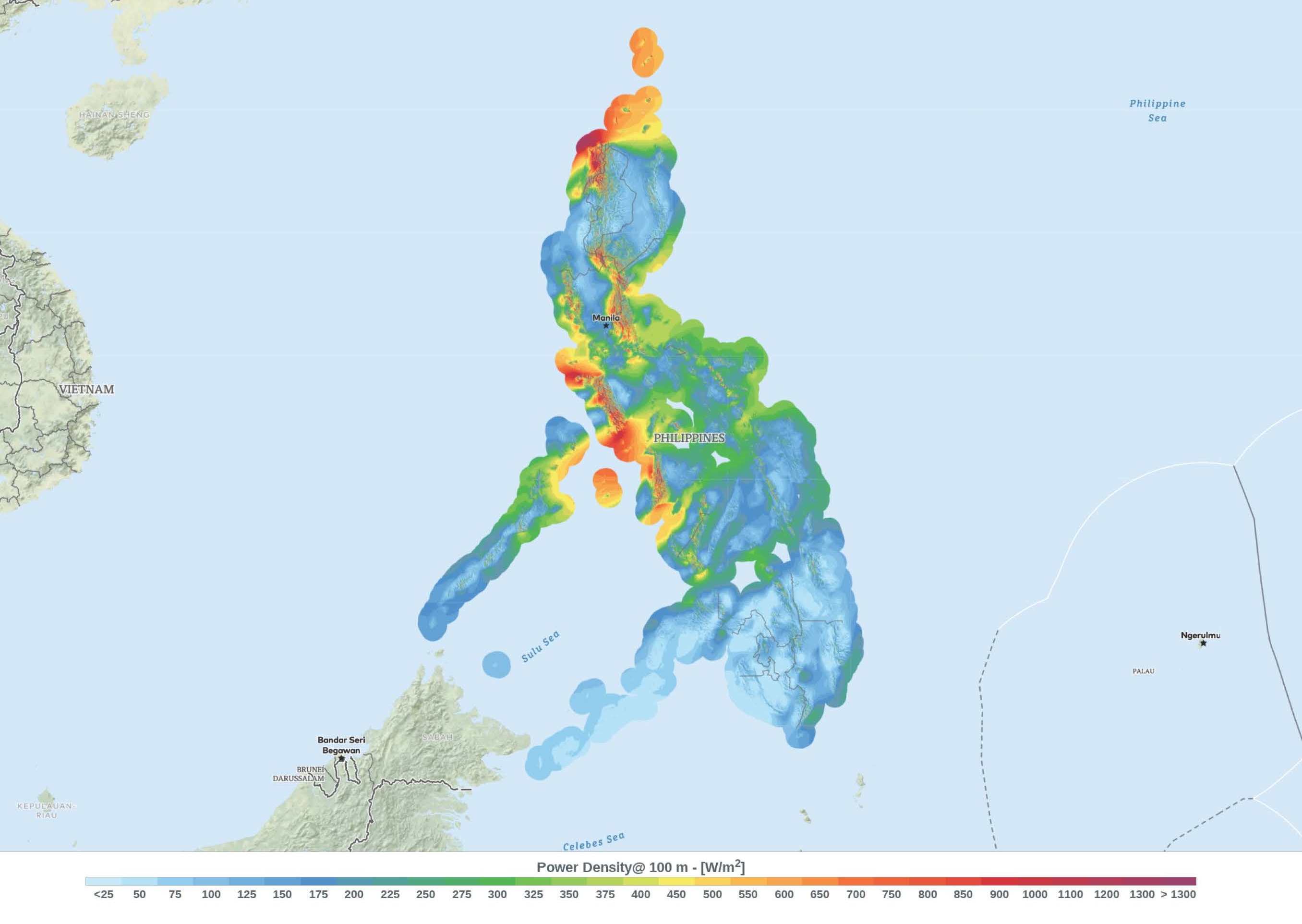
English: This wind resource map provides an estimated summary of mean wind power density at 100 m above surface level. Power density indicates wind power potential, part of which can be extracted by wind turbines. The map is derived from high-resolution wind speed distributions based on a chain of models, which downscales winds from global models (~70 km), to mesoscale (9 km) to microscale (150 m terrain). The resulting resolution is 250 m. |
| Date | |
| Source | https://globalwindatlas.info/ |
| Auteur | Technical University of Denmark |
The map is downloaded form the Global Wind Atlas (version 2.2), a free, web-based application developed, owned and operated by the Technical University of Denmark (DTU) in partnership with the World Bank Group, utilizing data provided by Vortex, with funding provided by the Energy Sector Management Assistance Program (ESMAP). For additional information: https://globalwindatlas.info
Conditions d’utilisation
Ce fichier est disponible selon les termes de la licence Creative Commons Attribution 4.0 International.
- Vous êtes libre :
- de partager – de copier, distribuer et transmettre cette œuvre
- d’adapter – de modifier cette œuvre
- Sous les conditions suivantes :
- paternité – Vous devez donner les informations appropriées concernant l'auteur, fournir un lien vers la licence et indiquer si des modifications ont été faites. Vous pouvez faire cela par tout moyen raisonnable, mais en aucune façon suggérant que l’auteur vous soutient ou approuve l’utilisation que vous en faites.
Légendes
Ajoutez en une ligne la description de ce que représente ce fichier
Éléments décrits dans ce fichier
dépeint
19 septembre 2018
image/jpeg
Historique du fichier
Cliquer sur une date et heure pour voir le fichier tel qu'il était à ce moment-là.
| Date et heure | Vignette | Dimensions | Utilisateur | Commentaire | |
|---|---|---|---|---|---|
| actuel | 5 mars 2020 à 22:55 | | 2 712 × 1 924 (308 kio) | Doc James | Cropped 20 % horizontally, 20 % vertically using CropTool with precise mode. |
| 25 septembre 2018 à 09:52 |  | 3 390 × 2 398 (305 kio) | O-Jay | User created page with UploadWizard |
Utilisation du fichier
La page suivante utilise ce fichier :
Usage global du fichier
Les autres wikis suivants utilisent ce fichier :
- Utilisation sur en.wikipedia.org
- Utilisation sur tr.wikipedia.org
- Utilisation sur uk.wikipedia.org
- Utilisation sur uz.wikipedia.org
- Utilisation sur www.wikidata.org
Ce document provient de « https://fr.wikipedia.org/wiki/Fichier:Philippines_Wind_Power_Density_Map.jpg ».