Fichier:Relief_map_of_USA_Michigan.png
De Wikipedia, l'encyclopédie encyclopedia
Fichier d’origine (1 066 × 1 200 pixels, taille du fichier : 1 000 kio, type MIME : image/png)
Ce fichier et sa description proviennent de Wikimedia Commons.
Description
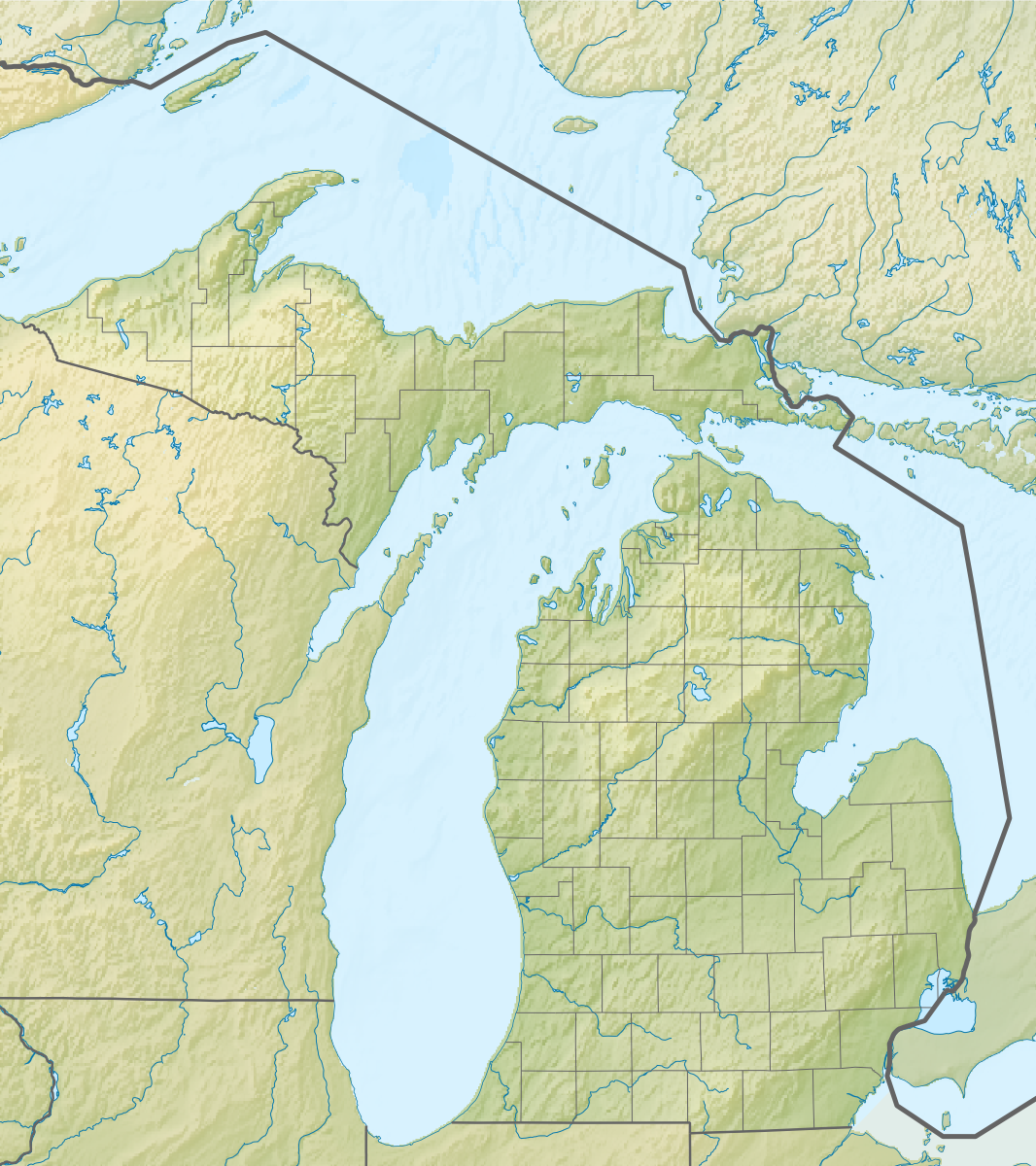
| DescriptionRelief map of USA Michigan.png |
Русский: Физическая карта штата Мичиган (США).
Equirectangular projection, N/S stretching 140.0 %. Geographic limits of the map:
|
| Date | |
| Source |
Cette PNG image matricielle a été créée avec Inkscape . |
| Auteur | Nzeemin |
| Autres versions |
|

Conditions d’utilisation
- Vous êtes libre :
- de partager – de copier, distribuer et transmettre cette œuvre
- d’adapter – de modifier cette œuvre
- Sous les conditions suivantes :
- paternité – Vous devez donner les informations appropriées concernant l'auteur, fournir un lien vers la licence et indiquer si des modifications ont été faites. Vous pouvez faire cela par tout moyen raisonnable, mais en aucune façon suggérant que l’auteur vous soutient ou approuve l’utilisation que vous en faites.
- partage à l’identique – Si vous modifiez, transformez, ou vous basez sur cette œuvre, vous devez distribuer votre contribution sous la même licence ou une licence compatible avec celle de l’original.
Légendes
Éléments décrits dans ce fichier
dépeint
Valeur sans élément de Wikidata
22 novembre 2012
Historique du fichier
Cliquer sur une date et heure pour voir le fichier tel qu'il était à ce moment-là.
| Date et heure | Vignette | Dimensions | Utilisateur | Commentaire | |
|---|---|---|---|---|---|
| actuel | 22 novembre 2012 à 11:42 | | 1 066 × 1 200 (1 000 kio) | Nzeemin | User created page with UploadWizard |
Utilisation du fichier
Plus de 100 pages utilisent ce fichier. La liste suivante affiche seulement les 100 premières pages qui utilisent ce fichier. Une liste complète est disponible.
- Akron (Michigan)
- Allegan
- Battle Creek (Michigan)
- Belle Isle (parc)
- Berkley (Michigan)
- Berlin Charter Township
- Berrien Springs
- Beulah (Michigan)
- Birmingham (Michigan)
- Bloomfield Hills
- Bloomfield Township (comté d'Oakland, Michigan)
- Bridgeport (Michigan)
- Cadillac (Michigan)
- Caro (Michigan)
- Centreville (Michigan)
- Charlotte (Michigan)
- Chesaning
- Clawson (Michigan)
- Clinton Charter Township
- Coldwater (Michigan)
- Crystal Falls (Michigan)
- Detroit Beach (Michigan)
- Devil's Kitchen
- Détroit (Michigan)
- Détroit de Mackinac
- Eaton Rapids
- Escanaba
- Farmington Hills
- Ferndale (Michigan)
- Flint (Michigan)
- Frenchtown (Michigan)
- Gaylord (Michigan)
- Gladwin (Michigan)
- Grand Blanc (Michigan)
- Grand Haven
- Grand Marais (Michigan)
- Grand Rapids (Michigan)
- Harrison (Michigan)
- Harrison Township (Michigan)
- Hart (Michigan)
- Hastings (Michigan)
- Hazel Park (Michigan)
- Hillsdale (Michigan)
- Holland (Michigan)
- Houghton (Michigan)
- Huntington Woods
- Iron Mountain (Michigan)
- Ishpeming
- Kalkaska
- L'Anse (Michigan)
- L'Anse Township (Michigan)
- Lac Sainte-Claire
- Lake City (Michigan)
- Ludington (Michigan)
- Macomb Township (Michigan)
- Madison Heights (Michigan)
- Manistique
- Marshall (Michigan)
- Mason (Michigan)
- Menominee (Michigan)
- Michigan International Speedway
- Midland (Michigan)
- Monroe (Michigan)
- Mont Arvon
- Mont Curwood
- Mount Pleasant (Michigan)
- Munising
- Muskegon Heights
- Norton Shores
- Novi (Michigan)
- Oak Park (Michigan)
- Ontonagon
- Owosso
- Paw Paw (Michigan)
- Pleasant Ridge (Michigan)
- Port Huron
- Presque Isle (Michigan)
- Reed City
- Richmond (Michigan)
- Rochester (Michigan)
- Rochester Hills
- Rogers City
- Roscommon (Michigan)
- Roseville (Michigan)
- Royal Oak (Michigan)
- Royal Oak Charter Township
- Saint-Ignace (Michigan)
- Saint-Joseph (Michigan)
- Saint Clair Shores
- Sault Sainte-Marie (Michigan)
- Skull Cave (Michigan)
- Southfield (Michigan)
- St. Johns (Michigan)
- Standish (Michigan)
- Stanton (Michigan)
- Suttons Bay Township
- Troy (Michigan)
- West Bloomfield Township
- West Branch (Michigan)
- White Cloud (Michigan)
Voir plus de liens vers ce fichier.
Usage global du fichier
Les autres wikis suivants utilisent ce fichier :
- Utilisation sur ar.wikipedia.org
- Utilisation sur az.wikipedia.org
- Utilisation sur ba.wikipedia.org
- Utilisation sur bn.wikipedia.org
- Utilisation sur ca.wikipedia.org
- Utilisation sur ceb.wikipedia.org
- Utilisation sur ce.wikipedia.org
- Utilisation sur cs.wikipedia.org
- Utilisation sur de.wikipedia.org
- Michigansee
- WEYI-Sendemast
- Isle Royale
- Old Mission Peninsula
- Belle Isle (Detroit)
- Belle Isle (Isle Royale National Park)
- Mackinac Island
- Vorlage:Positionskarte USA Michigan
- Indian Lake State Park (Michigan)
- Alexander Lake (Michigan)
- Warren Dunes State Park
- Hubbard Lake (Michigan)
- Grassy Island (Michigan)
- Beaver Island (Charlevoix County, Michigan)
- Pumpspeicherkraftwerk Ludington
- Round Island (Mackinac County)
- Mount Arvon
- Pogy Lake
- Stony Island (Wayne County, Michigan)
- Drummond Island
- WGRT
- Bois Blanc Island (Huronsee)
- WILS
- North Manitou Island
- South Manitou Island
- WCMU-FM
- Grand Island (Alger County, Michigan)
- Suttons Bay (Bucht)
- Otsego Lake (Michigan)
- Utilisation sur de.wikivoyage.org
- Utilisation sur el.wikipedia.org
- Utilisation sur en.wikipedia.org
Voir davantage sur l’utilisation globale de ce fichier.
Métadonnées
Ce fichier contient des informations supplémentaires, probablement ajoutées par l'appareil photo numérique ou le numériseur utilisé pour le créer.
Si le fichier a été modifié depuis son état original, certains détails peuvent ne pas refléter entièrement l'image modifiée.
| Résolution horizontale | 35,43 pt/cm |
|---|---|
| Résolution verticale | 35,43 pt/cm |
| Logiciel utilisé |
|