File:Map_Greece_expansion_1832-1947-nl.svg
De Wikipedia, l'encyclopédie encyclopedia

Taille de cet aperçu PNG pour ce fichier SVG : 457 × 599 pixels. Autres résolutions : 183 × 240 pixels | 366 × 480 pixels | 586 × 768 pixels | 781 × 1 024 pixels | 1 562 × 2 048 pixels | 734 × 962 pixels.
Fichier d’origine (Fichier SVG, nominalement de 734 × 962 pixels, taille : 56 kio)
Ce fichier et sa description proviennent de Wikimedia Commons.
| DescriptionMap Greece expansion 1832-1947-nl.svg |
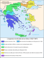
Čeština: Mapa zobrazuje územní expanzi Řeckého království (1832–1947). Dansk: Kort over Grækenlands territoriale udvidelser, 1832-1947. Deutsch: Territoriale Expansion Griechenlands 1832-1947. English: The territorial expansion of Greece, 1832-1947. Español: Mapa de la expansión territorial griega (1832-1947) Euskara: Greziaren lurralde hedapena 1832-1947 bitartean Français : L'expansion territoriale de la Grèce. 1832-1947. Hrvatski: Teritorijalno proširenje Grčke u razdoblju od 1832. do 1947. Italiano: L'espansione territoriale della Grecia dal 1832 al 1947 Magyar: Görögország területi növekedése (1832-1947) Occitan : Evolucions territòrialas de Grècia. Ελληνικά: Η εδαφική επέκταση της Ελλάδας 1832-1947. Македонски: Територијално проширување на Грција Українська: Територіальна експансія Греції (1832-1947). 日本語: ギリシャ王国の版図拡大 (1832-1947年) 中文: 希腊的领土变迁,1832年-1947年间。 العربية : خريطة تُصوِّر الأراضي التي استولت عليها اليونان مُنذُ سنة 1832م حين استقلالها عن الدولة العُثمانيَّة، وُصولًا إلى سنة 1947م |
||||||||
| Date | |||||||||
| Source | Image:Map Greece expansion 1832-1947-fr.svg (adaptation of Image:Population exchange 1923.gif, GFDL). Image renamed from Image:L'expansion territoriale de la Grèce 1832-1947.svg | ||||||||
| Auteur | Historicair, translator Rursus | ||||||||
| Autorisation (Réutilisation de ce fichier) |
|
||||||||
| Autres versions |
[modifier]
|


.PNG)


.png)


Légendes
Ajoutez en une ligne la description de ce que représente ce fichier
Éléments décrits dans ce fichier
dépeint
31 mars 2007
Historique du fichier
Cliquer sur une date et heure pour voir le fichier tel qu'il était à ce moment-là.
| Date et heure | Vignette | Dimensions | Utilisateur | Commentaire | |
|---|---|---|---|---|---|
| actuel | 25 février 2012 à 11:34 | | 734 × 962 (56 kio) | Brbbl | Added first Capital Nafplio, changed border colors to grey so that citynames are more readable, rearrenged legenda, added present names of certain cities and Island. |
| 24 février 2012 à 20:11 |  | 734 × 962 (55 kio) | Brbbl | replaced Oost-Thracië in West-Thracië in legenda | |
| 15 février 2008 à 13:36 |  | 734 × 962 (111 kio) | Evil berry | ||
| 15 février 2008 à 13:34 |  | 734 × 962 (110 kio) | Evil berry | {{Information |Description= {{en|The territorial expansion of Greece, 1832-1947 (Dutch translation, added colors of WikiProject Maps).}} |Source=Image:Map Greece expansion 1832-1947-fr.svg (adaptation o |
Utilisation du fichier
Aucune page n’utilise ce fichier.
Usage global du fichier
Les autres wikis suivants utilisent ce fichier :
- Utilisation sur nl.wikipedia.org
- Utilisation sur nl.wiktionary.org
Ce document provient de « https://fr.wikipedia.org/wiki/Fichier:Map_Greece_expansion_1832-1947-nl.svg ».