File:WW2-Holocaust-Ukraine_big_legend.PNG
De Wikipedia, l'encyclopédie encyclopedia
WW2-Holocaust-Ukraine_big_legend.PNG (700 × 342 pixels, taille du fichier : 237 kio, type MIME : image/png)
Ce fichier et sa description proviennent de Wikimedia Commons.
Sommaire
Description
| DescriptionWW2-Holocaust-Ukraine big legend.PNG |
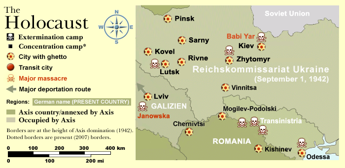
Map of the Holocaust in Ukraine during World War II, 1939-1945. This map shows all extermination camps (or death camps), most major concentration camps, labor camps, prison camps, ghettos, major deportation routes and major massacre sites. Notes: 1. Extermination camps were dedicated death camps, but all camps and ghettos took a toll of many, many lives. 2. Concentration camps include labor camps, prison camps & transit camps. 3. Not all camps & ghettos are shown. 4. Borders are at the height of Axis domination (1942). 5. Some regions have German designations (e.g. "Ostland"), with the present country name denoted in uppercase letters in parenthesis below the German designation (e.g. "(AUSTRIA)"). 6. Present (2007) borders are dotted. Map of the Holocaust in Europe during World War II, 1939-1945. This map shows all extermination camps (or death camps), most major concentration camps, labor camps, prison camps, ghettos, major deportation routes and major massacre sites. Notes: 1. Extermination camps were dedicated death camps, but all camps and ghettos took a toll of many, many lives. 2. Concentration camps include labor camps, prison camps & transit camps. 3. Not all camps & ghettos are shown. 4. Borders are at the height of Axis domination (1942). 5. Some regions have German designations (e.g. "Ostland"), with the present country name denoted in uppercase letters in parenthesis below the German designation (e.g. "(AUSTRIA)"). 6. Present (2007) borders are dotted. |
| Date | (UTC) |
| Source | |
| Auteur | |
| Autorisation (Réutilisation de ce fichier) |
CC, see below. The map is completely unrestricted for any Wikipedia/Wikimedia project. |
| Autres versions | Œuvres dérivées de ce fichier : WW2-Holocaust-Poland.PNGImage:WW2-Holocaust-Europe-2007Borders.png (present (2007) borders). If you have any opinions/suggestions, please contact me here on my talk page. |

|
Cette image (de type historical map) devrait être recréée dans un format vectoriel, en tant que fichier SVG. Cela offrirait plusieurs avantages : voir Commons:Media for cleanup pour plus d'informations. Si une version SVG de cette image est déjà disponible, merci de bien vouloir l'envoyer. Après cela, remplacez ce modèle par {{vector version available|nouveau nom d'image.svg}}.
|
Conditions d’utilisation
- Vous êtes libre :
- de partager – de copier, distribuer et transmettre cette œuvre
- d’adapter – de modifier cette œuvre
- Sous les conditions suivantes :
- paternité – Vous devez donner les informations appropriées concernant l'auteur, fournir un lien vers la licence et indiquer si des modifications ont été faites. Vous pouvez faire cela par tout moyen raisonnable, mais en aucune façon suggérant que l’auteur vous soutient ou approuve l’utilisation que vous en faites.
: *WW2-Holocaust-Europe.png: User:Dna-Dennis
|Permission=CC, see below. The map is completely unrestricted for any Wikipedia/Wikimedia project. |other_versions=Œuvres dérivées de ce fichier : WW2-Holocaust-Poland.PNGImage:WW2-Holocaust-Europe-2007Borders.png (present (2007) borders). If you have any opinions/suggestions, please contact me here on my talk page. }}
- derivative work: Piotr Konieczny aka Prokonsul Piotrus Talk
|Permission= |other_versions= }}
| Cette image a été retouchée, ce qui signifie qu'elle a été modifiée par ordinateur et est différente de l'image d'origine. Liste des modifications : Smaller version: occupied Ukraine only. L'image d'origine se trouve ici : WW2-Holocaust-Europe.png:
|
Journal des téléversements d’origine
This image is a derivative work of the following images:
- File:WW2-Holocaust-Europe.png licensed with Cc-by-3.0
- 2007-12-20T03:41:38Z Dna-webmaster 1310x1090 (845818 Bytes) new version without "Axis cooperating" in legend
- 2007-12-20T02:00:30Z Dna-webmaster 1310x1090 (844034 Bytes) Now entire West Prussia and Wartheland is included in the Third Reich
- 2007-12-19T16:42:15Z Dna-webmaster 1310x1090 (847461 Bytes) still not Da Vinci, but errors have been corrected (Germany borders West/East), West & East Prussia borders/coloring and Poland General Government corrected borders.
- 2007-12-17T10:46:28Z Dna-webmaster 1310x1090 (844633 Bytes) new map with 1942 borders, not Da Vinci, but here it goes...
- 2007-10-19T13:32:25Z Dna-webmaster 1310x1090 (784727 Bytes) and another update
- 2007-10-19T12:21:52Z Dna-webmaster 1310x1090 (789383 Bytes) quick fix
- 2007-10-19T12:11:07Z Dna-webmaster 1310x1090 (789413 Bytes) {{Information |Description=Map of the Holocaust in Europe during World War II, 1939-1945. This map shows all extermination camps (or ''death camps''), most major concentration camps, work camps, prison camps, ghettos, major
Téléversé avec derivativeFX
[[Catego
- derivative work: Piotr Konieczny aka Prokonsul Piotrus Talk
|Permission= |other_versions= }}
| Cette image a été retouchée, ce qui signifie qu'elle a été modifiée par ordinateur et est différente de l'image d'origine. Liste des modifications : legend from primary map. L'image d'origine se trouve ici : WW2-Holocaust-Ukraine.PNG:
|
- Vous êtes libre :
- de partager – de copier, distribuer et transmettre cette œuvre
- d’adapter – de modifier cette œuvre
- Sous les conditions suivantes :
- paternité – Vous devez donner les informations appropriées concernant l'auteur, fournir un lien vers la licence et indiquer si des modifications ont été faites. Vous pouvez faire cela par tout moyen raisonnable, mais en aucune façon suggérant que l’auteur vous soutient ou approuve l’utilisation que vous en faites.
Journal des téléversements d’origine
This image is a derivative work of the following images:
- File:WW2-Holocaust-Europe.png licensed with Cc-by-3.0
- 2007-12-20T03:41:38Z Dna-webmaster 1310x1090 (845818 Bytes) new version without "Axis cooperating" in legend
- 2007-12-20T02:00:30Z Dna-webmaster 1310x1090 (844034 Bytes) Now entire West Prussia and Wartheland is included in the Third Reich
- 2007-12-19T16:42:15Z Dna-webmaster 1310x1090 (847461 Bytes) still not Da Vinci, but errors have been corrected (Germany borders West/East), West & East Prussia borders/coloring and Poland General Government corrected borders.
- 2007-12-17T10:46:28Z Dna-webmaster 1310x1090 (844633 Bytes) new map with 1942 borders, not Da Vinci, but here it goes...
- 2007-10-19T13:32:25Z Dna-webmaster 1310x1090 (784727 Bytes) and another update
- 2007-10-19T12:21:52Z Dna-webmaster 1310x1090 (789383 Bytes) quick fix
- 2007-10-19T12:11:07Z Dna-webmaster 1310x1090 (789413 Bytes) {{Information |Description=Map of the Holocaust in Europe during World War II, 1939-1945. This map shows all extermination camps (or ''death camps''), most major concentration camps, work camps, prison camps, ghettos, major
- File:WW2-Holocaust-Ukraine.PNG licensed with Cc-by-3.0
- 2009-02-19T18:43:50Z Piotrus 376x240 (54085 Bytes) {{Information |Description=Map of the Holocaust in Europe during World War II, 1939-1945. This map shows all extermination camps (or ''death camps''), most major concentration camps, labor camps, prison camps, ghettos, major
Téléversé avec derivativeFX
[[Category:Ghettos in occup
Légendes
Éléments décrits dans ce fichier
dépeint
19 février 2009
image/png
Historique du fichier
Cliquer sur une date et heure pour voir le fichier tel qu'il était à ce moment-là.
| Date et heure | Vignette | Dimensions | Utilisateur | Commentaire | |
|---|---|---|---|---|---|
| actuel | 24 juillet 2015 à 11:07 | | 700 × 342 (237 kio) | Poeticbent | overhaul, cities added, map area enlarged, borders redefined from official records |
| 4 mai 2013 à 23:22 |  | 700 × 371 (118 kio) | Poeticbent | r/m dead space, incl. left-over legend from a different map, i.e. Italy, added July 1941 | |
| 19 février 2009 à 20:47 |  | 700 × 393 (87 kio) | Piotrus | {{Information |Description=Map of the Holocaust in Europe during World War II, 1939-1945. <br> This map shows all extermination camps (or ''death camps''), most major concentration camps, labor camps, prison camps, ghettos, major deportation routes and ma |
Utilisation du fichier
Les 2 pages suivantes utilisent ce fichier :
Usage global du fichier
Les autres wikis suivants utilisent ce fichier :
- Utilisation sur da.wikipedia.org
- Utilisation sur de.wikipedia.org
- Utilisation sur en.wikipedia.org
- Utilisation sur es.wikipedia.org
- Utilisation sur he.wikipedia.org
- Utilisation sur it.wikipedia.org
- Utilisation sur ko.wikipedia.org
- Utilisation sur pl.wikipedia.org
- Utilisation sur pt.wikipedia.org
- Utilisation sur ru.wikipedia.org
- Utilisation sur th.wikipedia.org
- Utilisation sur tr.wikipedia.org
- Utilisation sur uk.wikipedia.org
- Utilisation sur vi.wikipedia.org
- Utilisation sur zh.wikipedia.org
Métadonnées
Ce fichier contient des informations supplémentaires, probablement ajoutées par l'appareil photo numérique ou le numériseur utilisé pour le créer.
Si le fichier a été modifié depuis son état original, certains détails peuvent ne pas refléter entièrement l'image modifiée.
| Logiciel utilisé |
|
|---|