Ofbyld:Benuerivermap.png
From Wikipedia, the free encyclopedia
Grutte fan dit proefbyld: 600 × 600 piksels. Oare resolúsjes: 240 × 240 piksels | 480 × 480 piksels | 1.000 × 1.000 piksels.
Oarspronklik bestân (1.000 × 1.000 pixels, bestânsgrutte: 1,51 MB, MIME-type: image/png)
Dit bestân komt fan Wikimedia Commons, en kin ek troch oare projekten brûkt wurde. De beskriuwing op syn bestânsside dêre wurdt hjirûnder werjûn.
Gearfetting
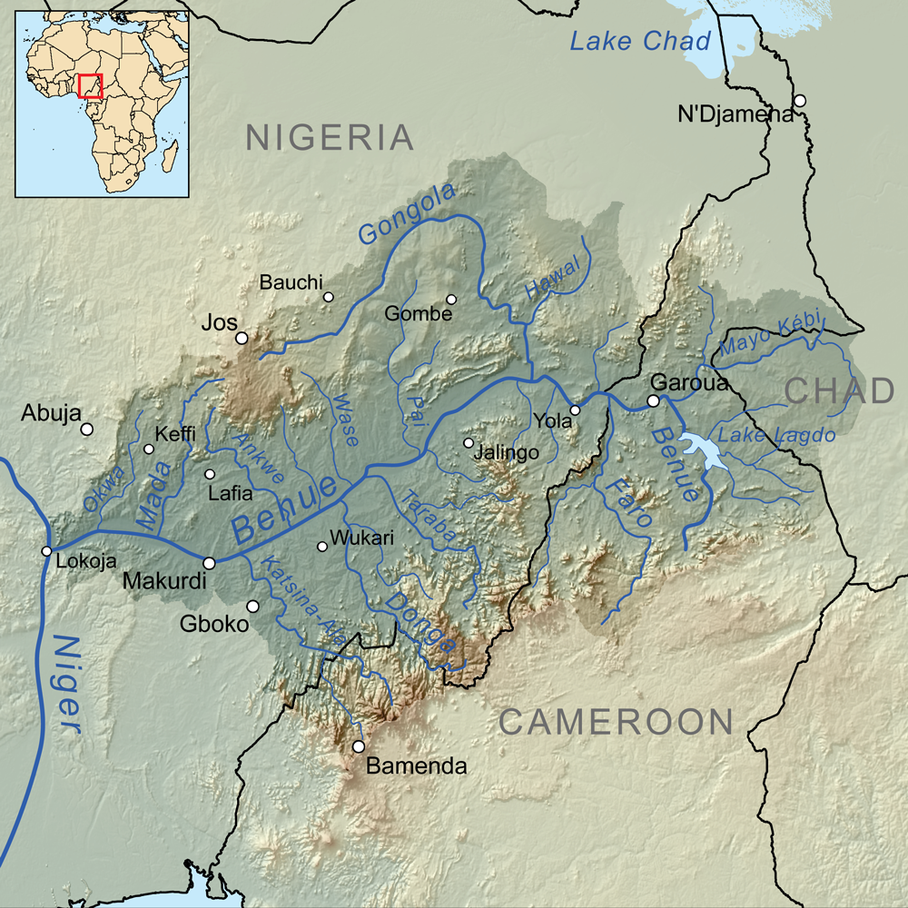
| BeskriuwingBenuerivermap.png | Map showing the Benue River drainage basin. |
| Datum | |
| Boarne | Eigen wurk, Elevation data from SRTM, drainage basin from GTOPO [1], all other features from Vector Map. |
| Auteur | Kmusser |
Lisinsje
I, the copyright holder of this work, hereby publish it under the following license:
This file is licensed under the Creative Commons Attribution-Share Alike 3.0 Unported license.
- Fiel jo frij:
- te dielen – it wurk te kopiearjen, fersprieden en út te stjoeren
- te fermingen – it wurk oan te passen
- Under de neikommende betingsten:
- Nammefermelding – You must give appropriate credit, provide a link to the license, and indicate if changes were made. You may do so in any reasonable manner, but not in any way that suggests the licensor endorses you or your use.
- Lyk diele – If you remix, transform, or build upon the material, you must distribute your contributions under the same or compatible license as the original.
Captions
Add a one-line explanation of what this file represents
Items portrayed in this file
depicts Ingelsk
some value
copyright status Ingelsk
copyrighted Ingelsk
inception Ingelsk
1 apr 2010
source of file Ingelsk
original creation by uploader Ingelsk
media type Ingelsk
image/png
checksum Ingelsk
a0b34f4a7b4df58a3e80beca9c28e8f940eccbae
data size Ingelsk
1.587.527 byte
height Ingelsk
1.000 pixel
width Ingelsk
1.000 pixel
Triemskiednis
Klik op in datum/tiid om it bestân te besjen sa't it op dat stuit wie.
| Datum/Tiid | Miniatuer | ôfmjittings | Meidogger | Opmerking | |
|---|---|---|---|---|---|
| lêste | 8 okt 2010, 18.00 | | 1.000 × 1.000 (1,51 MB) | Kmusser | +Wukari |
| 7 apr 2010, 18.06 |  | 1.000 × 1.000 (1,63 MB) | Kmusser | +N'Djamena | |
| 7 apr 2010, 18.02 |  | 1.000 × 1.000 (1,63 MB) | Kmusser | Flip basin highlighting | |
| 1 apr 2010, 17.35 |  | 1.000 × 1.000 (1,51 MB) | Kmusser | == Summary == {{Information |Description=Map showing the Benue River drainage basin. |Source={{own}}, Elevation data from SRTM, drainage basin from GTOPO [http://eros.usgs.gov/#/Find_Data/Products |
Bestânsgebrûk
De neikommende side brûkt dit bestân:
Globaal bestânsgebrûk
De neikommende oare wiki's brûke dit bestân:
- Gebrûk op af.wikipedia.org
- Gebrûk op ar.wikipedia.org
- Gebrûk op arz.wikipedia.org
- Gebrûk op ast.wikipedia.org
- Gebrûk op ba.wikipedia.org
- Gebrûk op be.wikipedia.org
- Gebrûk op bg.wikipedia.org
- Gebrûk op bs.wikipedia.org
- Gebrûk op ca.wikipedia.org
- Gebrûk op cs.wikipedia.org
- Gebrûk op da.wikipedia.org
- Gebrûk op de.wikipedia.org
- Gebrûk op el.wikipedia.org
- Gebrûk op en.wikipedia.org
- Gebrûk op eo.wikipedia.org
- Gebrûk op es.wikipedia.org
- Gebrûk op eu.wikipedia.org
- Gebrûk op fi.wikipedia.org
- Gebrûk op fr.wikipedia.org
- Gebrûk op gl.wikipedia.org
- Gebrûk op ha.wikipedia.org
- Gebrûk op he.wikipedia.org
Mear globaal gebrûk fan dit bestân besjen.
Opfrege fan "https://fy.wikipedia.org/wiki/Ofbyld:Benuerivermap.png"