Íomhá:SevenYearsWar.png
From Wikipedia, the free encyclopedia
Size of this preview: 800 × 370 picteilín. Other resolutions: 320 × 148 picteilín | 640 × 296 picteilín | 1,357 × 628 picteilín.
Taispeáin leagan ardtaifigh den íomhá (1,357 × 628 picteilín, méid comhaid: 41 KB, cineál MIME: image/png)
| Seo comhad as An Cómhaoin Viciméid. Tá an tuairisc as an leathanach tuairisc Cómhaoin a leanas thíos.
|

|
This military map image could be re-created using vector graphics as an SVG file. This has several advantages; see Commons:Media for cleanup for more information. If an SVG form of this image is available, please upload it and afterwards replace this template with
{{vector version available|new image name}}.
It is recommended to name the SVG file “SevenYearsWar.svg”—then the template Vector version available (or Vva) does not need the new image name parameter. |
Achoimriú
| TuairiscSevenYearsWar.png |
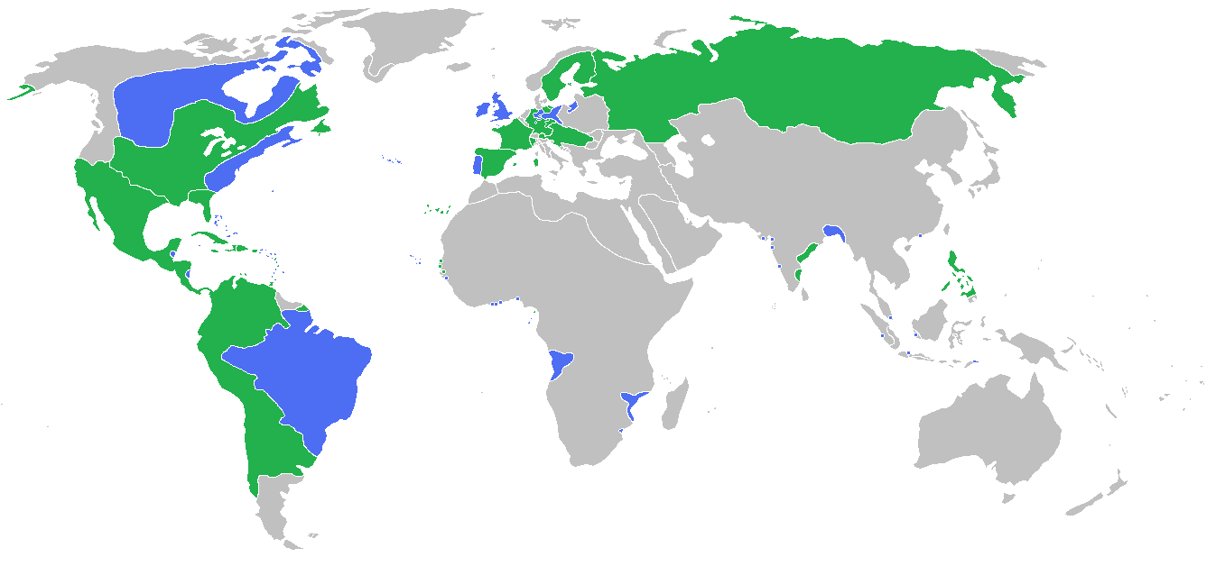
English: Locator map of the competing sides of the Seven Years War before outset of the war (mid-1750s). Blue: Great Britain, Portugal with more. Green: France, Spain with more. Français : Carte montrant les forces en présence lors de la guerre de Sept Ans (milieu des années 1750).
(Partially based on Atlas of World History (2007) - There was also a treaty in 1783, Imperialism and Revolutions, map) |
| Dáta | |
| Foinse | Obair féin |
| Údar | Gabagool |
Ceadúnú
Is mise sealbhóir cóipchirt an shaothair seo agus foilsím é faoin gceadúnas seo a leanas:
This file is licensed under the Creative Commons Attribution 3.0 Unported license.
- Is féidir:
- an saothar seo a roinnt – an saothar seo a chóipeáil, a dháil amach, agus a tharchur
- an saothar seo a athmheascadh – an saothar seo a oiriúnú
- Ach amháin má leantar na coinníollacha seo a leanas:
- sannadh – Ní mor creidiúint a thabhairt leis an saothar, faoi mar a shonraigh an údar nó tabharthóir an ceadúnais (ach ná húsáid modh a thugann le fios go thacaíonn sé/sí tú féin nó an úsáid a bhaineann tú as an saothar).
Captions
Add a one-line explanation of what this file represents
Map of the alliances in the Seven Years' War
Karte der Bündnisse im Siebenjährigen Krieg
Items portrayed in this file
taispeánann sé/sí
some value
source of file Béarla
7 Meitheamh 2009
media type Béarla
image/png
Stair chomhaid
Cliceáil ar dáta/am chun an comhad a radharc mar a bhí sé ag an am sin.
| Dáta/Am | Mionsamhail | Toisí | Úsáideoir | Nóta tráchta | |
|---|---|---|---|---|---|
| faoi láthair | 15:54, 23 Meitheamh 2009 | | 1,357 × 628 (41 KB) | Gabagool | corrected India more appropriatly |
| 13:59, 11 Meitheamh 2009 |  | 1,357 × 628 (41 KB) | Gabagool | some fixes | |
| 11:16, 11 Meitheamh 2009 |  | 1,357 × 628 (41 KB) | Gabagool | more details in Germany | |
| 22:20, 6 Meitheamh 2009 |  | 1,357 × 628 (41 KB) | Gabagool | {{Information |Description={{en|1=Locator map of the competing sides of the Seven Years War before outset of the war (early 1750s).<br> Blue: Great Britain, Portugal with more. Green: France, Spain with more. Light green: French largest expansion in India |
Úsáid comhaid
Tá nasc chuig an gcomhad seo ar na leathanaigh seo a leanas:
Global file usage
The following other wikis use this file:
- Úsáid ar af.wikipedia.org
- Úsáid ar als.wikipedia.org
- Úsáid ar an.wikipedia.org
- Úsáid ar ar.wikipedia.org
- Úsáid ar arz.wikipedia.org
- Úsáid ar ast.wikipedia.org
- Úsáid ar az.wikipedia.org
- Úsáid ar ba.wikipedia.org
- Úsáid ar bg.wikipedia.org
- Úsáid ar bn.wikipedia.org
- Úsáid ar br.wikipedia.org
- Úsáid ar bs.wikipedia.org
- Úsáid ar ca.wikipedia.org
- Úsáid ar cs.wikipedia.org
- Úsáid ar da.wikipedia.org
- Úsáid ar de.wikipedia.org
- Úsáid ar dsb.wikipedia.org
- Úsáid ar en.wikipedia.org
- Úsáid ar eo.wikipedia.org
- Úsáid ar es.wikipedia.org
- Úsáid ar fa.wikipedia.org
- Úsáid ar fi.wikipedia.org
- Úsáid ar fr.wikipedia.org
- Úsáid ar he.wikipedia.org
- Úsáid ar hi.wikipedia.org
- Úsáid ar hsb.wikipedia.org
- Úsáid ar is.wikipedia.org
- Úsáid ar it.wikipedia.org
- Úsáid ar ja.wikipedia.org
- Úsáid ar ko.wikipedia.org
- Úsáid ar lt.wikipedia.org
View more global usage of this file.