קובץ:AGHRC_(1890)_-_Carta_IV_-_Virreinato_de_Santafé_y_Capitanía_General_de_Venezuela.jpg
ויקיפדיה האנציקלופדיה encyclopedia
לקובץ המקורי (4,310 × 3,478 פיקסלים, גודל הקובץ: 5.73 מ"ב, סוג MIME: image/jpeg)
| זהו קובץ שמקורו במיזם ויקישיתוף. תיאורו בדף תיאור הקובץ המקורי (בעברית) מוצג למטה. |
תקציר
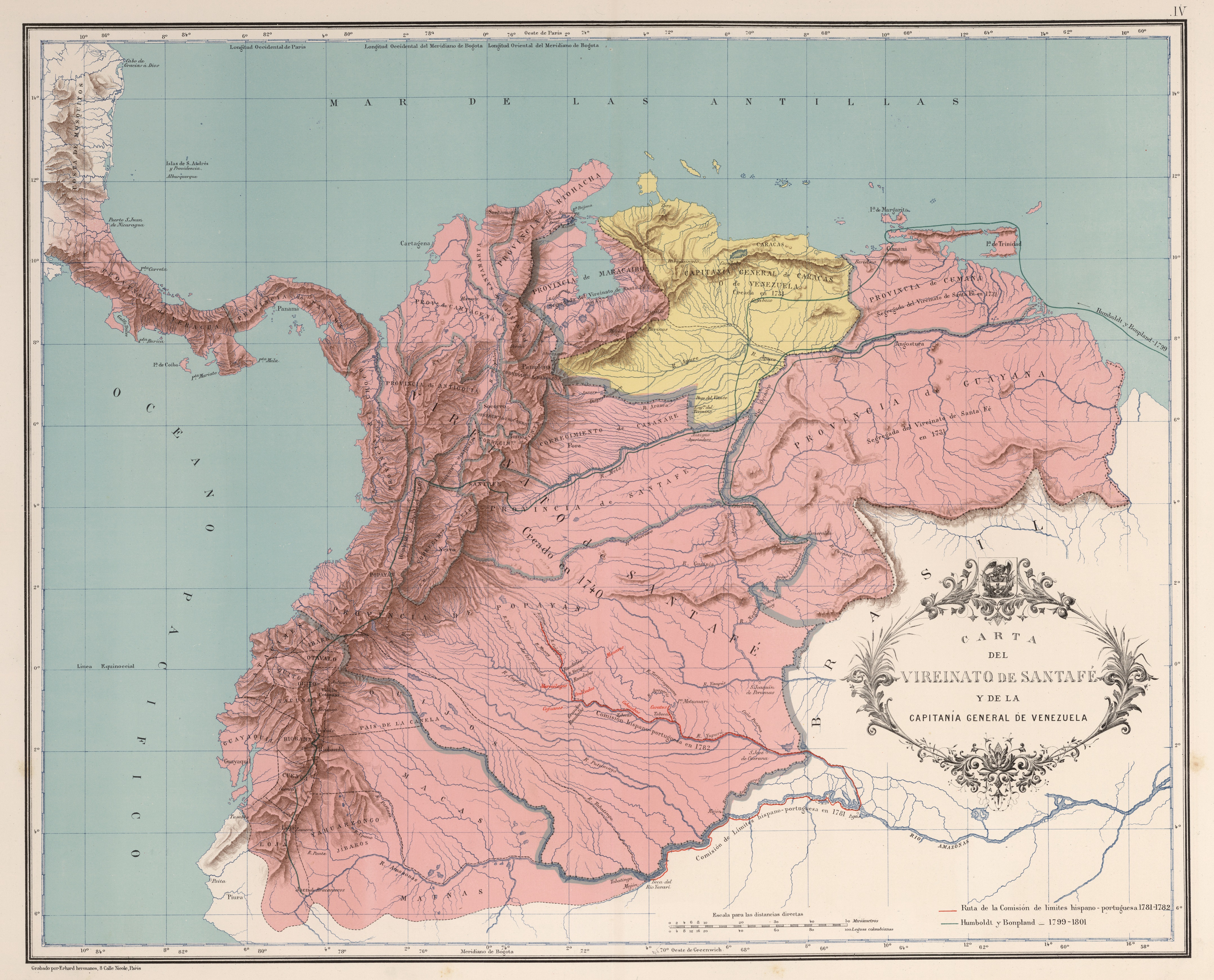
| תיאורAGHRC (1890) - Carta IV - Virreinato de Santafé y Capitanía General de Venezuela.jpg |
Español: Carta del Virreinato de Santafé y la Capitanía General de Venezuela (1742). Carta IV del Atlas geográfico e histórico de la República de Colombia, 1890. |
||||||||||||||||||||
| תאריך יצירה | |||||||||||||||||||||
| מקור | Atlas geográfico e histórico de la República de Colombia, 1890. | ||||||||||||||||||||
| יוצר |
creator QS:P170,Q1888523 , Manuel Maria Paz, Felipe Pérez |
||||||||||||||||||||

_-_Carta_III_-_Presidencias_de_Santaf%C3%A9_y_Quito.jpg)
_-_Carta_V_-_Divisi%C3%B3n_pol%C3%ADtica_del_Virreinato_de_Santaf%C3%A9,_1810.jpg)
רישיון
| Public domainPublic domainfalsefalse |
This file is in the public domain because the copyright of this work, registered in Colombia, has expired, according to “Law 23 of 1982 on Copyright, Articles 11, 21-29”, amended by “Law 44 of 1993, Article 2” and “Law 1520 of 2012, Articles 4, 6 and 10” (details). However, some restrictions have to be addressed:
|

|
כיתובים
פריטים שמוצגים בקובץ הזה
מוצג
image/jpeg
6,010,867 בית
3,478 פיקסל
4,310 פיקסל
היסטוריית הקובץ
ניתן ללחוץ על תאריך/שעה כדי לראות את הקובץ כפי שנראה באותו זמן.
| תאריך/שעה | תמונה ממוזערת | ממדים | משתמש | הערה | |
|---|---|---|---|---|---|
| נוכחית | 16:34, 28 בנובמבר 2018 | | 3,478 × 4,310 (5.73 מ"ב) | Milenioscuro | high quality (from David Rumsey) |
| 07:26, 20 במרץ 2009 |  | 2,344 × 2,861 (2.97 מ"ב) | Milenioscuro | {{Information |Description={{es|1=Carta del Virreinato de Santafé y la Capitanía General de Venezuela. Tomado del "Atlas geográfico e histórico de la República de Colombia", 1890.}} |Source=Atlas geográfico e histórico de la República de Colombia, |
שימוש בקובץ
הדף הבא משתמש בקובץ הזה:
שימוש גלובלי בקובץ
אתרי הוויקי השונים הבאים משתמשים בקובץ זה:
- שימוש באתר ast.wikipedia.org
- שימוש באתר ca.wikipedia.org
- שימוש באתר cs.wikipedia.org
- שימוש באתר de.wikipedia.org
- שימוש באתר en.wikipedia.org
- שימוש באתר es.wikipedia.org
- Virreinato de Nueva Granada
- Compañía Guipuzcoana
- Capitanía general de Venezuela
- Batalla de Bocachica
- Época de la colonia (Venezuela)
- Provincia de Venezuela
- Organización territorial del Virreinato de Nueva Granada
- Historia política de Colombia
- Conflicto limítrofe entre el Perú y Colombia
- Protocolo Pedemonte-Mosquera
- שימוש באתר eu.wikipedia.org
- שימוש באתר fr.wikipedia.org
- שימוש באתר gl.wikipedia.org
- שימוש באתר it.wikipedia.org
- שימוש באתר pt.wikipedia.org
- שימוש באתר ru.wikipedia.org
- שימוש באתר sh.wikipedia.org
- שימוש באתר sk.wikipedia.org
- שימוש באתר uk.wikipedia.org
מטא־נתונים
קובץ זה מכיל מידע נוסף, שכנראה הגיע ממצלמה דיגיטלית או מסורק שבהם הקובץ נוצר או עבר דיגיטציה.
אם הקובץ שונה ממצבו הראשוני, כמה מהנתונים להלן עלולים שלא לשקף באופן מלא את הקובץ הנוכחי.
| רוחב | 4,366 px |
|---|---|
| גובה | 3,524 px |
| ביטים לרכיב |
|
| תבנית דחיסה | לא דחוס |
| הרכב פיקסלים | RGB |
| מספר רכיבים | 3 |
| מספר השורות לרצועה | 7 |
| רזולוציה אופקית | 96 dpc |
| רזולוציה אנכית | 96 dpc |
_-_Carta_IV_-_Virreinato_de_Santafé_y_Capitanía_General_de_Venezuela.jpg)