קובץ:Deepwater_Horizon_oil_spill_-_May_24,_2010_-_with_locator.jpg
ויקיפדיה האנציקלופדיה encyclopedia
לקובץ המקורי (2,118 × 1,628 פיקסלים, גודל הקובץ: 385 ק"ב, סוג MIME: image/jpeg)
| זהו קובץ שמקורו במיזם ויקישיתוף. תיאורו בדף תיאור הקובץ המקורי (בעברית) מוצג למטה. |
תקציר
|
| תיאורDeepwater Horizon oil spill - May 24, 2010 - with locator.jpg |
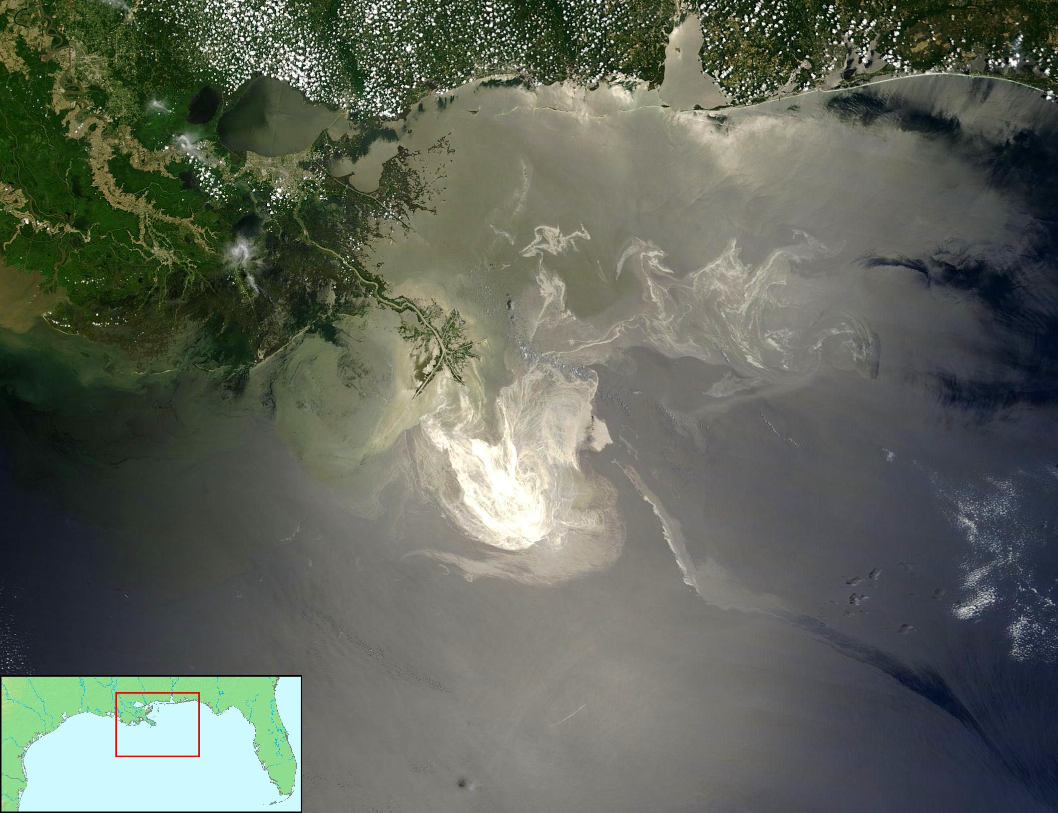
English: Description from NASA (source):
"NASA's Terra Satellites Sees Spill on May 24 Sunlight illuminated the lingering oil slick off the Mississippi Delta on May 24, 2010. The Moderate-Resolution Imaging Spectroradiometer (MODIS) on NASA’s Terra satellite captured this image the same day. Oil smoothes the ocean surface, making the Sun’s reflection brighter near the centerline of the path of the satellite, and reducing the scattering of sunlight in other places. As a result, the oil slick is brighter than the surrounding water in some places (image center) and darker than the surrounding water in others (image lower right). The tip of the Mississippi Delta is surrounded by muddy water that appears light tan. Bright white ribbons of oil streak across this sediment-laden water. Tendrils of oil extend to the north and east of the main body of the slick. A small, dark plume along the edge of the slick, not far from the original location of the Deepwater Horizon rig, indicates a possible controlled burn of oil on the ocean surface. To the west of the bird’s-foot part of the delta, dark patches in the water may also be oil, but detecting a manmade oil slick in coastal areas can be even more complicated than detecting it in the open ocean. When oil slicks are visible in satellite images, it is because they have changed how the water reflects light, either by making the Sun’s reflection brighter or by dampening the scattering of sunlight, which makes the oily area darker. In coastal areas, however, similar changes in reflectivity can occur from differences in salinity (fresh versus salt water) and from naturally produced oils from plants. Michon Scott NASA's Earth Observatory NASA Goddard Space Flight Center"
Français : Traduction partielle de la description par la NASA(source): La marée noire causée par l'incendie de la plateforme pétrolière Deepwater Horizon vue par le satellite Terra, de la NASA, le 24 mai 2010.
Cette image a été acquise par le Moderate-Resolution Imaging Spectroradiometer (MODIS, pour Spectroradiomètre d'imagerie à résolution moyenne), embarqué sur le satellite Terra. Le pétrole lisse la surface de l'océan, ce qui la rend plus claire là où elle réfléchit le soleil (par exemple, au centre de la photo) et plus sombre ailleurs (par exemple en bas à droite). Le delta du Mississippi est visible en haut, entouré d'eaux saumâtres et boueuses qui apparaissent en brun, rayé de rubans argentés de pétrole. |
||||||
| תאריך יצירה | |||||||
| מקור |
1/ File:Deepwater Horizon oil spill - May 24, 2010.jpg (based upon Original image with cropping) 2/ Locator by FT2 from File:Map of USA topological.png (Public domain by author demis.nl). |
||||||
| יוצר | NASA/GSFC, MODIS Rapid Response AND demis.nl AND FT2 | ||||||
| אישורים והיתרים (שימוש חוזר בקובץ זה) |
Combined with other public domain source imagery. I as compositor of these two public domain images also release my work into the public domain - FT2 |
||||||
| גרסאות אחרות |
|


כיתובים
פריטים שמוצגים בקובץ הזה
מוצג
18 ביוני 2010
image/jpeg
היסטוריית הקובץ
ניתן ללחוץ על תאריך/שעה כדי לראות את הקובץ כפי שנראה באותו זמן.
| תאריך/שעה | תמונה ממוזערת | ממדים | משתמש | הערה | |
|---|---|---|---|---|---|
| נוכחית | 03:10, 19 ביוני 2010 | | 1,628 × 2,118 (385 ק"ב) | FT2 | {{Information |Description={{en|1=to add}} |Source=to add |Author=to add |Date=2010-01-01 |Permission={{PD}} |other_versions=Deepwater Horizon oil spill - May 24, 2010.jpg }} |
שימוש בקובץ
הדף הבא משתמש בקובץ הזה:
שימוש גלובלי בקובץ
אתרי הוויקי השונים הבאים משתמשים בקובץ זה:
- שימוש באתר ar.wikipedia.org
- שימוש באתר ast.wikipedia.org
- שימוש באתר bg.wikipedia.org
- שימוש באתר ca.wikipedia.org
- שימוש באתר de.wikipedia.org
- שימוש באתר en.wikipedia.org
- שימוש באתר en.wikibooks.org
- שימוש באתר en.wikinews.org
- שימוש באתר en.wikiquote.org
- שימוש באתר es.wikipedia.org
- שימוש באתר fr.wikipedia.org
- שימוש באתר gl.wikipedia.org
- שימוש באתר hu.wikipedia.org
- שימוש באתר it.wikipedia.org
- שימוש באתר ja.wikipedia.org
- שימוש באתר ko.wikipedia.org
- שימוש באתר krc.wikipedia.org
- שימוש באתר lv.wikipedia.org
- שימוש באתר ml.wikipedia.org
- שימוש באתר ms.wikipedia.org
- שימוש באתר my.wikipedia.org
- שימוש באתר pt.wikipedia.org
- שימוש באתר th.wikipedia.org
- שימוש באתר tr.wikipedia.org
- Vikipedi:Seçkin resimler/Uzay/Dünya'ya bakış
- Vikipedi:Günün seçkin resmi/Şubat 2012
- Deepwater Horizon petrol sızıntısı
- Vikipedi:Seçkin resim adayları/Deepwater Horizon oil spill - May 24, 2010 - with locator.jpg
- Vikipedi:Seçkin resim adayları/Arşiv/Mart 2011
- Kullanıcı:Ahzaryamed/arşiv-06.11.2010-21.04.2011
- Şablon:GSR/2012-02-04
- Vikipedi:Seçkin resimler/Ana sayfaya çıkmış resimler/2012 listesi
- Vikipedi:Seçkin resimler/Ana sayfaya çıkmış resimler/2014 listesi
- Vikipedi:Günün seçkin resmi/Mayıs 2014
- Şablon:GSR/2014-05-13
- Şablon:GSR/2017-03-26
- Portal:Meksika/Seçilen resim
מטא־נתונים
קובץ זה מכיל מידע נוסף, שכנראה הגיע ממצלמה דיגיטלית או מסורק שבהם הקובץ נוצר או עבר דיגיטציה.
אם הקובץ שונה ממצבו הראשוני, כמה מהנתונים להלן עלולים שלא לשקף באופן מלא את הקובץ הנוכחי.
| _error | 0 |
|---|