קובץ:Great_Salt_Lake_ISS_2003.jpg
ויקיפדיה האנציקלופדיה encyclopedia
גודל התצוגה המקדימה הזאת: 612 × 600 פיקסלים. רזולוציות אחרות: 245 × 240 פיקסלים | 490 × 480 פיקסלים | 996 × 976 פיקסלים.
לקובץ המקורי (996 × 976 פיקסלים, גודל הקובץ: 248 ק"ב, סוג MIME: image/jpeg)
| זהו קובץ שמקורו במיזם ויקישיתוף. תיאורו בדף תיאור הקובץ המקורי (בעברית) מוצג למטה. |
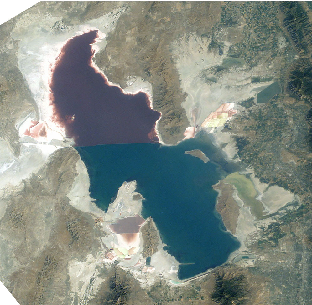
Great Salt Lake from German Wikipedia
- Description:
- Great Salt Lake, Utah, to the right (east) are the Wasatch Mountains, to the lower right is Salt Lake City, Utah. This photo is taken from the International Space Station from approximately 380 km. The railway clearly separates the north and south sections of the lake, which have different salt concentrations due to the barrier. The northern section ( Gunnison Bay) is at least two times more salty than the southern one, and shows a pink or mauve color. The water level of the lake is very low: note that the northeast arm of the lake has disappeared, and that Antelope Island is no longer an island at all.
- Sequence of landforms (west-to-east), north:
en:Curlew Valley, en:Hansel Mountains, Hansel Valley, North Promontory Mountains, en:Blue Creek Valley, Blue Spring Hills, Penrose-Bothwell, Utah - Islands:
en:Stansbury Island, en:Antelope Island, en:Fremont Island-(north) - Sequence, south:
(en:Lakeside Mountains), en:Cedar Mountains (Tooele County), en:Skull Valley (Utah), en:Stansbury Mountains, Tooele Valley, en:Oquirrh Mountains, SLC - West lake: en:Hogup Mountains, (northwest), en:Lakeside Mountains, (southwest)
- Lake center: en:Promontory Mountains
- Sequence of landforms (west-to-east), north:
- Date: 19 August 2003, GMT time: 16:37
- Colors adapted: geographically coded
- Great Salt Lake, Utah, to the right (east) are the Wasatch Mountains, to the lower right is Salt Lake City, Utah. This photo is taken from the International Space Station from approximately 380 km. The railway clearly separates the north and south sections of the lake, which have different salt concentrations due to the barrier. The northern section ( Gunnison Bay) is at least two times more salty than the southern one, and shows a pink or mauve color. The water level of the lake is very low: note that the northeast arm of the lake has disappeared, and that Antelope Island is no longer an island at all.
- Source:
- NASA's Earth Observatory [1]
- License:
| Public domainPublic domainfalsefalse |
| קובץ זה נמצא ברשות הציבור מכיוון שהוא נוצר על ידי נאס"א. מדיניות זכויות היוצרים של נאס"א קובעת ש"חומרים של NASA אינם מוגנים בזכויות יוצרים אלא אם צוין אחרת". (דף מדיניות זכויות היוצרים ב-NASA או מדיניות שימוש בתמונות ב-JPL). | ||
 |
אזהרות:
|
From : http://en.wikipedia.org/wiki/Image:Great_Salt_Lake_ISS_2003.JPG
| Annotations InfoField | This image is annotated: View the annotations at Commons |
221
442
312
42
996
976
Lucin Cutoff
כיתובים
נא להוסיף משפט שמסביר מה הקובץ מייצג
The Great Salt Lake (an endorheic lake) in Utah, taken from the International space station.
Большое Солёное Озеро , США, фото с МКС
פריטים שמוצגים בקובץ הזה
מוצג
Jack Boucher אנגלית
image/jpeg
היסטוריית הקובץ
ניתן ללחוץ על תאריך/שעה כדי לראות את הקובץ כפי שנראה באותו זמן.
| תאריך/שעה | תמונה ממוזערת | ממדים | משתמש | הערה | |
|---|---|---|---|---|---|
| נוכחית | 12:09, 11 בנובמבר 2005 | | 976 × 996 (248 ק"ב) | Urban~commonswiki | Great Salt Lake from German Wikipedia * Description: ** Great Salt Lake, Utah, to the right (east) are the Wasatch Mountains, to the lower right is Salt Lake City, Utah. This photo is taken from the International Space Station from a |
שימוש בקובץ
הדפים הבאים משתמשים בקובץ הזה:
שימוש גלובלי בקובץ
אתרי הוויקי השונים הבאים משתמשים בקובץ זה:
- שימוש באתר ar.wikipedia.org
- שימוש באתר arz.wikipedia.org
- שימוש באתר az.wikipedia.org
- שימוש באתר be.wikipedia.org
- שימוש באתר bn.wikipedia.org
- שימוש באתר br.wikipedia.org
- שימוש באתר ceb.wikipedia.org
- שימוש באתר cv.wikipedia.org
- שימוש באתר da.wikipedia.org
- שימוש באתר de.wikipedia.org
- שימוש באתר el.wikipedia.org
- שימוש באתר en.wikipedia.org
- Jim Bridger
- Endorheic basin
- User:Cool Hand Luke/Photos
- Portal:United States/Selected article/2006, week 37
- Portal:United States/Selected article/2006, week 38
- Portal:United States/Selected article/2006, week 39
- Portal:United States/Selected article/2006, week 40
- Wikipedia:WikiProject Lakes/Galleries/1
- Endorheic lake
- Blue Creek Valley
- שימוש באתר eo.wikipedia.org
- שימוש באתר es.wikipedia.org
- שימוש באתר et.wikipedia.org
- שימוש באתר fa.wikipedia.org
- שימוש באתר fi.wikipedia.org
- שימוש באתר fr.wikipedia.org
- Grand Lac Salé
- Lac Bonneville
- Wikipédia:Lumière sur/Juin 2008
- Wikipédia:Lumière sur/Grand Lac Salé
- Wikipédia:Sélection/Géographie
- Wikipédia:Sélection/Eau
- Wikipédia:Sélection/Utah
- Portail:Information géographique/Sélection
- Wikipédia:Sélection/Lacs et cours d'eau
- Portail:Salt Lake City
- Wikipédia:Sélection/Salt Lake City
- Wikipédia:Sélection/États-Unis/Bons articles/Partie II
- Julie Moschelesová
- שימוש באתר hi.wikipedia.org
- שימוש באתר hu.wikipedia.org
- שימוש באתר hy.wikipedia.org
- שימוש באתר id.wikipedia.org
- שימוש באתר incubator.wikimedia.org
מטא־נתונים
קובץ זה מכיל מידע נוסף, שכנראה הגיע ממצלמה דיגיטלית או מסורק שבהם הקובץ נוצר או עבר דיגיטציה.
אם הקובץ שונה ממצבו הראשוני, כמה מהנתונים להלן עלולים שלא לשקף באופן מלא את הקובץ הנוכחי.
| כיוון מצלמה | רגילה |
|---|---|
| רזולוציה אופקית | 300 dpi |
| רזולוציה אנכית | 300 dpi |
| תוכנה בשימוש | Adobe Photoshop 7.0 |
| התאריך והשעה של שינוי הקובץ | 11:45, 9 בינואר 2004 |
| מרחב הצבע | ללא כיול צבעים |