Fájl:2020-12-29_Petrinja,_Croatia_M6.4_earthquake_shakemap_(USGS).jpg
From Wikipedia, the free encyclopedia
Az előnézet mérete: 472 × 599 képpont További felbontások: 189 × 240 képpont | 378 × 480 képpont | 787 × 999 képpont.
Eredeti fájl (787 × 999 képpont, fájlméret: 462 KB, MIME-típus: image/jpeg)
|
Ez a fájl a Wikimedia Commonsból származik. Az alább látható leírás az ottani dokumentációjának másolata. A Commons projekt szabad licencű kép- és multimédiatár. Segíts te is az építésében! |
Összefoglaló
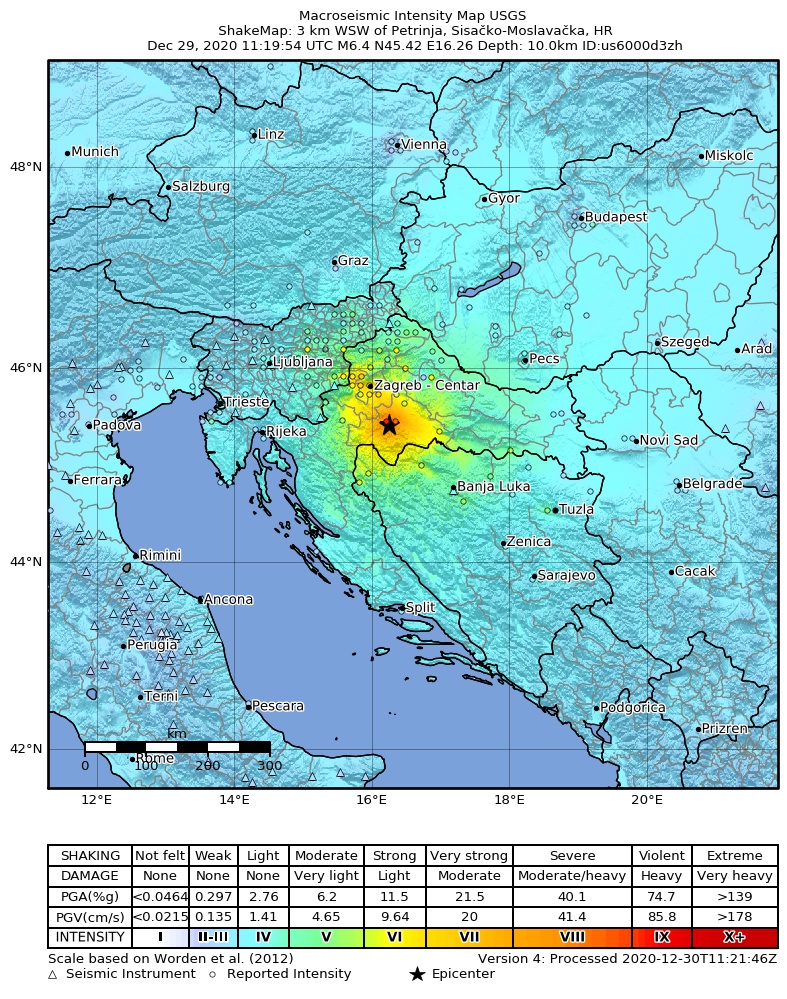
| Leírás2020-12-29 Petrinja, Croatia M6.4 earthquake shakemap (USGS).jpg |
English: Shakemap from USGS for the magnitude 6.4, maximum intensity 6.826 earthquake near en:Usgs Neic Shakemap (2 km SSE of en:Petrinja, Croatia), 10.0 km depth. |
| Dátum | |
| Forrás | https://earthquake.usgs.gov/earthquakes/eventpage/us6000d3zh |
| Szerző | United States Geological Survey |
Licenc
| Public domainPublic domainfalsefalse |
This image is in the public domain in the United States because it only contains materials that originally came from the United States Geological Survey, an agency of the United States Department of the Interior. For more information, see the official USGS copyright policy.
Bahasa Indonesia ∙ català ∙ čeština ∙ Deutsch ∙ eesti ∙ English ∙ español ∙ français ∙ galego ∙ italiano ∙ Nederlands ∙ português ∙ polski ∙ sicilianu ∙ suomi ∙ Tiếng Việt ∙ Türkçe ∙ български ∙ македонски ∙ русский ∙ മലയാളം ∙ 한국어 ∙ 日本語 ∙ 中文 ∙ 中文(简体) ∙ 中文(繁體) ∙ العربية ∙ فارسی ∙ +/− |
Képaláírások
Adj meg egy egysoros magyarázatot arról, hogy mit mutat be ez a fájl
petrinja ,earthquake
A fájl által ábrázolt elemek
mű tárgya
29. december 2020
image/jpeg
addf90cba47b8e99404d07531d2684ef0215ec97
473 187 byte
999 képpont
787 képpont
Fájltörténet
Kattints egy időpontra, hogy a fájl akkori állapotát láthasd.
| Dátum/idő | Bélyegkép | Felbontás | Feltöltő | Megjegyzés | |
|---|---|---|---|---|---|
| aktuális | 2020. december 31., 14:30 | | 787 × 999 (462 KB) | IllCom | new version by USGS |
| 2020. december 30., 00:10 |  | 787 × 999 (460 KB) | IllCom | new version by USGS | |
| 2020. december 29., 15:10 |  | 787 × 999 (460 KB) | IllCom | new version by USGS | |
| 2020. december 29., 14:03 |  | 787 × 999 (454 KB) | Cewbot | Import USGS earthquake map, shakemap id: urn:usgs-product:us:shakemap:us6000d3zh:1609242281073 (2020-12-29T11:44:41.073Z) |
Fájlhasználat
Az alábbi lap használja ezt a fájlt:
Globális fájlhasználat
A következő wikik használják ezt a fájlt:
- Használata itt: bs.wikipedia.org
- Használata itt: cs.wikipedia.org
- Használata itt: de.wikipedia.org
- Használata itt: el.wikipedia.org
- Használata itt: en.wikipedia.org
- Használata itt: es.wikipedia.org
- Használata itt: fa.wikipedia.org
- Használata itt: fi.wikipedia.org
- Használata itt: hr.wikipedia.org
- Használata itt: id.wikipedia.org
- Használata itt: it.wikipedia.org
- Használata itt: meta.wikimedia.org
- Használata itt: pl.wikipedia.org
- Használata itt: ru.wikipedia.org
- Használata itt: sh.wikipedia.org
- Használata itt: sl.wikipedia.org
- Használata itt: sv.wikipedia.org
- Használata itt: ta.wikipedia.org
- Használata itt: th.wikipedia.org
- Használata itt: tr.wikipedia.org
- Használata itt: www.wikidata.org
- Használata itt: zh.wikipedia.org
.jpg)