File:C77190s1_Ant.Map_Ross_Island.jpg
Da Wikipedia, l'enciclopedia encyclopedia
File originale (5 118 × 3 249 pixel, dimensione del file: 1,95 MB, tipo MIME: image/jpeg)
| Questo file e la sua pagina di descrizione (discussione · modifica) si trovano su Wikimedia Commons (?) |
| DescrizioneC77190s1 Ant.Map Ross Island.jpg |
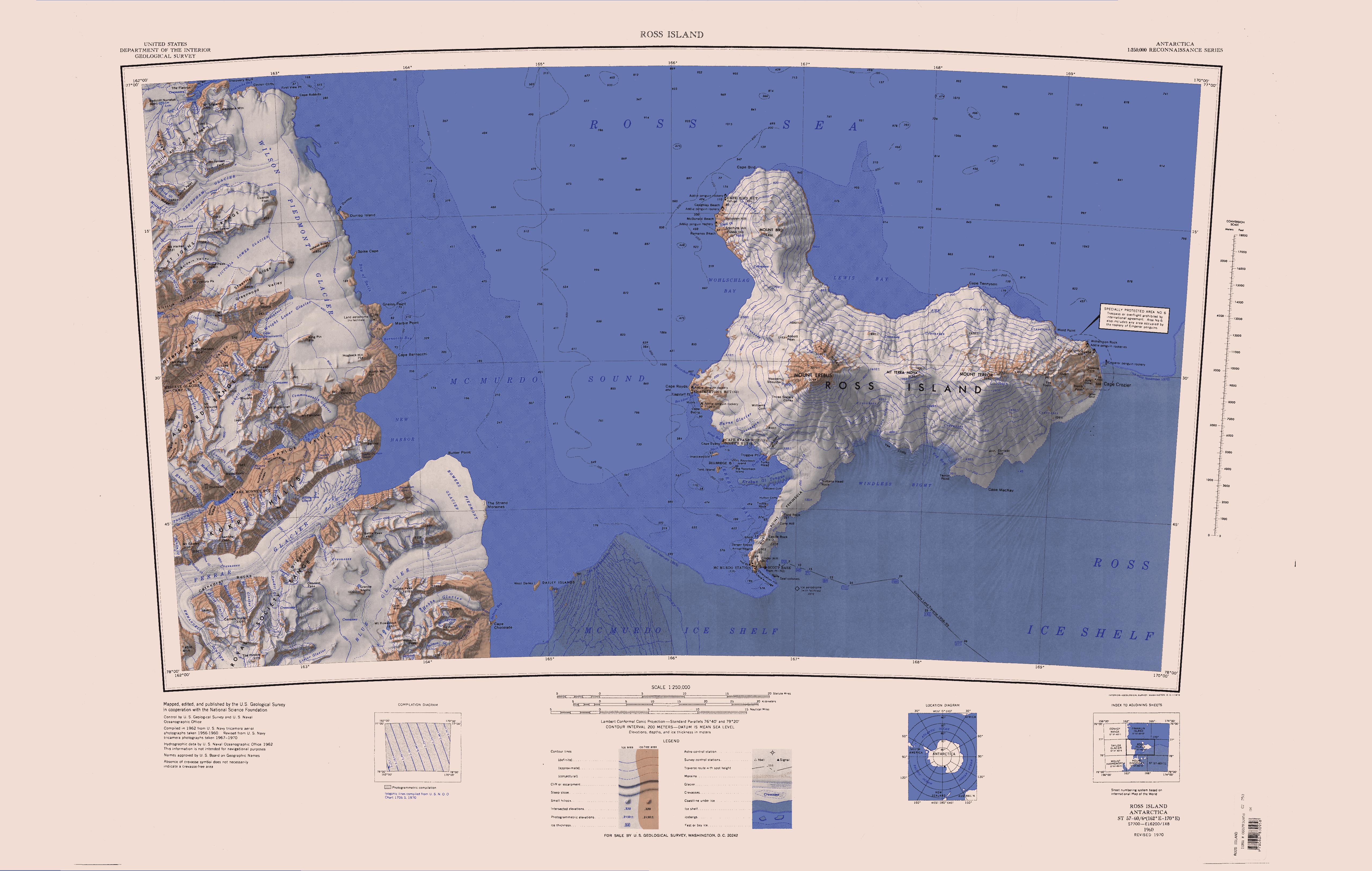
English: Map of Antarctica by the United States Antarctic Resource Center of the US Geological Society. |
| Fonte | USGS |
| Autore | USGS |
| Altre versioni | File:Ross Island Topographic Map USGS.png : Higher quality PNG version |
| Public domainPublic domainfalsefalse |
Quest'immagine è nel pubblico dominio perché contiene materiale proveniente dallo United States Geological Survey, un'agenzia del Dipartimento degli Interni degli Stati Uniti. Per maggiori informazioni vedere la politica ufficiale dell'USGS sul copyright.
Bahasa Indonesia ∙ català ∙ čeština ∙ Deutsch ∙ eesti ∙ English ∙ español ∙ français ∙ galego ∙ italiano ∙ Nederlands ∙ português ∙ polski ∙ sicilianu ∙ suomi ∙ Tiếng Việt ∙ Türkçe ∙ български ∙ македонски ∙ русский ∙ മലയാളം ∙ 한국어 ∙ 日本語 ∙ 中文 ∙ 中文(简体) ∙ 中文(繁體) ∙ العربية ∙ فارسی ∙ +/− |
Didascalie
Elementi ritratti in questo file
raffigura
image/jpeg
d1b1c1edeecbde9cf2ba07ae8a405c3d58c61330
2 046 214 byte
3 249 pixel
5 118 pixel
Cronologia del file
Fare clic su un gruppo data/ora per vedere il file come si presentava nel momento indicato.
| Data/Ora | Miniatura | Dimensioni | Utente | Commento | |
|---|---|---|---|---|---|
| attuale | 14:01, 15 apr 2005 | | 5 118 × 3 249 (1,95 MB) | Achim Raschka | Map of Antarctica by the United States Antarctic Ressource Center of the US Geological Society. {{PD-US}} Copyrights and Trademarks USGS-authored or produced data and information are in the public domain. While the content of most USGS web pages is in th |
Pagine che usano questo file
Le seguenti 92 pagine usano questo file:
- Colli Kukri
- Dorsale Asgard
- Dorsale Gonville and Caius
- Dorsale Olympus
- Dorsale Saint Johns
- Ghiacciaio Aiken
- Ghiacciaio Aurora
- Ghiacciaio Barne
- Ghiacciaio Bartley
- Ghiacciaio Bindschadler
- Ghiacciaio Blackwelder
- Ghiacciaio Bol
- Ghiacciaio Bonne
- Ghiacciaio Borns
- Ghiacciaio Calkin
- Ghiacciaio Canada
- Ghiacciaio Cassini
- Ghiacciaio Chinn
- Ghiacciaio Clark
- Ghiacciaio Clio
- Ghiacciaio Commanda
- Ghiacciaio Commonwealth
- Ghiacciaio Condit
- Ghiacciaio Conrow
- Ghiacciaio Crisp
- Ghiacciaio Dahe
- Ghiacciaio Darkowski
- Ghiacciaio Debenham
- Ghiacciaio Decker
- Ghiacciaio Denton
- Ghiacciaio Descent
- Ghiacciaio Doran
- Ghiacciaio Double Curtain
- Ghiacciaio Dun
- Ghiacciaio Eastwind
- Ghiacciaio Enio
- Ghiacciaio Eos
- Ghiacciaio Erebus
- Ghiacciaio Fang
- Ghiacciaio Ferguson
- Ghiacciaio Ferrar
- Ghiacciaio Fritter
- Ghiacciaio Gauss
- Ghiacciaio Geodetic
- Ghiacciaio Geoid
- Ghiacciaio Goldman
- Ghiacciaio Goodspeed
- Ghiacciaio Griffiths
- Ghiacciaio Harp
- Ghiacciaio Hart
- Ghiacciaio Hedley
- Ghiacciaio Herbertson
- Ghiacciaio Hobbs (Dipendenza di Ross)
- Ghiacciaio Howard
- Ghiacciaio Hughes
- Ghiacciaio Jezek
- Ghiacciaio Kitticarrara
- Ghiacciaio Lacroix
- Ghiacciaio Loftus
- Ghiacciaio Marr
- Ghiacciaio Matterhorn
- Ghiacciaio Meserve
- Ghiacciaio Mezzaluna
- Ghiacciaio Moa
- Ghiacciaio Mollweide
- Ghiacciaio New
- Ghiacciaio Newall
- Ghiacciaio Overflow
- Ghiacciaio Packard
- Ghiacciaio Priddy
- Ghiacciaio Repeater
- Ghiacciaio Rhone
- Ghiacciaio Robson
- Ghiacciaio Salmon
- Ghiacciaio Schultz
- Ghiacciaio Shell
- Ghiacciaio Sollas
- Ghiacciaio Suess
- Ghiacciaio Taylor (Terra Vittoria)
- Ghiacciaio Terra Nova
- Ghiacciaio Terror
- Ghiacciaio Victoria inferiore
- Ghiacciaio Von Guerard
- Ghiacciaio Wales
- Ghiacciaio Willis
- Ghiacciaio Wright inferiore
- Ghiacciaio Zoller
- Ghiacciaio pedemontano Endeavour
- New Harbor
- Piattaforma di ghiaccio McMurdo
- Promontori Cathedral
- Valle Victoria
Utilizzo globale del file
Anche i seguenti wiki usano questo file:
- Usato nelle seguenti pagine di bar.wikipedia.org:
- Usato nelle seguenti pagine di ceb.wikipedia.org:
- Usato nelle seguenti pagine di de.wikipedia.org:
- Meserve-Gletscher
- Antarktische Trockentäler
- Tschadsee (Antarktika)
- Dailey Islands
- Marble Point
- Kap Roberts
- Wilson-Piedmont-Gletscher
- Kap Bernacchi
- Bernacchi-Bucht
- Bowers-Piedmont-Gletscher
- Blue Glacier
- Denton Hills
- Staeffler Ridge
- Matterhorn (Viktorialand)
- Lacroix-Gletscher
- Matterhorn-Gletscher
- Debenham-Gletscher
- Gonville and Caius Range
- Arnold Cove
- Gneiss Point
- Redcliff-Nunatak
- Borns-Gletscher
- Mount Coates (Viktorialand)
- Briggs Hill
- Descent-Pass
- Brodie Ponds
- Kuechle Island
- West Dailey Island
- Usato nelle seguenti pagine di en.wikipedia.org:
Visualizza l'utilizzo globale di questo file.
Metadati
Questo file contiene informazioni aggiuntive, probabilmente aggiunte dalla fotocamera o dallo scanner usati per crearlo o digitalizzarlo. Se il file è stato modificato, alcuni dettagli potrebbero non corrispondere alla realtà.
| _error | 0 |
|---|