File:Cassini-OntarioLacus-RADAR.jpg
Da Wikipedia, l'enciclopedia encyclopedia
File originale (1 411 × 1 276 pixel, dimensione del file: 329 KB, tipo MIME: image/jpeg)
| Questo file e la sua pagina di descrizione (discussione · modifica) si trovano su Wikimedia Commons (?) |
Dettagli
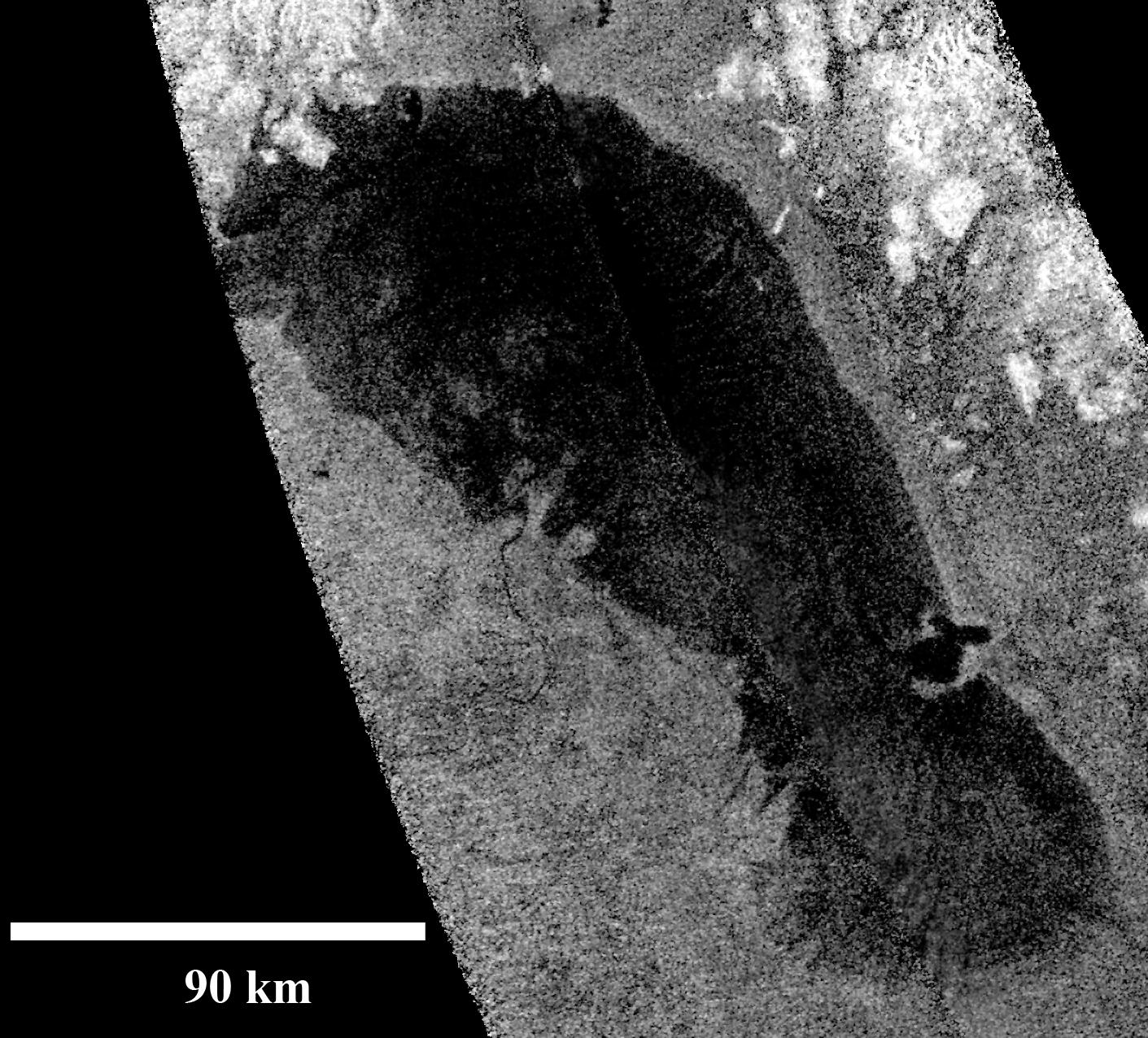
| DescrizioneCassini-OntarioLacus-RADAR.jpg |
English: This RADAR-image of Ontario Lacus, the largest lake on the southern hemisphere of Saturn's moon Titan, was obtained by NASA's Cassini spacecraft on Jan. 12, 2010. North is up in this image.
Objects appear bright in this radar image when they are tilted toward the spacecraft or have rough surfaces. The lake surface appears dark because it is smooth. The northern shoreline features flooded river valleys and hills as high as 1 kilometer (3,000 feet) in altitude. A smooth, wave-sculpted shoreline, like that seen on the southeastern side of Lake Michigan, can be seen at the northeastern part of the lake. Smooth lines parallel to the current shoreline could be formed by low waves over time, which were likely driven by winds sweeping in from the west or southwest. The southeast shore features a round-headed bay intruding into the shore. The liquid-filled depressions appear to be relatively recent. The middle part of the western shoreline shows the first well-developed delta observed on Titan. The shape of the delta shows that liquid flowing down from a higher plain has switched channels on its way into the lake, forming at least two lobes. Examples of this kind of channel switching and wave-modified deltas can be found on Earth at the southern end of Lake Albert between Uganda and the Democratic Republic of Congo in Africa and the remains of an ancient lake known as Megachad in the African country Chad.Deutsch: Radarabtastung des Ontario Lacus, des größten Ethan-Methan-Sees auf der Südhalbkugel des größten Saturnmondes Titan aufgenommen durch die Raumsonde Cassini am 12. Januar, 2010.
Das nördliche Ufer ist geprägt durch ca. 1 km hohe Hügel sowie überflutete Flusstäler. Eine gerade verlaufende, wellengeformte Küstenlinie, ähnlich der des südwestlichen Michigansees, kann im nordöstlichen Bereich beobachtet werden. Parallel zum gegenwärtigen Ufer verlaufende Linien könnten über längere Zeiträume durch niedrige Wellen geformt worden sein, welche wiederum vermutlich aufgrund von West- oder Südwestwinden entstehen. Die südöstliche Küste zeigt eine rundliche, weit in den See ragende Bucht. Der mittlere Teil der westlichen Küste weist das erste beobachtete und gut ausgeprägte Flussdelta auf Titan auf. Ähnlich dem Rhône-Delta in der französischen Camargue, handelt es sich seiner Morphologie nach zu urteilen um ein wellendominiertes Delta, bei dem von höherliegenden Gebieten kommende flüssige Kohlenwasserstoffe auf ihrem Weg zum See ihre Flussrinne wechseln und so mindestens zwei Halbinseln geschaffen haben. Weitere Beispiele solcher Rinnenwechsel bzw. wellendominierter Deltas können auf der Erde am südlichen Ende des Albertsees in Afrika zwischen Uganda und der Demokratischen Republik Kongo sowie als Überreste des einstigen Binnenmeeres Mega-Tschad im Tschad gefunden werden. |
| Data | |
| Fonte | http://photojournal.jpl.nasa.gov/catalog/PIA13172 |
| Autore | NASA/JPL-Caltech |
Licenza
| Public domainPublic domainfalsefalse |
| Questo file è nel pubblico dominio perché creato dalla NASA. La politica sul copyright della NASA afferma che «il materiale della NASA non è protetto da copyright a meno che non sia specificato altrimenti». (NASA copyright policy e JPL Image Use Policy). | ||
 |
Attenzione:
|
Didascalie
Elementi ritratti in questo file
raffigura
12 gen 2010
image/jpeg
ab84c2bf3d816b035609a2436759293399f9652a
337 070 byte
1 276 pixel
1 411 pixel
Cronologia del file
Fare clic su un gruppo data/ora per vedere il file come si presentava nel momento indicato.
| Data/Ora | Miniatura | Dimensioni | Utente | Commento | |
|---|---|---|---|---|---|
| attuale | 20:08, 22 lug 2010 | | 1 411 × 1 276 (329 KB) | 36ophiuchi~commonswiki | {{Information |Description={{en|1= This RADAR-image of Ontario Lacus, the largest lake on the southern hemisphere of Saturn's moon Titan, was obtained by NASA's Cassini spacecraft on Jan. 12, 2010. North is up in this image. Objects appear bright |
Pagine che usano questo file
Le seguenti 2 pagine usano questo file:
Utilizzo globale del file
Anche i seguenti wiki usano questo file:
- Usato nelle seguenti pagine di ar.wikipedia.org:
- Usato nelle seguenti pagine di ca.wikipedia.org:
- Usato nelle seguenti pagine di cs.wikipedia.org:
- Usato nelle seguenti pagine di de.wikipedia.org:
- Usato nelle seguenti pagine di en.wikipedia.org:
- Usato nelle seguenti pagine di en.wiktionary.org:
- Usato nelle seguenti pagine di fr.wikipedia.org:
- Usato nelle seguenti pagine di hr.wikipedia.org:
- Usato nelle seguenti pagine di id.wikipedia.org:
- Usato nelle seguenti pagine di it.wikibooks.org:
- Usato nelle seguenti pagine di it.wikiversity.org:
- Usato nelle seguenti pagine di ja.wikipedia.org:
- Usato nelle seguenti pagine di ko.wikipedia.org:
- Usato nelle seguenti pagine di lb.wikipedia.org:
- Usato nelle seguenti pagine di nn.wikipedia.org:
- Usato nelle seguenti pagine di no.wikipedia.org:
- Usato nelle seguenti pagine di pl.wikipedia.org:
- Usato nelle seguenti pagine di pt.wikipedia.org:
- Usato nelle seguenti pagine di ru.wikipedia.org:
- Usato nelle seguenti pagine di www.wikidata.org:
Metadati
Questo file contiene informazioni aggiuntive, probabilmente aggiunte dalla fotocamera o dallo scanner usati per crearlo o digitalizzarlo. Se il file è stato modificato, alcuni dettagli potrebbero non corrispondere alla realtà.
| _error | 0 |
|---|