파일:China-Inner-Mongolia.png
From Wikipedia, the free encyclopedia
최대 해상도입니다.
China-Inner-Mongolia.png (268 × 218 픽셀, 파일 크기: 15 KB, MIME 종류: image/png)
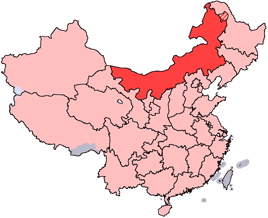
en: Location of Inner Mongolia Autonomous Region in the People's Republic of China. See Locator maps of province-level divisions of the People's Republic of China for more information. The striped area is nominally part of Inner Mongolia, but it is administered by Daxing'anling Prefecture of Heilongjiang Province.
zh: 内蒙古自治區在中華人民共和國的位置。另見Locator maps of province-level divisions of the People's Republic of China。加斜杠的地區由黑龍江省大興安嶺地區所管轄,僅在名義上為内蒙古的一部分。

|
GNU 자유 문서 사용 허가서 1.2판 또는 자유 소프트웨어 재단에서 발행한 이후 판의 규정에 따라 본 문서를 복제하거나 개작 및 배포할 수 있습니다. 본 문서에는 변경 불가 부분이 없으며, 앞 표지 구절과 뒷 표지 구절도 없습니다. 본 사용 허가서의 전체 내용은 GNU 자유 문서 사용 허가서 부분에 포함되어 있습니다.http://www.gnu.org/copyleft/fdl.htmlGFDLGNU Free Documentation Licensetruetrue |
| 이 파일은 크리에이티브 커먼즈 저작자표시-동일조건변경허락 3.0 Unported 라이선스로 배포됩니다. | ||
| ||
| 이 라이선스 틀은 GFDL 라이선스 변경의 일부로 이 파일에 추가되었습니다.http://creativecommons.org/licenses/by-sa/3.0/CC BY-SA 3.0Creative Commons Attribution-Share Alike 3.0truetrue |
설명
이 파일이 나타내는 바에 대한 한 줄 설명을 추가합니다
이 파일에 묘사된 항목
다음을 묘사함
image/png
15,782 바이트
218 화소
268 화소
파일 역사
날짜/시간 링크를 클릭하면 해당 시간의 파일을 볼 수 있습니다.
| 날짜/시간 | 섬네일 | 크기 | 사용자 | 설명 | |
|---|---|---|---|---|---|
| 현재 | 2005년 7월 15일 (금) 23:44 | | 268 × 218 (15 KB) | Schaengel89~commonswiki | transparent background |
| 2005년 6월 5일 (일) 06:42 |  | 268 × 218 (9 KB) | Ran | '''en''': Location of Inner Mongolia in the People's Republic of China. See Category:Locator maps of province-level divisions of the People's Republic of China for more information. '''zh''': 内蒙古自治區在中華人民共和國的位置。另 |
이 파일을 사용하는 문서
다음 문서 6개가 이 파일을 사용하고 있습니다:
이 파일을 사용하고 있는 모든 위키의 문서 목록
다음 위키에서 이 파일을 사용하고 있습니다:
- da.wikipedia.org에서 이 파일을 사용하고 있는 문서 목록
- de.wikipedia.org에서 이 파일을 사용하고 있는 문서 목록
- en.wikipedia.org에서 이 파일을 사용하고 있는 문서 목록
- Wikipedia:WikiProject Chinese provinces/Locator maps
- Fengzhen
- Yin Mountains
- Hanggai (village)
- Tengger Desert
- Liaobei
- Dolon Nor
- Oroqen Autonomous Banner
- Solun, Horqin Right Front Banner
- Khalkhin Gol
- Bailingmiao
- Dongsheng District
- Chifeng Yulong Airport
- Hulunbuir Hailar Airport
- Tongliao Airport
- Xilinhot Airport
- Template:InnerMongolia-geo-stub
- Lang Mountains
- Tsondol
- Xar Moron River
- Honggor Sum, Siziwang Banner
- Baochang, Taibus Banner
- Hobor
- Honggor Sum, Sonid Left Banner
- Hongort
- Shangdu County
- Xuejiawan, Jungar Banner
- Dashuigou Formation
- Bayin-Gobi Formation
- Jalaid Banner
- Hexigten Banner
- Horinger County
- Xincheng, Hohhot
- Wuyuan County, Inner Mongolia
이 파일의 더 많은 사용 내역을 봅니다.